
Ross Island is an island in Antarctica lying on the east side of McMurdo Sound and extending 43 nautical miles from Cape Bird on the north to Cape Armitage on the south, and a like distance from Cape Royds on the west to Cape Crozier on the east. The island is entirely volcanic. Mount Erebus, 3,795 metres (12,451 ft), near the center, is an active volcano. Mount Terror, 3,230 metres (10,600 ft), about 20 nautical miles eastward, is an extinct volcano. Mount Bird rises to 1,765 metres (5,791 ft) just south of Cape Bird. Ross Island lies within the boundary of Ross Dependency, an area of Antarctica claimed by New Zealand.
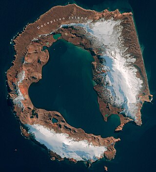
Deception Island is in the South Shetland Islands close to the Antarctic Peninsula with a large and usually "safe" natural harbor, which is occasionally affected by the underlying active volcano. This island is the caldera of an active volcano, which seriously damaged local scientific stations in 1967 and 1969. The island previously held a whaling station. It is now a tourist destination with over 15,000 visitors per year. Two research stations are operated by Argentina and Spain during the summer season. While various countries have asserted sovereignty, it is still administered under the Antarctic Treaty System.

Operation Tabarin was the code name for a secret British expedition to the Antarctic during World War Two, operational 1943–46. Conducted by the Admiralty on behalf of the Colonial Office, its primary objective was to strengthen British claims to sovereignty of the British territory of the Falkland Islands Dependencies (FID), to which Argentina and Chile had made counter claims since the outbreak of war. This was done by establishing permanently occupied bases, carrying out administrative activities such as postal services and undertaking scientific research. The meteorological observations made aided Allied shipping in the South Atlantic Ocean.
Hope Bay is a bay 3 nautical miles long and 2 nautical miles wide, indenting the tip of the Antarctic Peninsula and opening on Antarctic Sound.

The Fildes Peninsula is a 7 km (4.3 mi) long peninsula that forms the south-western end of King George Island in the South Shetland Islands of Antarctica. It was named from association with nearby Fildes Strait by the UK Antarctic Place-Names Committee in 1960; the strait was likely named for Robert Fildes, a British sealer of the 1800s.

Argentine Antarctica is an area on Antarctica claimed by Argentina as part of its national territory. It consists of the Antarctic Peninsula and a triangular section extending to the South Pole, delimited by the 25° West and 74° West meridians and the 60° South parallel. This region overlaps with British and Chilean claims in Antarctica. None of these claims have widespread international recognition.

Multiple governments have set up permanent research stations in Antarctica and these bases are widely distributed. Unlike the drifting ice stations set up in the Arctic, the current research stations of the Antarctic are constructed either on rocks or on ice that are fixed in place.

Bellingshausen Station is a Russian Antarctic station at Collins Harbour, on King George Island of the South Shetland Islands. It was one of the first research stations founded by the Soviet Antarctic Expedition in 1968. It is also the location of Trinity Church, the only permanently staffed Eastern Orthodox church in Antarctica.
Base Presidente Eduardo Frei Montalva is the most important Antarctic base of Chile. It is located at Fildes Peninsula, an ice-free area, in front of Fildes Bay, at the west end of King George Island, South Shetland Islands. Situated alongside the Escudero Station and only 200 metres (660 ft) from the Russian Bellingshausen Station, it is at an altitude of 10 metres (33 ft) above sea-level. The base is located in the Chilean commune of Antártica, which is the Antarctic territory claimed by Chile.
Profound Lake or Lake Profound is a lake 400 metres northwest of Jasper Point in northeast Fildes Peninsula, King George Island. The feature was named "Ozero Glubokoye" by the Soviet Antarctic Expedition working from Bellingshausen Station from 1968, but both forms of the name are already in use in the Antarctic. The United Kingdom Antarctic Place-Names Committee (UK-APC) amended the name in 1979 to avoid duplication.

The General Artigas Station, also referred to as the Artigas Base is the larger of the two Uruguayan scientific research stations in Antarctica, the other one being Elichiribehety Base. It is one of the 68 bases in Antarctica.

The Uruguayan Antarctic Institute is Uruguay's governmental agency to fund, organize, control and promote research on Antarctica according with the Antarctic Treaty System. It was founded by scientists, and is now managed by Uruguay's Ministries of Defense, Foreign Affairs and Education.

The Great Wall Station is the first Chinese research station in Antarctica and opened on 20 February 1985. It lies on the Fildes Peninsula on King George Island, 960 kilometres (600 mi) from Cape Horn. It is sited on ice-free rock, about 10 metres (33 ft) above sea level.

The Vernadsky Research Base is a Ukrainian Antarctic research station at Marina Point on Galindez Island in the Argentine Islands, not far from Kyiv Peninsula. The region is under territorial claims between three countries. The single Ukrainian Antarctic station is named after the mineralogist Vladimir Vernadsky (1863–1945) who was the first president of the National Academy of Sciences of Ukraine.

Neko Harbour is an inlet of the Antarctic Peninsula on Andvord Bay, situated on the west coast of Graham Land.

View Point is 150m long eastern tip of a promontory, on Antarctica, forming the west side of the entrance to Duse Bay on the south coast of Trinity Peninsula, on the northern portion of the Antarctic Peninsula. Situated 6.79 km east of Skomlya Hill and 6.45 km southeast of Boil Point. Discovered by a party under J. Gunnar Andersson of the Swedish Antarctic Expedition, 1901-04. So named by the Falkland Islands Dependencies Survey (FIDS) following their survey of the area in 1945 because from this promontory, good panoramic photographs were obtained.

Primavera Base is an Argentine Antarctic base and scientific research station. It is located on Primavera Cape, Cierva Cove, on San Martín Land, Antarctic Peninsula.
The Collins base is an Antarctic shelter located in the Collins Glacier that is in the Collins Bay in the Fildes Peninsula, King George Island. It was inaugurated at the 2006-2007 season and is administrated by the Instituto Antártico Chileno (INACH).

Doctor Guillermo Mann Base is a Chilean Antarctic research base. It is located on the east side of Cape Shirreff on Ioannes Paulus II Peninsula on Livingston Island in the South Shetland Islands off the Antarctic peninsula.

International competition extended to the continent of Antarctica during the World War II era, though the region saw no combat. During the prelude to war, Nazi Germany organised the 1938 Third German Antarctic Expedition to preempt Norway's claim to Queen Maud Land. The expedition served as the basis for a new German claim, called New Swabia. A year later, the United States Antarctic Service Expedition established two bases, which operated for two years before being abandoned. Responding to these encroachments, and taking advantage of Europe's wartime turmoil, the nearby nations of Chile and Argentina made their own claims. In 1940 Chile proclaimed the Chilean Antarctic Territory in areas already claimed by Britain, while Argentina proclaimed Argentine Antarctica in 1943 in an overlapping area.


