| |
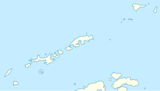 Elephant Location in the South Shetland Islands  Elephant Location in Antarctica | |
| Geography | |
|---|---|
| Location | Antarctica |
| Coordinates | 61°08′S55°07′W / 61.14°S 55.12°W |
| Archipelago | South Shetland Islands |
| Area | 558 km2 (215 sq mi) |
| Length | 47 km (29.2 mi) |
| Width | 27 km (16.8 mi) |
| Highest elevation | 973 m (3192 ft) |
| Highest point | Mount Pendragon |
| Administration | |
| Administered under the Antarctic Treaty | |
| Demographics | |
| Population | Uninhabited |
Elephant Island is an ice-covered, mountainous island off the coast of Antarctica in the outer reaches of the South Shetland Islands, in the Southern Ocean. The island is situated 245 kilometres (152 miles) north-northeast of the tip of the Antarctic Peninsula, 1,253 kilometres (779 miles) west-southwest of South Georgia, 935 kilometres (581 miles) south of the Falkland Islands, and 885 kilometres (550 miles) southeast of Cape Horn. It is within the Antarctic claims of Argentina, Chile and the United Kingdom.
Contents
- Toponym
- Geography
- Geology
- Flora and fauna
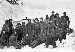
- History
- First Russian Antarctic expedition
- Endurance expedition
- Joint Services Expeditions 1970–71
- Historic sites
- Maps
- See also
- References
- Bibliography
- External links
The Brazilian Antarctic Program maintains a shelter on the island, Goeldi, [1] and formerly had another (Wiltgen) supporting the work of up to six researchers each during the summer. Wiltgen was dismantled in the summers of 1997 and 1998.