
Sea Lion Glacier is the site of an isolated 350 metres (1,150 ft) long glacier on Hurd Peninsula, eastern Livingston Island in the South Shetland Islands, Antarctica. It is located southwest of Hesperides Hill and northwest of Atlantic Club Ridge, separated from the latter by Sea Lion Tarn, and terminating on the South Bay coast.
Varna Peninsula is a roughly rectangular predominantly ice-covered peninsula forming the northeast extremity of Livingston Island in the South Shetland Islands, Antarctica. It is bounded by Hero Bay to the northwest, by Moon Bay to the southeast, and by McFarlane Strait to the northeast.

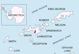
Vergilov Rocks are a group of rocks off Bulgarian Beach on Hurd Peninsula in eastern Livingston Island in the South Shetland Islands, Antarctica, consisting of one main rock and two adjacent smaller ones submerging at high water.

Ballester Point is a point forming the south side of the entrance to Johnsons Dock and the northeast side of the entrance to Española Cove in Hurd Peninsula, Livingston Island in the South Shetland Islands, Antarctica. The area was visited by early 19th century sealers operating from Johnsons Dock.

Johnsons Glacier is the 1.8 km long and 2.3 km wide glacier on Hurd Peninsula, Livingston Island in the South Shetland Islands, Antarctica bounded by Charrúa Ridge and Charrúa Gap to the north, Napier Peak to the east, Mirador Hill to the southeast, Hurd Ice Cap to the southwest and Mount Reina Sofía to the west. It is draining northwestwards into Johnsons Dock. The glacier provides overland access from the Spanish base Juan Carlos Primero to the interior of the eastern Livingston Island.
Contell Glacier is 1.2 nmi long and 0.4 nautical miles wide glacier on Hurd Peninsula, Livingston Island in the South Shetland Islands, Antarctica bounded by Atlantic Club Ridge to the northwest, Krum Rock to the north, Balkan Snowfield to the northeast, and Charrúa Ridge and Charrúa Gap to the south. It is crescent-shaped, running northwestwards in its upper course, then between Charrúa Ridge and Krum Rock turning west-southwestwards to flow into South Bay north of Johnsons Dock.
Binn Peak is the conspicuous rocky peak rising to 400 m above Miers Bluff at the southwest extremity of Hurd Peninsula, Livingston Island in the South Shetland Islands, Antarctica.
Polish Bluff is a point forming the southwest side of the entrance to Española Cove and the northeast side of the entrance to Argentina Cove in Hurd Peninsula, Livingston Island in the South Shetland Islands, Antarctica. The area was visited by early 19th century sealers operating from nearby Johnsons Dock.
Henry Bluff is a point forming the southwest side of the entrance to Argentina Cove and the north side of the entrance to Las Palmas Cove in Hurd Peninsula, Livingston Island in the South Shetland Islands, Antarctica. The point is dominated by a prominent monolithic formation rising to 163 m and named El Peñón by personnel of the nearby Spanish Antarctic Base. The area was visited by early 19th century sealers operating from nearby Johnsons Dock.
Española Cove is a 1.2 km wide embayment indenting for 250 m the northwest coast of Hurd Peninsula, Livingston Island in the South Shetland Islands, Antarctica. It is part of South Bay entered between Ballester Point and Polish Bluff. The cove is used for the transfer of people and cargo to the Spanish base Juan Carlos I situated at its head. The area was frequented by early 19th century sealers operating from nearby Johnsons Dock.
Argentina Cove is a 1.28 km wide embayment indenting for 330 m the southeast coast of Hurd Peninsula, Livingston Island in the South Shetland Islands, Antarctica. It is part of South Bay, entered between Polish Bluff and Henry Bluff. The area was frequented by early 19th century sealers operating from nearby Johnsons Dock.
Las Palmas Cove is a 1.97 km wide embayment indenting for 500 m the northwest coast of Hurd Peninsula on Livingston Island in the South Shetland Islands, Antarctica. It is part of South Bay, Livingston Island entered between Henry Bluff and Salisbury Bluff. The area was visited by early 19th century sealers operating from nearby Johnsons Dock. It also where the Las Palmas Glacier terminates.

Raquelia Rocks is a group of three adjacent rocks in eastern South Bay, Livingston Island in the South Shetland Islands, Antarctica formed by an offshoot of Atlantic Club Ridge halfway along the Zodiac boat route linking the Spanish Antarctic Base and the Bulgarian Antarctic Base on the island. The area was visited by early 19th century sealers operating from nearby Johnsons Dock.
Mount Reina Sofía is the mostly ice-free peak rising to 275 m on Hurd Peninsula, Livingston Island in the South Shetland Islands, Antarctica and surmounting Johnsons Glacier to the east and northeast, and the Spanish Antarctic base Juan Carlos Primero to the north-northwest.
Hurd Ice Cap is the ice cap covering the central area of southern Hurd Peninsula, Livingston Island in the South Shetland Islands, Antarctica. It extends 4.5 km in northeast-southwest direction and 3.7 km in northwest-southeast direction, and drains both into South Bay to the northwest and into False Bay to the southeast. Its summit point has been nicknamed named Dorotea by personnel of the nearby Spanish base Juan Carlos Primero and rises to 332 m.
Buena Nueva Cove is a small open cove, 900 m wide and indenting for 200 m the northwest coast of False Bay, Livingston Island in the South Shetland Islands, Antarctica southeast of MacGregor Peaks and east of Castro Peak on Hurd Peninsula. The area was visited by early 19th century sealers.
Glaciar Rocoso Cove is a small open cove, part of False Bay, Livingston Island in the South Shetland Islands, Antarctica. It is 920 m wide and indenting for 180 m the southeast coast of Hurd Peninsula east-northeast of Binn Peak and south-southwest of Nusha Hill. The area was visited by early 19th century sealers.
Nusha Hill is the rocky hill rising to 251 m in southern Hurd Peninsula on Livingston Island in the South Shetland Islands, Antarctica. It has precipitous east, south and west slopes, and is linked to Doc Peak to the north by a col of elevation 220 m. Nusha Hill surmounts a rock glacier to the west and southwest, False Bay to the east and its sub-embayment Glaciar Rocoso Cove to the south-southwest. The adjacent area, subject to geological and glaciological field work, is accessible by sea or by an overland route running from Hurd Ice Cap along the South Bay coast facing Sally Rocks and via a saddle of elevation 122 m situated 800 m west by south of the hill.
Vergilov Ridge is a submarine ridge in South Bay, Livingston Island in the South Shetland Islands, Antarctica. It extends 3.5 km in a southeast-northwest direction between the Vergilov Rocks and the opposite Pimpirev Beach at a depth of over 50 m, with depths exceeding 100 m on both sides of the ridge. It was formed as a frontal moraine of Perunika Glacier between the 13th and 17th centuries.


