Dunbar Islands

Last updated
Dunbar Islands
Livingston-Island-location-map.png
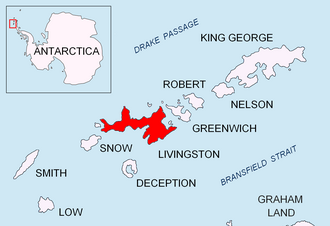
Location of Livingstone Island in the South Shetland Islands
Antarctic Peninsula location map.svg
Red pog.svg
Dunbar Islands
Location of Dunbar Islands
Antarctica relief location map.jpg
Red pog.svg
Dunbar Islands
Dunbar Islands (Antarctica)
Geography
Location Antarctica
Coordinates 62°28′10″S60°10′40″W / 62.46944°S 60.17778°W / -62.46944; -60.17778 Coordinates: 62°28′10″S60°10′40″W / 62.46944°S 60.17778°W / -62.46944; -60.17778
Archipelago South Shetland Islands
Administration
Administered under the Antarctic Treaty System
Demographics
PopulationUninhabited
Topographic map of Livingston Island, Greenwich, Robert, Snow and Smith Islands. Livingston-Island-Map-2010.jpg
Topographic map of Livingston Island, Greenwich, Robert, Snow and Smith Islands.

The Dunbar Islands are a small group of islands lying off Varna Peninsula southwest of Williams Point, the northeast extremity of Livingston Island in the South Shetland Islands, Antarctica comprising the islands of Aspis, Balsha, Melyane, Pogledets and Zavala, and several minor islets and rocks. The area was visited by early 19th century sealers.

Contents

The islands are named after Captain Thomas Dunbar, Master of the American sealing schooner Free Gift which visited the South Shetland Islands in 1820–21.

Location

The midpoint of the group is located at 62°28′10″S60°10′40″W / 62.46944°S 60.17778°W / -62.46944; -60.17778 (British mapping in 1968, Spanish in 1991, and Bulgarian in 2005 and 2009).

Maps

See also

Dunbar Islands (in the foreground) from Miziya Peak, Livingston Island, with Williams Point on the right and Zed Islands in the background Dunbar.jpg
Dunbar Islands (in the foreground) from Miziya Peak, Livingston Island, with Williams Point on the right and Zed Islands in the background


Related Research Articles

Debelt Glacier glacier in Antarctica

The Debelt Glacier on Varna Peninsula, Livingston Island in the South Shetland Islands, Antarctica is situated southeast of Rose Valley Glacier and northeast of Panega Glacier. It drains the southeastern slopes of Vidin Heights and flows into Moon Bay between Edinburgh Hill and Helis Nunatak. The glacier extends three km in an east-west direction, and 1.5 km in north-south direction.

Kabile Island

Kabile Island is an Antarctic island extending 700 m (770 yd) in south-north direction and 450 m (490 yd) wide, situated off the north coast of Greenwich Island in the South Shetland Islands, Antarctica. It has a surface area of 19 hectares.

Vergilov Rocks

Vergilov Rocks are a group of rocks off Bulgarian Beach on Hurd Peninsula in eastern Livingston Island in the South Shetland Islands, Antarctica, consisting of one main rock and two adjacent smaller ones submerging at high water.

Desolation Island (South Shetland Islands)

Desolation Island is one of the minor islands in the South Shetlands archipelago, Antarctica situated at the entrance to Hero Bay, Livingston Island. The island is V-shaped with its northern coast indented by Kozma Cove. Surface area 3.12 square kilometres (1.20 sq mi).

Iratais Point

Iratais Point is a point forming both the south extremity and the vertex of the V-shaped Desolation Island situated in the entrance to Hero Bay, Livingston Island, Antarctica. Separated from Miladinovi Islets to the south by Neck or Nothing Passage.

Vardim Rocks

Vardim Rocks are a group of rocks situated on the south side of Hell Gates, facing Devils Point in the southwest extremity of Byers Peninsula on Livingston Island in the South Shetland Islands, Antarctica. Extending 1.3 km (0.81 mi) in east-west direction. The two principal islets in the group, Demon and Sprite, are extending 420 by 400 m and 270 by 150 m respectively, with surface area of the former 9 hectares. The area was visited by early 19th century sealers.

Telish Rock

Telish Rock is the islet off the south coast of Livingston Island in the South Shetland Islands, Antarctica situated 400 m (437 yd) south of Elephant Point and 3 km (1.86 mi) northwest by west of Enchantress Rocks. Extending 300 by 180 m. The area was visited by early 19th century sealers.

Balsha Island

Balsha Island is an ice-free island in the Dunbar group off the northwest coast of Varna Peninsula, Livingston Island in the South Shetland Islands, Antarctica. It is situated 1.5 km (0.93 mi) northwest of Slab Point and 2.8 km (1.7 mi) north of Kotis Point. Extending 600 by 300 m, surface area 17 hectares. The area was visited by early 19th century sealers.

Zavala Island

Zavala Island is an ice-free island in the Dunbar group off the northwest coast of Varna Peninsula on Livingston Island in the South Shetland Islands, Antarctica. It is extending 700 by 250 m, with surface area 14 hectares. The area was visited by early 19th century sealers.

Window Island

Window Island is a small ice-free island off the north coast of Ray Promontory in the northwest of Byers Peninsula, Livingston Island in the South Shetland Islands, Antarctica. The island has a surface area of 23 hectares and rises to 72 m (236 ft). It was known to the early 19th century sealers operating on Byers Peninsula.

Meade Islands

The Meade Islands are a group of two large islands, Zverino Island and Cave Island, the minor Pisanitsa Island, and several rocks lying in the north entrance to McFarlane Strait, off Archar Peninsula, Greenwich Island in the South Shetland Islands, Antarctica. The surface areas of the first two islands are 48 hectares and 18 hectares. respectively. The area was visited by early 19th century sealers.

Morris Rock

Morris Rock is rising to 55 m (180 ft) in the northwest extremity of Aitcho group, English Strait in the South Shetland Islands, Antarctica. The area was visited by early 19th century sealers.

Stoker Island

Stoker Island is a rocky island lying off the north coast of Greenwich Island in the South Shetland Islands, Antarctica. Extending 550 by 400 m, surface area 20 hectares. The area was visited by early 19th century sealers.

Ongley Island

Ongley Island is a rugged rocky island lying off the north coast of Greenwich Island in the South Shetland Islands, Antarctica. Extending 1.35 km (0.84 mi) in west-northwest direction and 470 m (510 yd) wide, with a surface area of 44 hectares. The area was visited by early 19th century sealers.

Romeo Island

Romeo Island is a rocky island lying off the north coast of Greenwich Island and west of Aitcho Islands in the South Shetland Islands, Antarctica. Extending 1.35 km (0.84 mi) in west-northwest direction and 470 m (510 yd) wide, with a surface area of 44 hectares. The area was visited by early 19th century sealers.

Aspis Island

Aspis Island is a small, low-lying, ice-free island rising to 15 metres (49 ft), easternmost in the Dunbar group off the northwest coast of Varna Peninsula, Livingston Island in the South Shetland Islands, Antarctica.

Raquelia Rocks Group of three rocks on Livingston Island, South Shetland Islands, Antarctica

Raquelia Rocks is a group of three adjacent rocks in eastern South Bay, Livingston Island in the South Shetland Islands, Antarctica formed by an offshoot of Atlantic Club Ridge halfway along the Zodiac boat route linking the Spanish Antarctic Base and the Bulgarian Antarctic Base on the island. The area was visited by early 19th century sealers operating from nearby Johnsons Dock.

Hetty Rock

Hetty Rock is the largest of several rocks in Walker Bay off John Beach in western Livingston Island in the South Shetland Islands, Antarctica. The area was visited by early 19th century sealers.

Eddystone Rocks (South Shetland Islands) Group of two rocks in the South Shetland Islands, Antarctica.

Eddystone Rocks is a group of two rocks lying to the northwest of Rugged Island off western Livingston Island in the South Shetland Islands, Antarctica.

Vodoley Rock

Vodoley Rock is the rock extending 220 m in northwest-southeast direction and 110 m wide in Barclay Bay on the west side of Ioannes Paulus II Peninsula on Livingston Island in the South Shetland Islands, Antarctica. The area was visited by early 19th century sealers operating on nearby Byers Peninsula and Cape Shirreff.