Thurston Island is an ice-covered, glacially dissected island, 215 km (134 mi) long, 90 km (56 mi) wide and 15,700 km2 (6,062 sq mi) in area, lying a short way off the northwest end of Ellsworth Land, Antarctica. It is the third largest island of Antarctica, after Alexander Island and Berkner Island.

Dundee Island is an ice-covered island lying east of the northeastern tip of Antarctic Peninsula and south of Joinville Island.

Coronation Island is the largest of the South Orkney Islands, 25 nautical miles (46 km) long and from 3 to 8 nautical miles wide. The island extends in a general east-west direction, is mainly ice-covered and comprises numerous bays, glaciers and peaks, the highest rising to 1,265 metres (4,150 ft).

The Windmill Islands are an Antarctic group of rocky islands and rocks about 11.1 kilometres (6 nmi) wide, paralleling the coast of Wilkes Land for 31.5 kilometres (17 nmi) immediately north of Vanderford Glacier along the east side of Vincennes Bay. Kirkby Shoal is a small shoal area with depths of less than 18 metres (59 ft) extending about 140 metres (459 ft) westwards and SSW, about 3.4 kilometres (2.1 mi) from the summit of Shirley Island, Windmill Islands, and 0.24 kilometres (0.15 mi) NW of Stonehocker Point, Clark Peninsula.

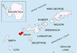
Snow Hill Island is an almost completely snowcapped island, 33 km (21 mi) long and 12 km (7.5 mi) wide, lying off the east coast of the Antarctic Peninsula. It is separated from James Ross Island to the north-east by Admiralty Sound and from Seymour Island to the north by Picnic Passage. It is one of several islands around the peninsula known as Graham Land, which is closer to South America than any other part of the Antarctic continent.

The Ibar Rocks are two rocks located 0.4 kilometres (0.2 nmi) east of Bonert Rock and 1 kilometre (0.6 nmi) southeast of Canto Point, Greenwich Island, in the South Shetland Islands. The names "Islote Ibar" and "Islote Teniente Ibar" appearing on Chilean hydrographic charts in the 1950s refer to the larger and western rock. The recommended name "Ibar Rocks" includes a submerged outlier to the northeast of the larger rock. Teniente (lieutenant) Mario Ibar P. signed the official act of inauguration of the Chilean Captain Arturo Prat Base on Greenwich Island in 1947.

Endurance Glacier is a broad glacier north of Mount Elder, draining south-east to the south coast of Elephant Island in the South Shetland Islands of Antarctica, and is the main discharge glacier on the island. It was named by the UK Antarctic Place-Names Committee after HMS Endurance, which anchored off the glacier on several occasions in support of the Joint Services Expedition to Elephant Island, 1970–71.

The Asses Ears are a set of three small islands off northwest Robert Island, forming the north part of Potmess Rocks in English Strait, South Shetland Islands. Presumably known to early sealers, the feature was charted and named descriptively by personnel on Discovery II in 1934–35.

Aim Rocks is a group of rocks lying east of Cape Timblón in the middle of Morton Strait in the South Shetland Islands, Antarctica. The name, given by the United Kingdom Antarctic Place-Names Committee in 1961, is descriptive; these rocks in line are a guide for safe passage through the southern entrance of Morton Strait.
Morton Strait is the 9 km (4.9 nmi)-long and 6.2 km (3.3 nmi)-wide strait between Snow Island on the southwest and Rugged Island and Livingston Island on the northeast, in the South Shetland Islands, Antarctica. The Aim Rocks and Long Rock lie in the strait.

Arthur Glacier is a valley glacier in Antarctica. It is about 25 nautical miles (50 km) long, and flows west to Sulzberger Ice Shelf between the Swanson Mountains on the north and Mount Rea and Mount Cooper on the south, in the Ford Ranges of Marie Byrd Land. It was discovered by members of West Base of the United States Antarctic Service, in aerial flights and from ground surveys in November–December 1940. It was named by the Advisory Committee on Antarctic Names for Rear Admiral Arthur C. Davis, a leader in aviation in the U.S. Navy.

Borceguí Island is an ice-free island in the South Shetland Islands, midway between Cape Yelcho and the Gibbous Rocks, 2 kilometres (1 nmi) off the north coast of Elephant Island. The name was applied by the command of the Argentine sea-going tug Chiriguano in the 1954–55 cruise; in Spanish "borceguí" means half-boot and describes the shape of the island.
Bulbur Glacier is a glacier in south-central Thurston Island; it flows south along the west side of Boker Rocks into O'Dowd Cove. It was named by the Advisory Committee on Antarctic Names after E.R. Bulbur, Photographer's Mate in the Eastern Group of U.S. Navy Operation Highjump, which obtained aerial photographs of Thurston Island and adjacent coastal areas, 1946–47.

Grace Rock is a rock in Bransfield Strait, Antarctica lying 1.72 kilometres (0.93 nmi) off the southeast coast of Nelson Island in the South Shetland Islands. It was named by the UK Antarctic Place-Names Committee in 1961 after the British sealing vessel Grace from Plymouth, which visited the South Shetland Islands in 1821–22.
Pig Rock is a rock, 65 m high, the largest of a group of rocks lying 1.9 kilometres (1 nmi) east of the east end of Nelson Island, in the South Shetland Islands. This rock, known to sealers in the area as early as 1821, was charted and named by DI personnel on the Discovery II in 1935.

Dufayel Island is an island lying near the center of Ezcurra Inlet, Admiralty Bay, in the South Shetland Islands. It was charted and named in December 1909 by the French Antarctic Expedition under Jean-Baptiste Charcot.
Gnomon Island is a small rocky island lying just north of Point Wild, on Elephant Island in the South Shetland Islands. It was charted by Ernest Shackleton's Endurance expedition, 1914–16, and so named by them because when viewed from Point Wild the shape of the feature is suggestive of a gnomon, the elevated arm of a sundial.
Long Glacier is a glacier about 8 nautical miles long in the southeastern part of Thurston Island, Antarctica. It flows south to the Abbot Ice Shelf, 14 nautical miles (26 km) west of Harrison Nunatak. The glacier was mapped by the United States Geological Survey from surveys and U.S. Navy air photos, 1960–66, and was named by the Advisory Committee on Antarctic Names (US-ACAN) for Fred A. Long, Jr., an aviation machinist of U.S. Navy Squadron VX-6, who wintered at Little America V in 1957 and was in Antarctica in the 1960–61 and 1962–63 seasons.
Hauken Rock is a rock lying nearly 1 nautical mile (2 km) east of the Ornen Rocks and 2 nautical miles (4 km) northeast of Cape Melville, the eastern extremity of King George Island, in the South Shetland Islands. It was named by the UK Antarctic Place-Names Committee in 1960 from association with Ornen Rocks. Hauken and Ørnen, the first two modern whale catchers, accompanied the floating factory ship Admiralen to the South Shetland Islands in January–February 1906.
Hole Rock is the largest of several rocks lying close north of North Foreland, the northeastly cape of King George Island, in the South Shetland Islands. It was charted in 1937 by Discovery Investigations personnel on the Discovery II and so named because a conspicuous hole extends through it.