Liberty Rocks

Last updated
Liberty Rocks
Nelson-Strait-location-map.png
Location of Liberty Rocks
Antarctic Peninsula location map.svg
Red pog.svg
Liberty Rocks
Location of Liberty Rocks
Antarctica relief location map.jpg
Red pog.svg
Liberty Rocks
Liberty Rocks (Antarctica)
Geography
Location Antarctica
Coordinates 62°18′50.6″S59°27′44.2″W / 62.314056°S 59.462278°W / -62.314056; -59.462278 Coordinates: 62°18′50.6″S59°27′44.2″W / 62.314056°S 59.462278°W / -62.314056; -59.462278
Archipelago South Shetland Islands
Administration
Administered under the Antarctic Treaty System
Demographics
PopulationUninhabited

Liberty Rocks is a group of four prominent adjacent rocks lying at the north entrance to Nelson Strait in the South Shetland Islands, Antarctica and extending 430 by 120 m (470 by 131 yd). The area was visited by early 19th-century sealers.

Nelson Strait (South Shetland Islands)

Nelson Strait is the 9 km long and 9.8 km wide strait lying between Robert Island and Nelson Island in the South Shetland Islands, Antarctica. The strait was explored by early 19th century sealers and first charted by Nathaniel Palmer in 1821. While it had a variety of different names in the past, the present name — probably taken from the adjacent Nelson Island — has become well established in international usage.

South Shetland Islands A group of islands north of the Antarctic Peninsula

The South Shetland Islands are a group of Antarctic islands with a total area of 3,687 square kilometres (1,424 sq mi). They lie about 120 kilometres (75 mi) north of the Antarctic Peninsula, and between 430 kilometres (270 mi) to 900 kilometres (560 mi) south-west from the nearest point of the South Orkney Islands. By the Antarctic Treaty of 1959, the islands' sovereignty is neither recognized nor disputed by the signatories and they are free for use by any signatory for non-military purposes.

Antarctica Polar continent in the Earths southern hemisphere

Antarctica is Earth's southernmost continent. It contains the geographic South Pole and is situated in the Antarctic region of the Southern Hemisphere, almost entirely south of the Antarctic Circle, and is surrounded by the Southern Ocean. At 14,200,000 square kilometres, it is the fifth-largest continent. For comparison, Antarctica is nearly twice the size of Australia. About 98% of Antarctica is covered by ice that averages 1.9 km in thickness, which extends to all but the northernmost reaches of the Antarctic Peninsula.

Contents

The feature is named after the British sealing vessel Liberty under Captain Peacock that visited the South Shetlands in 1821–22.

Location

The rocks are centred at 62°18′50.6″S59°27′44.2″W / 62.314056°S 59.462278°W / -62.314056; -59.462278 which is 3.95 km (2.45 mi) northeast of Newell Point, Robert Island, 1.65 km (1.03 mi) southeast of Mellona Rocks, 11.38 km (7.07 mi) west by south of Harmony Point, Nelson Island and 6 km (3.73 mi) northwest of Makresh Rocks (British mapping in 1822, 1962 and 1968, Chilean in 1971, Argentine in 1980, and Bulgarian in 2009).

Newell Point a peninsula on the Shetland Islands

Newell Point is the rocky point forming the northeast extremity of Robert Island in the South Shetland Islands, Antarctica and is a northwest entrance point of Nelson Strait.

Mellona Rocks

Mellona Rocks is a group of scattered rocks lying at the north entrance to Nelson Strait in the South Shetland Islands, Antarctica and extending 1.7 by 0.9 km. The area was known to the early 19th-century sealers and sometimes included under the names 'Heywood Islands' or 'Powels Islands'.

Harmony Point Antarctic Specially Protected Area

Harmony Point is a point which lies close west of Harmony Cove and forms the western extremity of Nelson Island, in the South Shetland Islands of Antarctica. It was charted in 1935 by Discovery Investigations personnel on the Discovery II, and named from association with Harmony Cove.

See also

Scientific Committee on Antarctic Research organization

The Scientific Committee on Antarctic Research (SCAR) is an interdisciplinary body of the International Council for Science (ICSU).

Territorial claims in Antarctica Wikimedia list article

There are seven sovereign states who currently maintain de jure, largely symbolic territorial claims in Antarctica: Argentina, Australia, Chile, France, New Zealand, Norway and the United Kingdom. These countries have tended to place their Antarctic scientific observation and study facilities within their respective claimed territories; however, a number of such facilities are located nowhere near the sectors claimed by their respective countries of operation, and there are multiple other countries such as Russia and the United States who, despite having no territorial claim of their own anywhere in Antarctica, have constructed large research facilities within the sectors claimed by other countries.

Maps

International Standard Book Number Unique numeric book identifier

The International Standard Book Number (ISBN) is a numeric commercial book identifier which is intended to be unique. Publishers purchase ISBNs from an affiliate of the International ISBN Agency.

Related Research Articles

Robert Island island of the South Shetland Islands in the Southern Ocean

Robert Island or Mitchells Island or Polotsk Island or Roberts Island is an island 11 miles (18 km) long and 8 miles (13 km) wide, situated between Nelson Island and Greenwich Island in the South Shetland Islands, Antarctica. Robert Island is located at 62°24′S59°30′W. Surface area 132 km2 (51 sq mi). The name "Robert Island" dates back to around 1821 and is now established in international usage.

Desolation Island (South Shetland Islands)

Desolation Island is one of the minor islands in the South Shetlands archipelago, Antarctica situated at the entrance to Hero Bay, Livingston Island. The island is V-shaped with its northern coast indented by Kozma Cove. Surface area 3.12 square kilometres (1.20 sq mi).

Voluyak Rocks

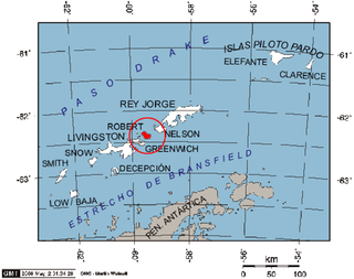
Voluyak Rocks is a chain of rocks off the north coast of Greenwich Island in the South Shetland Islands, Antarctica situated 400 m (440 yd) north of Pavlikeni Point. Extending 1.9 km (1.2 mi) in southeast-northwest direction.

Bistra Glacier glacier in Antarctica

Bistra Glacier is 1 nautical mile long and 0.4 nautical miles wide glacier on the northwest side of Imeon Range on Smith Island in the South Shetland Islands, Antarctica. It is situated southwest of Chuprene Glacier and northwest of Dragoman Glacier, drains the west slopes of Mount Foster and the north slopes of Slaveykov Peak, and flows northwestwards of Zavet Saddle to enter Drake Passage south of Garmen Point.

Barlow Island

Barlow Island is a small ice-free island off the north coast of Smith Island in the South Shetland Islands, Antarctica extending 380 by 160 m, surface area 5.28 hectares.

Window Island

Window Island is a small ice-free island off the north coast of Ray Promontory in the northwest of Byers Peninsula, Livingston Island in the South Shetland Islands, Antarctica. The island has a surface area of 23 hectares and rises to 72 m (236 ft). It was known to the early 19th century sealers operating on Byers Peninsula.

Cecilia Island

Cecilia Island is the ice-free southernmost island of the Aitcho group on the west side of English Strait in the South Shetland Islands, Antarctica. Extending 910 by 450 m, surface area 36 hectares. The area, visited by American and English sealers in the early 19th century, nowadays has become a popular tourist site frequented by Antarctic cruise ships.

Table Island (South Shetland Islands)

Table Island is a conspicuous flat-topped, rocky island lying north of Greenwich Island and north-northwest of the Aitcho group on the west side of English Strait in the South Shetland Islands, Antarctica. The island is rising to over 150 metres and extending 1.4 by 1 kilometre, with a surface area of 112 hectares. It is separated from Aitcho Islands to the south-southeast by the 1.9-kilometre (1.2-mile) wide Klimash Passage.

Romeo Island

Romeo Island is a rocky island lying off the north coast of Greenwich Island and west of Aitcho Islands in the South Shetland Islands, Antarctica. Extending 1.35 km (0.84 mi) in west-northwest direction and 470 m (510 yd) wide, with a surface area of 44 hectares. The area was visited by early 19th century sealers.

Cornwall Island (Antarctica)

Cornwall Island is a low ice-free island off the north coast of Robert Island in the South Shetland Islands, Antarctica. Surface area 15 hectares. Mónica Rock is lying 1.65 km (1.03 mi) west of the island and 3.4 km (2.1 mi) north of Passage Rock, 2.84 km (1.76 mi) east of Table Island and 2 km (1.2 mi) south of Potmess Rocks. The area was visited by early 19th century sealers operating from nearby Clothier Harbour.

Lynx Rocks

Lynx Rocks is a group of rocks in southwestern Hero Bay on the north side of Livingston Island in the South Shetland Islands, Antarctica. The area was visited by early 19th century sealers operating from nearby Blythe Bay.

Eliza Rocks

Eliza Rocks is a chain of rocks lying between Desolation Island and Zed Islands off the north coast of Livingston Island in the South Shetland Islands, Antarctica and extending 1 km in west-northwest direction. The area was visited by early 19th century sealers operating from Blythe Bay, Desolation Island.

Frederick Rocks

Frederick Rocks is a group of rocks lying in Barclay Bay on the north side of Livingston Island in the South Shetland Islands, Antarctica. The area was visited by early 19th century sealers operating on nearby Byers Peninsula.

Eddystone Rocks (South Shetland Islands)

Eddystone Rocks is a group of two rocks lying to the northwest of Rugged Island off western Livingston Island in the South Shetland Islands, Antarctica.

Potmess Rocks

Potmess Rocks is a group of large rocks lying northwest of Robert Island in the South Shetland Islands, Antarctica. The group is extending 1.3 by 1 km, featuring the conspicuous rocks named Asses Ears in the north. The area was visited by early 19th century sealers operating from nearby Clothier Harbour.

Henfield Rock

Henfield Rock is an offshore rock lying northwest of Robert Island in the South Shetland Islands, Antarctica. It was known to the early 19th century sealers operating from nearby Clothier Harbour, and sometimes included under the name 'Powels Islands' or 'Heywood Islands'.

Lientur Rocks

Lientur Rocks is a group of prominent adjacent rocks lying off the north coast of Robert Island in the South Shetland Islands, Antarctica and extending 660 m (722 yd) in east-west direction and 320 m (350 yd) in north-south direction. The area was visited by early 19th-century sealers operating from nearby Clothier Harbour.

Skrino Rocks

Skrino Rocks is the chain of rocks off the east coast of Robert Island in the South Shetland Islands, Antarctica, extending 570 m (623 yd) in east-west direction.

Alepu Rocks

Alepu Rocks is the group of rocks off the east coast of Robert Island in the South Shetland Islands, Antarctica, situated in an area with a diameter of 380 m (416 yd).

References

    Topographic map of Livingston Island, Greenwich, Robert, Snow and Smith Islands. Livingston-Island-Map-2010.jpg
    Topographic map of Livingston Island, Greenwich, Robert, Snow and Smith Islands.