
Rongel Reef, is a moraine reef in the Emona Anchorage in the eastern parts of Livingston Island in the South Shetland Islands, Antarctica. The reef emerged during a glacier retreat in the late 20th and early 21st centuries.

Ficheto Point is an ice-free point on the northeast coast of Varna Peninsula, Livingston Island, Antarctica forming the southeast side of the entrance to Dragon Cove. Channel Rock is lying in the adjacent northwestern part of McFarlane Strait, 1.3 km (0.81 mi) northeast of Ficheto Point and 920 m (1,010 yd) south-southwest of Meade Islands. The area was visited by 19th century sealers.

Makresh Rocks are a group of rocks situated 1.8 km (1.12 mi) northeast of Treklyano Island off the northeast coast of Robert Island, South Shetland Islands. Extending 600 m (656 yd) in west-southwest to east-northeast direction, and 270 m (295 yd) in northwest-southeast direction. The solitary Salient Rock62°21′24″S59°20′59″W is lying 1.73 km (1.07 mi) east of the midpoint of Makresh Rocks and 2 km (1.24 mi) northeast of Smirnenski Point.
Pordim Islands are two adjacent islands situated 870 m (950 yd) east-northeast of Heywood Island and 2.1 km (1.3 mi) northwest of Catharina Point on Robert Island, South Shetland Islands. Extending 960 m (1,050 yd) in east-southeast to west-northwest direction. The larger islet has a surface area of 10 hectares. Bulgarian early early mapping in 2009. Named after the town of Pordim in northern Bulgaria.
Rogozen Island is a conspicuous island off the northwest coast of Robert Island, South Shetland Islands situated 920 m (1,010 yd) north-northeast of Cornwall Island, 470 m (510 yd) south-southwest of Heywood Island, and 1.74 km (1.08 mi) northwest of Svetulka Island in the Onogur group. Extending 760 m (830 yd) in east-west direction and 260 m (280 yd) wide. Surface area 16 hectares.
Belchin Rock is a rock off the north coast of Livingston Island in the South Shetland Islands, Antarctica situated in Hero Bay 2.2 km (1.4 mi) northeast of Siddins Point and 2 km (1.2 mi) north of Melta Point.

Zavala Island is an ice-free island in the Dunbar group off the northwest coast of Varna Peninsula on Livingston Island in the South Shetland Islands, Antarctica. It is extending 700 by 250 m, with surface area 14 hectares. The area was visited by early 19th century sealers.

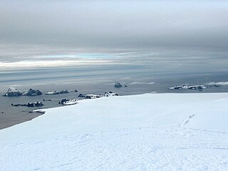
Barrientos Island is an ice-free island in the Aitcho group on the west side of English Strait in the South Shetland Islands, Antarctica. Extending 1.71 by 0.54 km, surface area 65 hectares. The area was visited by early 19th century sealers. Barrientos Island is a popular tourist site frequented by Antarctic cruise ships.

Contell Glacier is 1.2 nmi long and 0.4 nautical miles wide glacier on Hurd Peninsula, Livingston Island in the South Shetland Islands, Antarctica bounded by Atlantic Club Ridge to the northwest, Krum Rock to the north, Balkan Snowfield to the northeast, and Charrúa Ridge and Charrúa Gap to the south. It is crescent-shaped, running northwestwards in its upper course, then between Charrúa Ridge and Krum Rock turning west-southwestwards to flow into South Bay north of Johnsons Dock.

Barlow Island is a small ice-free island off the north coast of Smith Island in the South Shetland Islands, Antarctica extending 380 by 160 m, surface area 5.28 hectares.

Morris Rock is rising to 55 m (180 ft) in the northwest extremity of Aitcho group, English Strait in the South Shetland Islands, Antarctica. The area was visited by early 19th century sealers.

Stoker Island is a rocky island lying off the north coast of Greenwich Island in the South Shetland Islands, Antarctica. Extending 550 by 400 m, surface area 20 hectares. The area was visited by early 19th century sealers.

Ongley Island is a rugged rocky island lying off the north coast of Greenwich Island in the South Shetland Islands, Antarctica. Extending 1.35 km (0.84 mi) in west-northwest direction and 470 m (510 yd) wide, with a surface area of 44 hectares. The area was visited by early 19th century sealers.
Romeo Island is a rocky island lying off the north coast of Greenwich Island and west of Aitcho Islands in the South Shetland Islands, Antarctica. Extending 1.35 km (0.84 mi) in west-northwest direction and 470 m (510 yd) wide, with a surface area of 44 hectares. The area was visited by early 19th century sealers.
Pyramid Island is a conspicuous, pillar-shaped rocky island rising to 205 m (673 ft) off the north entrance to McFarlane Strait in the South Shetland Islands, Antarctica. Its surface area is 9 hectares. Cone Rock
(62°25′56.9″S60°06′08.3″W) is rising to 6 m (19.7 ft) 1.33 km (0.83 mi) south of the island,
2.03 km (1.26 mi) north-northwest of Meade Islands, 2.8 km (1.7 mi) northeast of Williams Point and
1.65 km (1.03 mi) east of Koshava Island, Zed Islands. The vicinity of Pyramid Island was visited on 19 February 1819 during the discovery of the South Shetlands by Captain William Smith in the British brig Williams, and later by early 19th century sealers.

Wood Island is a conspicuous rocky island in Hero Bay, Livingston Island in the South Shetland Islands, Antarctica lying southeast of Desolation Island and Miladinovi Islets and forming the south side of Blythe Bay. Surface area 14 hectares .) The area was frequented by early nineteenth century English and American sealers operating from Blythe Bay.
Craggy Island is a narrow island marked by crags, lying in Hero Bay, Livingston Island in the South Shetland Islands, Antarctica and forming the northeast side of Blythe Bay. Its surface area is 9 hectares .) The area was frequented by early nineteenth century English and American sealers operating from Blythe Bay.

Aspis Island is a small, low-lying, ice-free island rising to 15 metres (49 ft), easternmost in the Dunbar group off the northwest coast of Varna Peninsula, Livingston Island in the South Shetland Islands, Antarctica.
Skrino Rocks is the chain of rocks off the east coast of Robert Island in the South Shetland Islands, Antarctica, extending 570 m (623 yd) in east-west direction.

Vodoley Rock is the rock extending 220 m in northwest-southeast direction and 110 m wide in Barclay Bay on the west side of Ioannes Paulus II Peninsula on Livingston Island in the South Shetland Islands, Antarctica. The area was visited by early 19th century sealers operating on nearby Byers Peninsula and Cape Shirreff.


