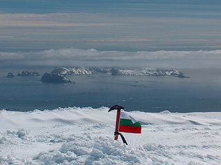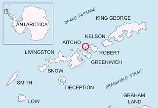
Archar Peninsula located in the North-Western extremity of Greenwich Island, Antarctica. The three km long peninsula is bounded by Razlog Cove to the North and McFarlane Strait to the South. Its western half is snow-free in summer. The peninsula is named after the settlement of Archar in Northwestern Bulgaria, successor of the ancient town of Ratiaria.

Krum Rock is a small nunatak rising to 208 metres on the southwest edge of Balkan Snowfield just north of Contell Glacier on Hurd Peninsula in eastern Livingston Island, one of the South Shetland Islands in Western Antarctica. The rock projects slightly above the ice sheet with some 3,000 square metres of rocky ground exposed on its northern slope in summer. Because of its location rather than prominence, it is a particularly important landmark in the course of field work carried out in the area.

Panega Glacier on Varna Peninsula, Livingston Island in the South Shetland Islands, Antarctica is situated southeast of the northeastern portion of Saedinenie Snowfield, south of Rose Valley Glacier, southwest of Debelt Glacier and north of lower Kaliakra Glacier. It drains the southeast slopes of Vidin Heights and flows into Moon Bay between Helis Nunatak and Perperek Knoll. The glacier extends 2 nautical miles in the southeast-northwest direction, and 1.6 nautical miles in the southwest-northeast direction. It is named after Zlatna Panega River in northern Bulgaria.

Rongel Reef, is a moraine reef in the Emona Anchorage in the eastern parts of Livingston Island in the South Shetland Islands, Antarctica. The reef emerged during a glacier retreat in the late 20th and early 21st centuries.

Rozhen Peninsula extends 9 km in the southwest direction towards Barnard Point, Livingston Island in the South Shetland Islands, Antarctica, and 8.8 km wide. It is bounded by False Bay and its segment Inept Cove to the west, Bransfield Strait to the southeast and Brunow Bay to the east. Its interior is occupied by the Friesland Ridge of Tangra Mountains.

Sea Lion Glacier is the site of an isolated 350 metres (1,150 ft) long glacier on Hurd Peninsula, eastern Livingston Island in the South Shetland Islands, Antarctica. It is located southwest of Hesperides Hill and northwest of Atlantic Club Ridge, separated from the latter by Sea Lion Tarn, and terminating on the South Bay coast.

Tundzha Glacier is a glacier on Livingston Island in the South Shetland Islands, Antarctica situated east-southeast of Berkovitsa Glacier, west of Saedinenie Snowfield, northwest of Pimpirev Glacier, north of Kamchiya Glacier and east-northeast of Verila Glacier. It is bounded by Snow Peak to the west, Teres Ridge to the east and the glacial divide between the Drake Passage and Bransfield Strait to the south. The glacier extends 7.5 nautical miles in east-west direction and 2.4 nautical miles in the north-south direction, and drains northwards into Hero Bay between Avitohol Point and Siddins Point.

Vergilov Rocks are a group of rocks off Bulgarian Beach on Hurd Peninsula in eastern Livingston Island in the South Shetland Islands, Antarctica, consisting of one main rock and two adjacent smaller ones submerging at high water.

Belozem Hill is the northeasternmost of a chain of hills along Bulgarian Beach on Hurd Peninsula in the east of Livingston Island, South Shetland Islands in Antarctica. The hill is boulder-clay capped with twin summits; the higher east-northeastern of them rising to 41 m. It is snow free in summer. The hill was mapped by the Spanish Servicio Geográfico del Ejército in 1991, and by Bulgaria in 1996 and 2005.

Desolation Island is one of the minor islands in the South Shetlands archipelago, Antarctica situated at the entrance to Hero Bay, Livingston Island. The island is V-shaped with its northern coast indented by Kozma Cove. Surface area 3.12 square kilometres (1.20 sq mi).

Ficheto Point is an ice-free point on the northeast coast of Varna Peninsula, Livingston Island, Antarctica forming the southeast side of the entrance to Dragon Cove. Channel Rock is lying in the adjacent northwestern part of McFarlane Strait, 1.3 km (0.81 mi) northeast of Ficheto Point and 920 m (1,010 yd) south-southwest of Meade Islands. The area was visited by 19th century sealers.

Telish Rock is the islet off the south coast of Livingston Island in the South Shetland Islands, Antarctica situated 400 m (437 yd) south of Elephant Point and 3 km (1.86 mi) northwest by west of Enchantress Rocks. Extending 300 by 180 m. The area was visited by early 19th century sealers.

Johnsons Glacier is the 1.8 km long and 2.3 km wide glacier on Hurd Peninsula, Livingston Island in the South Shetland Islands, Antarctica bounded by Charrúa Ridge and Charrúa Gap to the north, Napier Peak to the east, Mirador Hill to the southeast, Hurd Ice Cap to the southwest and Mount Reina Sofía to the west. It is draining northwestwards into Johnsons Dock. The glacier provides overland access from the Spanish base Juan Carlos Primero to the interior of the eastern Livingston Island.

Contell Glacier is 1.2 nmi long and 0.4 nautical miles wide glacier on Hurd Peninsula, Livingston Island in the South Shetland Islands, Antarctica bounded by Atlantic Club Ridge to the northwest, Krum Rock to the north, Balkan Snowfield to the northeast, and Charrúa Ridge and Charrúa Gap to the south. It is crescent-shaped, running northwestwards in its upper course, then between Charrúa Ridge and Krum Rock turning west-southwestwards to flow into South Bay north of Johnsons Dock.

Castillo Nunatak is a conspicuous rocky peak rising to 437 m on the glacial divide between Huntress Glacier and Balkan Snowfield on Hurd Peninsula in eastern Livingston Island in the South Shetland Islands, Antarctica. It is linked to Charrúa Ridge to the west Charrúa Gap and, via Willan Nunatak and Willan Saddle, to Burdick Ridge to the east-northeast. Castillo Nunatak is a prominent landmark in the Charrúa Gap area.

Morris Rock is rising to 55 m (180 ft) in the northwest extremity of Aitcho group, English Strait in the South Shetland Islands, Antarctica. The area was visited by early 19th century sealers.

Stoker Island is a rocky island lying off the north coast of Greenwich Island in the South Shetland Islands, Antarctica. Extending 550 by 400 m, surface area 20 hectares. The area was visited by early 19th century sealers.

Sally Rocks is a small group of rocks trending southwestwards in South Bay just off the west coast of Hurd Peninsula, Livingston Island in the South Shetland Islands, Antarctica.

Aspis Island is a small, low-lying, ice-free island rising to 15 metres (49 ft), easternmost in the Dunbar group off the northwest coast of Varna Peninsula, Livingston Island in the South Shetland Islands, Antarctica.

Eddystone Rocks is a group of two rocks lying to the northwest of Rugged Island off western Livingston Island in the South Shetland Islands, Antarctica.


