Vergilov Rocks

Last updated
Vergilov Rocks
Vergilov.jpg
Vergilov Rocks from Bulgarian Beach
Hurd-Peninsula-location-map.png
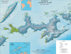
Location of Hurd Peninsula on Livingston Island in the South Shetland Islands
Antarctica relief location map.jpg
Red pog.svg
Vergilov Rocks
Antarctic Peninsula location map.svg
Red pog.svg
Vergilov Rocks
Geography
Location Antarctica
Coordinates 62°38′24″S60°22′12″W / 62.64000°S 60.37000°W / -62.64000; -60.37000
Archipelago South Shetland Islands
Administration
Administered under the Antarctic Treaty System
Demographics
Populationuninhabited

Vergilov Rocks (Vergilov Kamak ver-'gi-lov 'ka-m&k) are a group of rocks off Bulgarian Beach on Hurd Peninsula in eastern Livingston Island in the South Shetland Islands, Antarctica, consisting of one main rock and two adjacent smaller ones submerging at high water.

Contents

The rocks are named after Zlatil Vergilov, a member of the 1988 Bulgarian party on Livingston Island, base commander at St. Kliment Ohridski in the 1996-99 seasons.

Location

Topographic map of central-eastern Livingston Island featuring Vergilov Rocks Central-Eastern-Livingston-Map.png
Topographic map of central-eastern Livingston Island featuring Vergilov Rocks

The rocks are located at 62°38′24″S60°22′12″W / 62.64000°S 60.37000°W / -62.64000; -60.37000 which is 510 m (560 yd) northeast of Hespérides Point, 310 m (340 yd) west by south of Greenpeace Rock, and 100 m (110 yd) from the coast in front of the Bulgarian base (British mapping in 1968, Bulgarian mapping from a 1995-1996 topographic survey).

Topographic map of Livingston Island and Smith Island. Livingston-Island-Map-2010-15.png
Topographic map of Livingston Island and Smith Island.

Maps

See also

Notes

    Related Research Articles

    Bulgarian Beach

    Bulgarian Beach is a coast in the north part of Hurd Peninsula, eastern Livingston Island, extending 2.3 km from Hespérides Point to the southwest to Perunika Glacier to the northeast, and forming the southeast coast of Emona Anchorage.

    Emona Anchorage

    Emona Anchorage is a roughly square embayment, the internal part of South Bay, Livingston Island in the South Shetland Islands, Antarctica used as an anchorage for ships visiting the Bulgarian base St. Kliment Ohridski.

    Gurev Gap

    Gurev Gap is a flat ice-covered saddle of elevation 450 m extending 3 km in south-north direction between Hemus Peak and Gleaner Heights in eastern Livingston Island in the South Shetland Islands, Antarctica. The gap separates the glacial catchments of Kaliakra Glacier to the east, and Saedinenie Snowfield and Perunika Glacier to the west. It is part of the overland route from the St. Kliment Ohridski Base via the Balkan Snowfield, Rezen Saddle and Perunika Glacier to Varna Peninsula. The saddle was first trekked on 24 December 2004 by the Tangra 2004/05 Survey team from Camp Academia, and was named for Vasil Gurev, physicist at St. Kliment Ohridski in 1994/95 and subsequent seasons.

    Krum Rock nunatak in Livingston Island, South Shetland Islands, Antarctica

    Krum Rock is a small nunatak rising to 208 metres on the southwest edge of Balkan Snowfield just north of Contell Glacier on Hurd Peninsula in eastern Livingston Island, one of the South Shetland Islands in Western Antarctica. The rock projects slightly above the ice sheet with some 3,000 square metres of rocky ground exposed on its northern slope in summer. Because of its location rather than prominence, it is a particularly important landmark in the course of field work carried out in the area.

    Rezen Knoll

    Rezen Knoll is a knoll rising to 433 m in eastern Livingston Island in the South Shetland Islands, Antarctica. The knoll is bounded to the east, north and west by Perunika Glacier, and linked to Burdick Ridge by Rezen Saddle. The feature is 250 m wide, extending 500 m in east-west direction. Composed of lavas, with precipitous slopes except to the east. Partly ice-free height and western and northern slopes.

    Rezen Saddle

    Rezen Saddle is a geographical feature on Livingston Island in the South Shetland Islands, Antarctica. The 600 m long horseshoe-shaped flat saddle of elevation 420 m lies between Rezen Knoll and Burdick Ridge in eastern Livingston Island, affording overland access from Balkan Snowfield to upper Perunika Glacier and Bowles Ridge area.

    Rezovski Creek

    Rezovski Creek is a melt-water stream located on Livingston Island, Antarctica.

    Rozhen Peninsula

    Rozhen Peninsula extends 9 km in the southwest direction towards Barnard Point, Livingston Island in the South Shetland Islands, Antarctica, and 8.8 km wide. It is bounded by False Bay and its segment Inept Cove to the west, Bransfield Strait to the southeast and Brunow Bay to the east. Its interior is occupied by the Friesland Ridge of Tangra Mountains.

    Sea Lion Glacier glacier in Antarctica

    Sea Lion Glacier is the site of an isolated 350 metres (1,150 ft) long glacier on Hurd Peninsula, eastern Livingston Island in the South Shetland Islands, Antarctica. It is located southwest of Hesperides Hill and northwest of Atlantic Club Ridge, separated from the latter by Sea Lion Tarn, and terminating on the South Bay coast.

    St. Kliment Ohridski Base Antarctic base

    St. Kliment Ohridski Base is a Bulgarian Antarctic base on Livingston Island in the South Shetland Islands.

    Wörner Gap

    Wörner Gap is a flat saddle extending 3 km in the south-north direction between Friesland Ridge and Bowles Ridge in eastern Livingston Island in the South Shetland Islands, Antarctica. Its elevation decreases from 585 m in the south to 541 m in the middle, and 525 m in the north. The gap separates the glacial catchments of Perunika Glacier to the west and Huron Glacier to the east, and is linked to the east to Kuzman Knoll, a conspicuous landmark in the area. The gap is visited by field parties from St. Kliment Ohridski Base and Juan Carlos I Base and is subject to Spanish and Bulgarian glaciological studies.

    Hurd Peninsula

    Hurd Peninsula lies between South Bay and False Bay on the south coast of Livingston Island in the South Shetland Islands, Antarctica. The Spanish Juan Carlos I Antarctic Base and the Bulgarian St. Kliment Ohridski Base are situated on its west coast.

    Juan Carlos I Antarctic Base Antarctic base

    Juan Carlos I Antarctic Base, named after the king of Spain, Juan Carlos I, is a seasonal scientific station operated by Spain, opened in January 1988. Situated on Hurd Peninsula, Livingston Island in the South Shetland Islands, Antarctica.

    Burdick Ridge

    Burdick Ridge is a ridge rising to an elevation of 773 metres (2,536 ft) on Livingston Island in the South Shetland Islands. Extending for 1.9 kilometres (1.2 mi) between Orpheus Gate in the southeast and Rezen Saddle in the northwest, it is bounded by Perunika Glacier to the northeast and Balkan Snowfield to the southwest. It takes its name from its highest point, Burdick Peak.

    St. Ivan Rilski Chapel chapel on Livingston Island in the South Shetland Islands

    The St. Ivan Rilski Chapel at the Bulgarian base St. Kliment Ohridski on Livingston Island in the South Shetland Islands is the first Eastern Orthodox edifice in Antarctica, the southernmost Eastern Orthodox building of worship in the world, and one of eight churches on Antarctica.

    Charrúa Ridge

    Charrúa Ridge is an ice-free rocky ridge rising to 333 metres (1,093 ft) along the northeast coast of Johnsons Dock in Hurd Peninsula, Livingston Island, in the South Shetland Islands, Antarctica. It is narrow and precipitous, extending 700 metres (800 yd) in a west-northwest to east-southeast direction, with triple heights of elevation 322, 333 and 332 m respectively, and linked to Castillo Nunatak by Charrúa Gap. It surmounts Contell Glacier to the north, South Bay to the west, Johnsons Dock to the southwest and Johnsons Glacier to the south. It forms a prominent landmark in the area between the Spanish Antarctic base Juan Carlos I and the Bulgarian Antarctic base St. Kliment Ohridski.

    Sally Rocks Rocks in the South Shetland Islands, Antarctica

    Sally Rocks is a small group of rocks trending southwestwards in South Bay just off the west coast of Hurd Peninsula, Livingston Island in the South Shetland Islands, Antarctica.

    Raquelia Rocks Rocks in the South Shetland Islands, Antarctica

    Raquelia Rocks is a group of three adjacent rocks in eastern South Bay, Livingston Island in the South Shetland Islands, Antarctica formed by an offshoot of Atlantic Club Ridge halfway along the Zodiac boat route linking the Spanish Antarctic Base and the Bulgarian Antarctic Base on the island. The area was visited by early 19th century sealers operating from nearby Johnsons Dock.

    Pesyakov Hill

    Pesyakov Hill is the ice-free hill rising to 36 m next south-southwest of the 1988 buildings of St. Kliment Ohridski Base on Bulgarian Beach, Hurd Peninsula on Livingston Island in the South Shetland Islands, Antarctica. Surmounting Grand Lagoon to the west and southwest. Access to the hill is restricted to protect floral communities.

    Vergilov Ridge

    Vergilov Ridge is a submarine ridge in South Bay, Livingston Island in the South Shetland Islands, Antarctica. It extends 3.5 km in a southeast-northwest direction between the Vergilov Rocks and the opposite Pimpirev Beach at a depth of over 50 m, with depths exceeding 100 m on both sides of the ridge. It was formed as a frontal moraine of Perunika Glacier between the 13th and 17th centuries.

    References

    This article includes information from the Antarctic Place-names Commission of Bulgaria which is used with permission.