
Kabile Island is an Antarctic island extending 700 m (770 yd) in south-north direction and 450 m (490 yd) wide, situated off the north coast of Greenwich Island in the South Shetland Islands, Antarctica. It has a surface area of 19 hectares.

Makresh Rocks are a group of rocks situated 1.8 km (1.12 mi) northeast of Treklyano Island off the northeast coast of Robert Island, South Shetland Islands. Extending 600 m (656 yd) in west-southwest to east-northeast direction, and 270 m (295 yd) in northwest-southeast direction. The solitary Salient Rock62°21′24″S59°20′59″W is lying 1.73 km (1.07 mi) east of the midpoint of Makresh Rocks and 2 km (1.24 mi) northeast of Smirnenski Point.

Voluyak Rocks is a chain of rocks off the north coast of Greenwich Island in the South Shetland Islands, Antarctica situated 400 m (440 yd) north of Pavlikeni Point. Extending 1.9 km (1.2 mi) in southeast-northwest direction.

Okol Rocks is a group of rocks in the north of Aitcho Islands group on the west side of English Strait in the South Shetland Islands, Antarctica. The principal feature in the group is Lambert Island (62°22′16″S59°45′49″W).

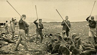
Barrientos Island is an ice-free island in the Aitcho group on the west side of English Strait in the South Shetland Islands, Antarctica. Extending 1.71 by 0.54 km, surface area 65 hectares. The area was visited by early 19th century sealers. Barrientos Island is a popular tourist site frequented by Antarctic cruise ships.
Ash Point is a rounded low ice-free point forming the southeast side of the entrance to Discovery Bay in the northeast of Greenwich Island in the South Shetland Islands, Antarctica with an adjacent ice-free area of 201 hectares. Letelier Bank is lying off Ash Point, while Bascopé Point is situated 460 m (503 yd)to the southwest, with the 1 km (0.62 mi) wide Rojas Cove indenting for 310 m (339 yd) the coast between that point and Guesalaga Peninsula. The area was visited by early 19th century sealers.

Cecilia Island is the ice-free southernmost island of the Aitcho group on the west side of English Strait in the South Shetland Islands, Antarctica. Extending 910 by 450 m, surface area 36 hectares. The area, visited by American and English sealers in the early 19th century, nowadays has become a popular tourist site frequented by Antarctic cruise ships.
Jorge Island is an ice-free island in the Aitcho group on the west side of English Strait in the South Shetland Islands, Antarctica. Extending 420 by 300 m, surface area 13 hectares. The area was visited by early 19th century sealers.

Ongley Island is a rugged rocky island lying off the north coast of Greenwich Island in the South Shetland Islands, Antarctica. Extending 1.35 km (0.84 mi) in west-northwest direction and 470 m (510 yd) wide, with a surface area of 44 hectares. The area was visited by early 19th century sealers.
Romeo Island is a rocky island lying off the north coast of Greenwich Island and west of Aitcho Islands in the South Shetland Islands, Antarctica. Extending 1.35 km (0.84 mi) in west-northwest direction and 470 m (510 yd) wide, with a surface area of 44 hectares. The area was visited by early 19th century sealers.
Cornwall Island is a low ice-free island off the north coast of Robert Island in the South Shetland Islands, Antarctica. Surface area 15 hectares. Mónica Rock is lying 1.65 km (1.03 mi) west of the island and 3.4 km (2.1 mi) north of Passage Rock, 2.84 km (1.76 mi) east of Table Island and 2 km (1.2 mi) south of Potmess Rocks. The area was visited by early 19th century sealers operating from nearby Clothier Harbour.
Labbé Point is a point projecting 600 m (660 yd) into the southwest part of Discovery Bay from Parvomay Neck, Greenwich Island in the South Shetland Islands, Antarctica with an adjacent ice-free area of 11 hectares. The point forms the northwest side of the entrance to Basullo Cove and the east side of the entrance to Vinett Cove. The small Basso Island is linked by a mainly submerged spit to the north side of Labbé Point.

Guesalaga Peninsula is a small, L-shaped, low-lying shingle covered peninsula on the east side of Discovery Bay, Greenwich Island in the South Shetland Islands, Antarctica forming the northwest coast of Iquique Cove and the north side of its entrance. The feature is projecting 700 m (766 yd) southwestwards and 300 m (328 yd) wide, with the narrow shingle Reyes Spit extending 400 m (437 yd) southwestwards from its west extremity Reyes Point into Discovery Bay. The Chilean Antarctic base Arturo Prat is situated on the peninsula.
Figueroa Point is an ice-free point at the northeast extremity of Greenwich Island in the South Shetland Islands, Antarctica forming the southeast side of the entrance to Galápagos Cove. Dovizio Rock is lying 190 m (210 yd) to the northeast, Ibar Rocks are centred 860 m (940 yd) to the southeast, Bonert Rock62°27′01.8″S59°42′58.3″W is 730 m (800 yd) to the south-southeast and Rosales Rocks62°26′57.5″S59°43′16.4″W are 500 m (550 yd) south by east of Figueroa Point. The area was visited by early 19th century sealers.

Chaos Reef is the confused area of breakers and shoal water in the north extremity of Aitcho Islands group on the west side of English Strait in the South Shetland Islands, Antarctica. The area was visited by early 19th century sealers operating from nearby Clothier Harbour.
Graovo Rocks is the group of rocks off the north coast of Robert Island in the South Shetland Islands, Antarctica, situated east of Lientur Rocks and southwest of Liberty Rocks, and extending 1.75 km (1.09 mi) in north-south direction and 750 m (820 yd) in east-west direction.
Milev Rocks is the group of rocks off the north coast of Robert Island in the South Shetland Islands, Antarctica, situated east of Henfield Rock, south-southwest of Orsoya Rocks and southwest of Mellona Rocks, and extending 1.5 km (0.93 mi) in east-west direction and 600 m (656 yd) in north-south direction.
Skrino Rocks is the chain of rocks off the east coast of Robert Island in the South Shetland Islands, Antarctica, extending 570 m (623 yd) in east-west direction.
Priboy Rocks is the group of rocks off the east coast of Robert Island in the South Shetland Islands, Antarctica, extending 1.65 km (1.03 mi) in east-west direction and 1.2 km (0.75 mi) in north-south direction.


