
Prespa Glacier on Rozhen Peninsula, Livingston Island in the South Shetland Islands, Antarctica is situated east-northeast of Tarnovo Ice Piedmont, east of the head of Charity Glacier, southeast of Ruen Icefall and southwest of Macy Glacier. It is bounded to the east by Needle Peak and Ludogorie Peak, to the northwest by St. Cyril Peak and St. Methodius Peak, and to the southwest by Shumen Peak and Yambol Peak, and flows southeastward into Bransfield Strait between Gela Point and Samuel Point. The feature extends 3.5 km in east-west direction and 2.5 km in north-south direction. The glacier is named after Prespa Peak in the Rhodope Mountains, Bulgaria.

Pasarel Island is an ice-free island in the Aitcho group on the west side of English Strait in the South Shetland Islands, Antarctica. The island is situated 900 m (980 yd) northwest of Barrientos Island, 1.35 km (0.84 mi) northeast of Sierra Island and 650 m (710 yd) southeast of Emeline Island. Extending 450 by 260 m. The area was visited by early 19th century sealers.

Onogur Islands is the group of nine islands and some islets and rocks adjacent to the northwest coast of Robert Island in the South Shetland Islands, Antarctica. The group is situated between Carlota Cove to the southwest and Clothier Harbour to the northeast, and 700 m (770 yd) southeast of Cornwall Island. Kovach Island and Grod Island, the largest two in the group, have a surface area of 11 hectares and 10 hectares respectively. The area was visited by early 19th century sealers based in Clothier Harbour.

Vardim Rocks are a group of rocks situated on the south side of Hell Gates, facing Devils Point in the southwest extremity of Byers Peninsula on Livingston Island in the South Shetland Islands, Antarctica. Extending 1.3 km (0.81 mi) in east-west direction. The two principal islets in the group, Demon and Sprite, are extending 420 by 400 m and 270 by 150 m respectively, with surface area of the former 9 hectares. The area was visited by early 19th century sealers.

Telish Rock is the islet off the south coast of Livingston Island in the South Shetland Islands, Antarctica situated 400 m (437 yd) south of Elephant Point and 3 km (1.86 mi) northwest by west of Enchantress Rocks. Extending 300 by 180 m. The area was visited by early 19th century sealers.

Zavala Island is an ice-free island in the Dunbar group off the northwest coast of Varna Peninsula on Livingston Island in the South Shetland Islands, Antarctica. It is extending 700 by 250 m, with surface area 14 hectares. The area was visited by early 19th century sealers.

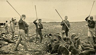
Barrientos Island is an ice-free island in the Aitcho group on the west side of English Strait in the South Shetland Islands, Antarctica. Extending 1.71 by 0.54 km, surface area 65 hectares. The area was visited by early 19th century sealers. Barrientos Island is a popular tourist site frequented by Antarctic cruise ships.
Skrino Rocks is the chain of rocks off the east coast of Robert Island in the South Shetland Islands, Antarctica, extending 570 m (623 yd) in east-west direction.
Alepu Rocks is the group of rocks off the east coast of Robert Island in the South Shetland Islands, Antarctica, situated in an area with a diameter of 380 m (416 yd).

Perivol Rock is the rock off Snow Island in the South Shetland Islands, Antarctica, extending 230 m in a southeast–northwest direction and 170 m wide.
Izgrev Passage is the 2.3 km wide passage separating Rogozen Island, Heywood Island and Pordim Islands from Cornwall Island, Onogur Islands and the northwest coast of Robert Island in the South Shetland Islands. The area was visited by early 19th century sealers.
Patresh Rock is the rock in Clothier Harbour on the northwest coast of Robert Island in the South Shetland Islands extending 270 m in southeast-northwest direction and 40 m wide. The area was visited by early 19th century sealers.
Redina Island is the ice-free island in the Onogur group off the northwest coast of Robert Island in the South Shetland Islands, Antarctica extending 280 m in east-west direction and 130 m wide. It is separated from Robert Island by a 20 m wide passage.
Oescus Island is the low ice-free island in the Onogur group off the northwest coast of Robert Island in the South Shetland Islands, Antarctica extending 380 m in southeast-northwest direction and 40 m wide. The feature comprises two parts connected by a spit, and is separated from Redina Island, Kovach Island and Leeve Island by passages 120 m, 160 m and 130 m wide respectively.
Vilare Island is the low ice-free island in the Onogur group off the northwest coast of Robert Island in the South Shetland Islands, Antarctica extending 130 m in east-west direction and 60 m wide. It is separated from Churicheni Island by a 20 m wide passage.
Churicheni Island is the ice-free island in the Onogur group off the northwest coast of Robert Island in the South Shetland Islands, Antarctica extending 230 m by 140 m. It is separated from Robert Island by a 100 m wide passage.
Osenovlag Island is the easternmost island in the Onogur group off the northwest coast of Robert Island in the South Shetland Islands, Antarctica. The feature is rocky, extending 510 m in southeast-northwest direction and 130 m wide. It is separated from Shipot Point by a 90 m wide passage. The area was visited by early 19th century sealers.
Svetulka Island is the northernmost island in the Onogur group off the northwest coast of Robert Island in the South Shetland Islands, Antarctica. The feature is rocky, extending 150 m by 90 m, and separated from Osenovlag Island by a 20 m wide passage. The area was visited by early 19th century sealers.

Nikudin Rock is the high, round rock of diameter 180 m and split in northeast-southwest direction, lying off the north coast of Greenwich Island in the South Shetland Islands. The area was visited by early 19th century sealers.
Klimash Passage is the 1.9 km wide passage in the South Shetland Islands between Table Island and Bowler Rocks on the northwest and Morris Rock and Chaos Reef, Aitcho Islands to the SE. The area was visited by early 19th century sealers.


