
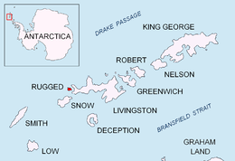
Smith Island is 20 miles (32 km) long and 5 miles wide, lying 45 miles (72 km) west of Deception Island in the South Shetland Islands of the British Antarctic Territory. Surface area 148 square kilometres (57 sq mi).

Rugged Island is an island 3 miles (4.8 km) long and 1 mile (1.6 km) wide, lying west of Livingston Island in the South Shetland Islands. Its surface area is 10.4 square kilometres (4.0 sq mi). The island's summit San Stefano Peak rises to 256 metres (840 ft) above sea level. Rugged Island is located at 62°38′S61°15′W. Rugged Island was known to both American and British sealers as early as 1820, and the name has been well established in international usage for over 100 years.

Kabile Island is an Antarctic island extending 700 m (770 yd) in south–north direction and 450 m (490 yd) wide, situated off the north coast of Greenwich Island in the South Shetland Islands, Antarctica. It has a surface area of 19 hectares.

Kaliakra Glacier is a glacier in northeastern Livingston Island, Antarctica extending 3.8 nautical miles in east-west direction and 4.3 nautical miles in north-south direction, and situated southeast of Saedinenie Snowfield, southwest of Panega Glacier, north of Struma Glacier and upper Huron Glacier, and northeast of Perunika Glacier. It is bounded by Melnik Ridge and Bowles Ridge to the south, by Hemus Peak, Gurev Gap, Gleaner Heights, Elhovo Gap, Leslie Hill, Leslie Gap and Radnevo Peak to the west, and Miziya Peak and Samuel Peak to the north. The glacier drains eastwards into Moon Bay south of Perperek Knoll and north of Sindel Point.
Kamchiya Glacier is located on Livingston Island in the South Shetland Islands, Antarctica situated south of the glacial divide between the Drake Passage and Bransfield Strait, and south of Tundzha Glacier, west-southwest of Pimpirev Glacier and east of Verila Glacier. The glacier extends 5 km along an east–west axis and is 2.2 km wide, draining into South Bay between Ereby Point and Memorable Beach.

Magura Glacier on the southeast side of Tangra Mountains on Livingston Island in the South Shetland Islands, Antarctica is located to the north of M'Kean Point, northeast of Srebarna Glacier, south of Iskar Glacier and southwest of Dobrudzha Glacier. It is bounded by Great Needle Peak to the west, Vitosha Saddle, Vihren Peak and Helmet Peak to the northwest, Plovdiv Peak and Shishman Peak to the north, and Devin Saddle and Kuber Peak to the northeast. The glacier extends 3.5 km in southwest-northeast direction and 1.9 km in northwest-southeast direction, and flows southeastward into Bransfield Strait.

Murgash Glacier is the 3.4 km long and 3.2 km wide glacier on Greenwich Island in the South Shetland Islands, Antarctica situated southeast of Yakoruda Glacier, south of Teteven Glacier, southwest of Traub Glacier and west-northwest of Bravo Glacier. It is bounded by Lloyd Hill on the northwest, Tile Ridge on the east and Hebrizelm Hill on the southeast, and drains southwards into Kramolin Cove in McFarlane Strait between Yovkov Point and Kaspichan Point.
Musala Glacier on Greenwich Island in the South Shetland Islands, Antarctica is situated northeast of Targovishte Glacier, east-northeast of Zheravna Glacier and southeast of Fuerza Aérea Glacier. It is bounded by St. Kiprian Peak to the south, Vratsa Peak to the southwest, central Breznik Heights to the west, and Ilarion Ridge bordering Hardy Cove to the northeast, extends 2 nautical miles in east-west direction and 1.2 nautical miles in north-south direction, and drains eastwards into Bransfield Strait north of Fort Point.
Perunika Glacier is an 8 km long and 3 km wide (average) roughly crescent-shaped glacier in eastern Livingston Island in the South Shetland Islands, Antarctica situated east of Pimpirev Glacier, south of Saedinenie Snowfield, southwest of Kaliakra Glacier, west of Huron Glacier, and north of Balkan Snowfield and the head of Huntress Glacier.
Struma Glacier is a glacier in eastern Livingston Island in the South Shetland Islands, Antarctica situated south of lower Kaliakra Glacier and north of Huron Glacier. Bounded by Melnik Ridge to the north, Yankov Gap to the west and Bowles Ridge to the south, it is 4.8 km long and 1.5 km wide, and flows eastwards into Moon Bay south of Sindel Point.

Vergilov Rocks are a group of rocks off Bulgarian Beach on Hurd Peninsula in eastern Livingston Island in the South Shetland Islands, Antarctica, consisting of one main rock and two adjacent smaller ones submerging at high water.

Desolation Island is one of the minor islands in the South Shetlands archipelago, Antarctica situated at the entrance to Hero Bay, Livingston Island. The island is V-shaped with its northern coast indented by Kozma Cove. Surface area 3.12 square kilometres (1.20 sq mi).

Miladinovi Islets is a group of two small rocky islands, 500 by 370 m, and 350 by 200 m respectively, situated 300 m (330 yd) south of Iratais Point on Desolation Island off the north coast of Livingston Island, Antarctica. The islands are separated from Desolation Island by Neck or Nothing Passage. The area was frequented by early nineteenth century English and American sealers operating from the adjacent Blythe Bay.

Maglizh Rocks are a group of rocks off the northwest coast of Smith Island, South Shetland Islands. The two adjacent principal rocks extending 460 m (503 yd) in east-west direction and 140 m (153 yd) wide are situated 300 m (328 yd) north of Lista Point, with the third major one, 300 by 100 m, situated 320 m (350 yd) northwest of them. Combined surface area 10.6 hectares. Bulgarian early mapping in 2009. Named after the town of Maglizh in southern Bulgaria.

Window Island is a small ice-free island off the north coast of Ray Promontory in the northwest of Byers Peninsula, Livingston Island in the South Shetland Islands, Antarctica. The island has a surface area of 23 hectares and rises to 72 m (236 ft). It was known to the early 19th century sealers operating on Byers Peninsula.

Sally Rocks is a small group of rocks trending southwestwards in South Bay just off the west coast of Hurd Peninsula, Livingston Island in the South Shetland Islands, Antarctica.

Aspis Island is a small, low-lying, ice-free island rising to 15 metres (49 ft), easternmost in the Dunbar group off the northwest coast of Varna Peninsula, Livingston Island in the South Shetland Islands, Antarctica.
Eddystone Rocks is a group of two rocks lying to the northwest of Rugged Island off western Livingston Island in the South Shetland Islands, Antarctica.

Zverino Island is the largest and westernmost island in the Meade group lying in the north entrance to McFarlane Strait in the South Shetland Islands, Antarctica. It is extending 1.2 km (0.75 mi) by 700 m (2,300 ft), with surface area of 48 hectares, and is snow-free in summer.
Kianida Reef is the 350 m long in east-west direction and 140 m wide, narrowing to the east rocky reef lying in Osogovo Bay, off the southeast extremity of Rugged Island in the South Shetland Islands. Its surface area is 4 ha. The area was visited by early 19th century sealers.


