
Signy Island is a small subantarctic island in the South Orkney Islands of Antarctica. It was named by the Norwegian whaler Petter Sørlle (1884–1933) after his wife, Signy Therese.
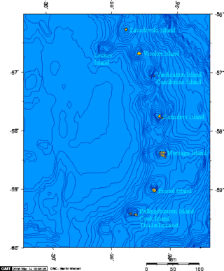
Cook Island is the central and largest island of the Southern Thule island group, part of the South Sandwich Islands in the far south Atlantic Ocean. Southern Thule was discovered by a British expedition under Captain James Cook in 1775. Cook Island was named for Cook by a Russian expedition under Fabian Gottlieb von Bellingshausen, which explored the South Sandwich islands in 1819–1820.

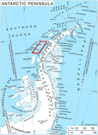
Adelaide Island is a large, mainly ice-covered island, 139 kilometres (75 nmi) long and 37 kilometres (20 nmi) wide, lying at the north side of Marguerite Bay off the west coast of the Antarctic Peninsula. The Ginger Islands lie off the southern end. Mount Bodys is the easternmost mountain on Adelaide Island, rising to over 1,220 m. The island lies within the Argentine, British and Chilean Antarctic claims.

Danco Island or Isla Dedo is an island off Antarctica, 2 kilometres (1 nmi) long lying in the southern part of Errera Channel, off the west coast of Graham Land. It was charted by the Belgian Antarctic Expedition under Adrien de Gerlache, 1897–1899. Danco Island was surveyed by the Falkland Islands Dependencies Survey from Norsel in 1955, and named by the UK Antarctic Place-names Committee for Emile Danco (1869–1898), a Belgian geophysicist and member of the Belgian Antarctic Expedition, who died on board Belgica in the Antarctic.
Renaud Island is an ice-covered island in the Biscoe Islands of Antarctica, 40 km (25 mi) long and from 6.4 to 16.1 km wide, lying between the Pitt Islands and Rabot Island. It is separated from the Pitt Islands to the northeast by Mraka Sound, and from Lavoisier Island to the southwest by Pendleton Strait.

Coronation Island is the largest of the South Orkney Islands, 25 nautical miles (46 km) long and from 3 to 8 nautical miles wide. The island extends in a general east–west direction, is mainly ice-covered and comprises numerous bays, glaciers and peaks, the highest rising to 1,265 metres (4,150 ft).

The Dailey Islands are a group of small volcanic islands lying off the coast of Victoria Land, 9 kilometres (5 nmi) northeast of Cape Chocolate, in the northern part of the ice shelf bordering McMurdo Sound. They were discovered by the British National Antarctic Expedition, 1901–04, under Robert Falcon Scott, and named for Fred E. Dailey, the expedition carpenter.

The Windmill Islands are an Antarctic group of rocky islands and rocks about 11.1 kilometres (6 nmi) wide, paralleling the coast of Wilkes Land for 31.5 kilometres (17 nmi) immediately north of Vanderford Glacier along the east side of Vincennes Bay. Kirkby Shoal is a small shoal area with depths of less than 18 metres (59 ft) extending about 140 metres (459 ft) westwards and SSW, about 3.4 kilometres (2.1 mi) from the summit of Shirley Island, Windmill Islands, and 0.24 kilometres (0.15 mi) NW of Stonehocker Point, Clark Peninsula.

Snow Hill Island is an almost completely snowcapped island, 33 km (21 mi) long and 12 km (7.5 mi) wide, lying off the east coast of the Antarctic Peninsula. It is separated from James Ross Island to the north-east by Admiralty Sound and from Seymour Island to the north by Picnic Passage. It is one of several islands around the peninsula known as Graham Land, which is closer to Chile, Argentina and South America than any other part of the Antarctic continent.
Blaiklock Island is a high and rugged, irregular-shaped island 17 kilometres (9 nmi) long, lying between Bigourdan Fjord and Bourgeois Fjord. It is separated from Pourquoi Pas Island by The Narrows and from the west coast of Graham Land by Jones Channel. The feature was partially surveyed in 1936 by the British Graham Land Expedition under Rymill, at which time it was charted as a promontory. It was determined to be an island in 1949 by Kenneth V. Blaiklock, a Falkland Islands Dependencies Survey (FIDS) surveyor for whom it is named.

The Willis Islands are a small archipelago to the west of South Georgia Island in the South Georgia Islands. They are 2 miles (3.2 km) west of Bird Island, separated by the Stewart Strait. They were discovered on 14 January 1775 by Captain James Cook and named for Cook's midshipman Thomas Willis, the crew member who first sighted them. The Willis Islands were charted in greater detail and individually named by Discovery Investigations (DI) personnel between 1926 and 1930.

Annenkov Island is an island in South Georgia and the South Sandwich Islands, to the west of the main island of South Georgia. The Pickersgill Islands are to its southeast. It is irregularly shaped and 4 miles (6.4 km) long and 650 m (2,130 ft) high, lying 8 miles (13 km) off the south-central coast of South Georgia.

Isbrecht Glacier is a small glacier flowing south from Thurston Island in Antarctica between Cox Glacier and Hale Glacier. It was named by the Advisory Committee on Antarctic Names after JoAnn Isbrecht of the United States Geological Survey (USGS), Flagstaff, Arizona, a satellite image processing specialist who was part of the USGS team that compiled the 1:5,000,000-scale Advanced Very High Resolution Radiometer maps of Antarctica and the 1:250,000-scale Landsat image maps of the Siple Coast area in the 1990s.

Endurance Glacier is a broad glacier north of Mount Elder, draining south-east to the south coast of Elephant Island in the South Shetland Islands of Antarctica, and is the main discharge glacier on the island. It was named by the UK Antarctic Place-Names Committee after HMS Endurance, which anchored off the glacier on several occasions in support of the Joint Services Expedition to Elephant Island, 1970–71.
East Ongul Island is an island in the Flatvaer Islands off of Antarctica. It is 2 kilometres (1 nmi) long, lying immediately east of the northern part of Ongul Island at the east side of the entrance of Lutzow-Holm Bay.

Clark Peninsula is a rocky peninsula, about 3 km (2 mi) long and wide, lying 5 km (3 mi) north-east of Australia's Casey Station at the north side of Newcomb Bay on the Budd Coast of Wilkes Land in Antarctica.

Posadowsky Glacier is a glacier about 9 nautical miles long, flowing north to Posadowsky Bay immediately east of Gaussberg. Posadowsky Bay is an open embayment, located just east of the West Ice Shelf and fronting on the Davis Sea in Kaiser Wilhelm II Land. Kaiser Wilhelm II Land is the part of East Antarctica lying between Cape Penck, at 87°43'E, and Cape Filchner, at 91°54'E, and is claimed by Australia as part of the Australian Antarctic Territory. Other notable geographic features in this area include Drygalski Island, located 45 mi NNE of Cape Filchner in the Davis Sea, and Mirny Station, a Russian scientific research station.
Dalmor Bank is a submarine bank with a least depth of about 80 metres (260 ft), lying off the east end of Dufayel Island in Ezcurra Inlet, King George Island. It was named by the Polish Antarctic Expedition after the expedition ship Dalmor, which first used the bank in 1977 as the best anchorage in the inlet.
Gdynia Point is the eastern point of Dufayel Island, lying in Ezcurra Inlet, Admiralty Bay, King George Island, in the South Shetland Islands. It was named in 1979 by the Polish Antarctic Expedition after Gdynia, Poland, a port city on the Baltic Sea.
The Henkes Islands are a group of small islands and rocks 4 kilometres (2 nmi) in extent, lying 2 kilometres (1 nmi) southwest of Avian Island, close off the southern extremity of Adelaide Island, Antarctica. The islands were discovered by the French Antarctic Expedition, 1908–10, under Jean-Baptiste Charcot, and named by him for one of the Dutch directors of the Magellan Whaling Company at Punta Arenas. Charcot applied the name to the scattered rocks and islands between Cape Adriasola and Cape Alexandra, and the name was restricted to the group described by the UK Antarctic Place-Names Committee (UKAPC) following definitive mapping by the British Antarctic Survey (BAS) in 1961 and the British Royal Navy Hydrographic Survey (BRNHS) in 1963. All of the islands in the group were named by UKAPC.


