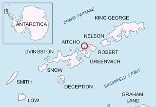
Tower Island is an Antarctic island 9 kilometres (5 nmi) long and 305 m (1,001 ft) high, lying 37 kilometres (20 nmi) north-east of Trinity Island and marking the north-east extent of Palmer Archipelago. The Pearl Rocks lie off its west coast.

Bear Island or Isla Teniente González is a rocky island lying 1.9 kilometres (1 nmi) west of Stonington Island in Marguerite Bay, off the coast of Graham Land. Bear Island was presumably known to the British Graham Land Expedition (BGLE) (1934-1937) and the United States Antarctic Service (USAS) Expedition (1939-1941), both based in the Stonington Island area. Bear Island was surveyed in 1947 by the Falkland Islands Dependencies Survey (FIDS), who named it for the USS Bear, flagship of the United States Antarctic Service (USAS) Expedition which visited this area in 1940.

Sierra Island is a narrow island which is marked by a series of small elevations throughout its length, lying 0.5 miles (0.8 km) northwest of Dee Island and north of Greenwich Island in the South Shetland Islands, Antarctica. Surface area 14 hectares.

The Zed Islands are a small group of islands, the westernmost rising to 290 m (951 ft), lying off the northeast extremity of Livingston Island in the South Shetland Islands, Antarctica comprising four islands: Esperanto Island, Phanagoria Island, Lesidren Island and Koshava Island, and the adjacent Dlagnya and Goritsa Rocks. The group is separated from Williams Point on Varna Peninsula, Livingston Island to the south by the 1.50 km (0.93 mi) wide Iglika Passage.

Express Island is a narrow craggy island, 1.23 kilometres (0.76 mi) long, lying close offshore of northwest Greenwich Island in the South Shetland Islands, Antarctica. It is situated due north of Greaves Peak, forming most of the east side of Razlog Cove. Surface area 29 hectares.

Aim Rocks is a group of rocks lying east of Cape Timblón in the middle of Morton Strait in the South Shetland Islands, Antarctica. The name, given by the United Kingdom Antarctic Place-Names Committee in 1961, is descriptive; these rocks in line are a guide for safe passage through the southern entrance of Morton Strait.

McFarlane Strait is a strait lying between Greenwich Island and Livingston Island, in the South Shetland Islands off Antarctica. It is 24 kilometres (13 nmi) long and 3 kilometres (1.6 nmi) wide. The name appears on an 1822 chart by Captain George Powell, a British sealer, and is now well established in international usage.

Morton Strait is the 9 km (4.9 nmi)-long and 6.2 km (3.3 nmi)-wide strait between Snow Island on the southwest and Rugged Island and Livingston Island on the northeast, in the South Shetland Islands, Antarctica. The Aim Rocks and Long Rock lie in the strait.

Telish Rock is the islet off the south coast of Livingston Island in the South Shetland Islands, Antarctica situated 400 m (437 yd) south of Elephant Point and 3 km (1.86 mi) northwest by west of Enchantress Rocks. Extending 300 by 180 m. The area was visited by early 19th century sealers.

Okol Rocks is a group of rocks in the north of Aitcho Islands group on the west side of English Strait in the South Shetland Islands, Antarctica. The principal feature in the group is Lambert Island (62°22′16″S59°45′49″W).

Emeline Island is a conspicuous rocky island rising to over 100 m (328 ft) in the Aitcho group on the west side of English Strait in the South Shetland Islands, Antarctica. The island extends 550 by 320 m with a surface area of 18 hectares. The area was visited by early 19th century seal hunters.

Table Island is a conspicuous flat-topped, rocky island lying north of Greenwich Island and north-northwest of the Aitcho group on the west side of English Strait in the South Shetland Islands, Antarctica. The island is rising to over 150 metres and extending 1.4 by 1 kilometre, with a surface area of 112 hectares. It is separated from Aitcho Islands to the south-southeast by the 1.9-kilometre (1.2-mile) wide Klimash Passage.

Fuerza Aérea Glacier is a glacier on Greenwich Island in the South Shetland Islands, Antarctica, extending 4.5 kilometres (2.8 mi) in a northeast–southwest direction and 2 kilometres (1.2 mi) in a southeast–northwest direction and draining the northwest slopes of the Breznik Heights to flow northwestwards into Discovery Bay.

Long Rock is a large rock extending 720 m (787 yd) in east-west direction, 180 m (197 yd) wide and rising to 13 m (42.7 ft) in the northeast of Morton Strait in the South Shetland Islands, Antarctica. The area was visited by early 19th century sealers operating on Byers Peninsula.

Figueroa Point is an ice-free point at the northeast extremity of Greenwich Island in the South Shetland Islands, Antarctica forming the southeast side of the entrance to Galápagos Cove. Dovizio Rock is lying 190 m (210 yd) to the northeast, Ibar Rocks are centred 860 m (940 yd) to the southeast, Bonert Rock62°27′01.8″S59°42′58.3″W is 730 m (800 yd) to the south-southeast and Rosales Rocks62°26′57.5″S59°43′16.4″W are 500 m (550 yd) south by east of Figueroa Point. The area was visited by early 19th century sealers.

Bowler Rocks is a group of rocks off the north coast of Greenwich Island in the South Shetland Islands, Antarctica lying southwest of Table Island and northwest of Aitcho Islands, and extending 1 km (0.62 mi) in east-west direction. The area was visited by early 19th-century sealers.

Chaos Reef is the confused area of breakers and shoal water in the north extremity of Aitcho Islands group on the west side of English Strait in the South Shetland Islands, Antarctica. The area was visited by early 19th century sealers operating from nearby Clothier Harbour.

Grace Rock is a rock in Bransfield Strait, Antarctica lying 1.72 kilometres (0.93 nmi) off the southeast coast of Nelson Island in the South Shetland Islands. It was named by the UK Antarctic Place-Names Committee in 1961 after the British sealing vessel Grace from Plymouth, which visited the South Shetland Islands in 1821–22.

Pig Rock is a rock, 65 m high, the largest of a group of rocks lying 1.9 kilometres (1 nmi) east of the east end of Nelson Island, in the South Shetland Islands. This rock, known to sealers in the area as early as 1821, was charted and named by DI personnel on the Discovery II in 1935.

Link Island is a small island at the outer (northern) margin of the Duroch Islands, approximately 6 kilometres (3 nmi) northwest of Halpern Point, Trinity Peninsula, Antarctica. The island was charted by the Chilean Antarctic Expedition, 1947–48, and called "Islote Sub-Teniente Ross" or "Islote Ross." The Advisory Committee on Antarctic Names named it after David A. Link, a field assistant with the University of Wisconsin geological party during reconnaissance of this area, 1960–61, this name avoiding possible confusion with James Ross Island.


