
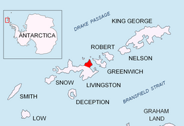
Ficheto Point is an ice-free point on the northeast coast of Varna Peninsula, Livingston Island, Antarctica forming the southeast side of the entrance to Dragon Cove. Channel Rock is lying in the adjacent northwestern part of McFarlane Strait, 1.3 km (0.81 mi) northeast of Ficheto Point and 920 m (1,010 yd) south-southwest of Meade Islands. The area was visited by 19th century sealers.

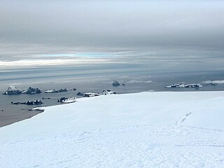
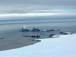
Williams Point is the point forming both the north extremity of Varna Peninsula and the northeast tip of Livingston Island in the South Shetland Islands, Antarctica. Separated from Zed Islands to the north by Iglika Passage.

Vardim Rocks are a group of rocks situated on the south side of Hell Gates, facing Devils Point in the southwest extremity of Byers Peninsula on Livingston Island in the South Shetland Islands, Antarctica. Extending 1.3 km (0.81 mi) in east-west direction. The two principal islets in the group, Demon and Sprite, are extending 420 by 400 m and 270 by 150 m respectively, with surface area of the former 9 hectares. The area was visited by early 19th century sealers.

Esperanto Island is the largest and northwesternmost island in the Zed group off the north coast of Varna Peninsula on Livingston Island in the South Shetland Islands, Antarctica. The island is ice-free, rocky, rising to 290 m (951 ft) and extending 950 by 900 m, with surface area 56 hectares. It is situated 70 m (77 yd) to the northwest of the neighbouring Phanagoria Island, and 2.7 km (1.7 mi) northwest of Williams Point on Livingston Island. The area was visited by early 19th century sealers.
Phanagoria Island is the third largest island in the Zed group off the north coast of Livingston Island in the South Shetland Islands, Antarctica. The island is ice-free, extending 700 by 500 m with surface area 20 hectares. Separated from the neighbouring Esperanto Island and Lesidren Island by channels 70 and 130 m wide respectively. Situated 2.1 km (1.3 mi) northwest of Williams Point. The area was visited by early 19th century sealers.
Lesidren Island is the second largest and southernmost island in the Zed group off the north coast of Varna Peninsula, Livingston Island in the South Shetland Islands, Antarctica. The island is ice-free, extending 800 by 600 m with surface area 33 hectares. Separated from the neighbouring Phanagoria Island and Koshava Island by channels 130 and 140 m wide respectively. The area was visited by early 19th century sealers.
Koshava Island is the easternmost island in the Zed group off Varna Peninsula, northeastern Livingston Island in the South Shetland Islands, Antarctica. The island is ice-free, extending 340 by 220 m. Situated on the west side of the north entrance to McFarlane Strait, 140 m (150 yd) northeast of Lesidren Island, and 1.9 km (1.2 mi) north of Williams Point on Livingston Island. The area was visited by early 19th century sealers.

Okol Rocks is a group of rocks in the north of Aitcho Islands group on the west side of English Strait in the South Shetland Islands, Antarctica. The principal feature in the group is Lambert Island (62°22′16″S59°45′49″W).
Iglika Passage is the passage between the Zed island group and Livingston Island in the South Shetland Islands, Antarctica, 1.53 km wide between Lesidren Island and Williams Point on Varna Peninsula, Livingston Island.

The Dunbar Islands are a small group of islands lying off Varna Peninsula southwest of Williams Point, the northeast extremity of Livingston Island in the South Shetland Islands, Antarctica comprising the islands of Aspis, Balsha, Melyane, Pogledets and Zavala, and several minor islets and rocks. The area was visited by early 19th century sealers.

Ash Point is a rounded low ice-free point forming the southeast side of the entrance to Discovery Bay in the northeast of Greenwich Island in the South Shetland Islands, Antarctica with an adjacent ice-free area of 201 hectares. Letelier Bank is lying off Ash Point, while Bascopé Point is situated 460 m (503 yd)to the southwest, with the 1 km (0.62 mi) wide Rojas Cove indenting for 310 m (339 yd) the coast between that point and Guesalaga Peninsula. The area was visited by early 19th century sealers.
The Meade Islands are a group of two large islands, Zverino Island and Cave Island, the minor Pisanitsa Island, and several rocks lying in the north entrance to McFarlane Strait, off Archar Peninsula, Greenwich Island in the South Shetland Islands, Antarctica. The surface areas of the first two islands are 48 hectares and 18 hectares. respectively. The area was visited by early 19th century sealers.
Morris Rock is a rock outcropping that rises to 55 m (180 ft) in the northwest extremity of the Aitcho group, English Strait in the South Shetland Islands, Antarctica. The area was visited by early 19th century sealers.
Pyramid Island is a conspicuous, pillar-shaped rocky island rising to 205 m (673 ft) off the north entrance to McFarlane Strait in the South Shetland Islands, Antarctica. Its surface area is 9 hectares. Cone Rock
(62°25′56.9″S60°06′08.3″W) is rising to 6 m (19.7 ft) 1.33 km (0.83 mi) south of the island,
2.03 km (1.26 mi) north-northwest of Meade Islands, 2.8 km (1.7 mi) northeast of Williams Point and
1.65 km (1.03 mi) east of Koshava Island, Zed Islands. The vicinity of Pyramid Island was visited on 19 February 1819 during the discovery of the South Shetlands by Captain William Smith in the British brig Williams, and later by early 19th century sealers.

Cornwall Island is a low ice-free island off the north coast of Robert Island in the South Shetland Islands, Antarctica. Surface area 15 hectares. Mónica Rock is lying 1.65 km (1.03 mi) west of the island and 3.4 km (2.1 mi) north of Passage Rock, 2.84 km (1.76 mi) east of Table Island and 2 km (1.2 mi) south of Potmess Rocks. The area was visited by early 19th century sealers operating from nearby Clothier Harbour.
Craggy Island is a narrow island marked by crags, lying in Hero Bay, Livingston Island in the South Shetland Islands, Antarctica and forming the northeast side of Blythe Bay. Its surface area is 9 hectares .) The area was frequented by early nineteenth century English and American sealers operating from Blythe Bay.

Sally Rocks is a small group of rocks trending southwestwards in South Bay just off the west coast of Hurd Peninsula, Livingston Island in the South Shetland Islands, Antarctica.
Eliza Rocks is a chain of rocks lying between Desolation Island and Zed Islands off the north coast of Livingston Island in the South Shetland Islands, Antarctica and extending 1 km in west-northwest direction. The area was visited by early 19th century sealers operating from Blythe Bay, Desolation Island.

Smolensk Strait is the strait in the South Shetland Islands, Antarctica separating Deception Island from Rozhen Peninsula on Livingston Island, 18.4 km wide between Macaroni Point to the southwest and Barnard Point to the northeast.
Dlagnya Rocks are the several contiguous rocks in Zed Islands off Varna Peninsula, Livingston Island in the South Shetland Islands extending 540 m in north-south direction and 60 m wide. The area was visited by early 19th century sealers.


