
Rongel Reef, is a moraine reef in the Emona Anchorage in the eastern parts of Livingston Island in the South Shetland Islands, Antarctica. The reef emerged during a glacier retreat in the late 20th and early 21st centuries.

Pasarel Island is an ice-free island in the Aitcho group on the west side of English Strait in the South Shetland Islands, Antarctica. The island is situated 900 m (980 yd) northwest of Barrientos Island, 1.35 km (0.84 mi) northeast of Sierra Island and 650 m (710 yd) southeast of Emeline Island. Extending 450 by 260 m. The area was visited by early 19th century sealers.
Bilyana Island is an ice-free island in the Aitcho group on the west side of English Strait in the South Shetland Islands, Antarctica. Extending 450 by 290 m, surface area 10 hectares. The area was visited by early 19th century sealers.

Barrientos Island is an ice-free island in the Aitcho group on the west side of English Strait in the South Shetland Islands, Antarctica. Extending 1.71 by 0.54 km, surface area 65 hectares. The area was visited by early 19th century sealers. Barrientos Island is a popular tourist site frequented by Antarctic cruise ships.

Cecilia Island is the ice-free southernmost island of the Aitcho group on the west side of English Strait in the South Shetland Islands, Antarctica. Extending 910 by 450 m, surface area 36 hectares. The area, visited by American and English sealers in the early 19th century, nowadays has become a popular tourist site frequented by Antarctic cruise ships.

Dee Island is the ice-free island lying between Greenwich Island and Aitcho Islands in the South Shetland Islands, Antarctica and is separated from Greenwich Island to the south by the 850 m (930 yd) wide Orión Passage and from Aitcho Islands to the northeast by the 1.1 km (0.68 mi) wide Villalón Passage. Extending 1.9 by 1.37 km, with the conspicuous Burro Peaks in the southeast rising to 190 m (620 ft), and surface area 197 hectares. The small Montufar Island and Araguez Island are lying 650 m (710 yd) east of Dee Island and 200 m (220 yd) east of its southern tip respectively. The area was visited by 19th century sealers.
Jorge Island is an ice-free island in the Aitcho group on the west side of English Strait in the South Shetland Islands, Antarctica. Extending 420 by 300 m, surface area 13 hectares. The area was visited by early 19th century sealers.
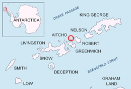
Table Island is a conspicuous flat-topped, rocky island lying north of Greenwich Island and north-northwest of the Aitcho group on the west side of English Strait in the South Shetland Islands, Antarctica. The island is rising to over 150 metres and extending 1.4 by 1 kilometre, with a surface area of 112 hectares. It is separated from Aitcho Islands to the south-southeast by the 1.9-kilometre (1.2-mile) wide Klimash Passage.
Morris Rock is rising to 55 m (180 ft) in the northwest extremity of Aitcho group, English Strait in the South Shetland Islands, Antarctica. The area was visited by early 19th century sealers.

Ongley Island is a rugged rocky island lying off the north coast of Greenwich Island in the South Shetland Islands, Antarctica. Extending 1.35 km (0.84 mi) in west-northwest direction and 470 m (510 yd) wide, with a surface area of 44 hectares. The area was visited by early 19th century sealers.
Romeo Island is a rocky island lying off the north coast of Greenwich Island and west of Aitcho Islands in the South Shetland Islands, Antarctica. Extending 1.35 km (0.84 mi) in west-northwest direction and 470 m (510 yd) wide, with a surface area of 44 hectares. The area was visited by early 19th century sealers.

Long Rock is a large rock extending 720 m (787 yd) in east-west direction, 180 m (197 yd) wide and rising to 13 m (42.7 ft) in the northeast of Morton Strait in the South Shetland Islands, Antarctica. The area was visited by early 19th century sealers operating on Byers Peninsula.

Eddystone Rocks is a group of two rocks lying to the northwest of Rugged Island off western Livingston Island in the South Shetland Islands, Antarctica.
Bowler Rocks is a group of rocks off the north coast of Greenwich Island in the South Shetland Islands, Antarctica lying southwest of Table Island and northwest of Aitcho Islands, and extending 1 km (0.62 mi) in east-west direction. The area was visited by early 19th-century sealers.

Vodoley Rock is the rock extending 220 m in northwest-southeast direction and 110 m wide in Barclay Bay on the west side of Ioannes Paulus II Peninsula on Livingston Island in the South Shetland Islands, Antarctica. The area was visited by early 19th century sealers operating on nearby Byers Peninsula and Cape Shirreff.
Nikudin Rock is the high, round rock of diameter 180 m and split in northeast-southwest direction, lying off the north coast of Greenwich Island in the South Shetland Islands. The area was visited by early 19th century sealers.


