
Nikopol Point is an ice-free point on the south coast of Byers Peninsula, Livingston Island in the South Shetland Islands, Antarctica projecting 650 m east-southeastwards into Bransfield Strait and linked by a spit to Vietor Rock to the south. The area was visited by early 19th century sealers who had dwellings at the foothills of nearby Sealer Hill.

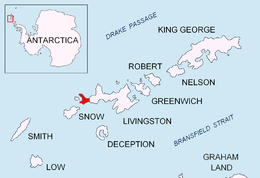
Morton Strait is the 9 km (4.9 nmi)-long and 6.2 km (3.3 nmi)-wide strait between Snow Island on the southwest and Rugged Island and Livingston Island on the northeast, in the South Shetland Islands, Antarctica. The Aim Rocks and Long Rock lie in the strait.

Chiprovtsi Point is a point projecting 400 m (440 yd) northwestwards from the north coast of Rugged Island off the west coast of Byers Peninsula of Livingston Island in the South Shetland Islands, Antarctica, and forming the east side of the entrance to Nishava Cove. It is extended further 400 m (440 yd) northwestwards by the group of Chiprovtsi Islets, which are centred at 62°36′52″S61°16′09″W and named in association with the point.
Sevar Point is a point on the south coast of Byers Peninsula on Livingston Island in the South Shetland Islands, Antarctica situated 1.9 km east-southeast of Devils Point, 2.71 km west of Nikopol Point, and 2.97 km northeast of Long Rock in Morton Strait. It is surmounted by Wasp Hill on the north-northeast, Sealer Hill on the east-northeast, and forms the east side of the entrance to Raskuporis Cove.
Dometa Point is a point in the middle part of South Beaches on Byers Peninsula, Livingston Island in the South Shetland Islands, Antarctica. It is situated 4.3 km west-northwest of Rish Point, 1.2 km southwest of Negro Hill, 4.6 km southeast of Chester Cone, and 4.2 km east-northeast of Nikopol Point. Fontus Lake is centred 600 m northeast of the point.
Vardim Rocks are a group of rocks situated on the south side of Hell Gates, facing Devils Point in the southwest extremity of Byers Peninsula on Livingston Island in the South Shetland Islands, Antarctica. Extending 1.3 km (0.81 mi) in east-west direction. The two principal islets in the group, Demon and Sprite, are extending 420 by 400 m and 270 by 150 m respectively, with surface area of the former 9 hectares. The area was visited by early 19th century sealers.
Window Island is a small ice-free island off the north coast of Ray Promontory in the northwest of Byers Peninsula, Livingston Island in the South Shetland Islands, Antarctica. The island has a surface area of 23 hectares and rises to 72 m (236 ft). It was known to the early 19th century sealers operating on Byers Peninsula.
Point Smellie is a small steep-sided headland extending into Osogovo Bay from President Beaches on Byers Peninsula, Livingston Island in the South Shetland Islands, Antarctica and dominated by Smellie Hill.
Laager Point is a conspicuous headland extending out from President Beaches on Byers Peninsula, Livingston Island in the South Shetland Islands, Antarctica facing Astor Island. It forms the southeast entrance point for New Plymouth harbour and the northeast entrance point for Osogovo Bay. Naiad Lake is situated on the southwest side of the point and Pistiros Lake is centred 900 m east of it. The area was visited by 19th century sealers.
Ocoa Point is a steep headland backed by raised beach terraces at the head of New Plymouth harbour in Byers Peninsula, Livingston Island in the South Shetland Islands, Antarctica. The area was visited by 19th century sealers.
Negro Hill is a conspicuous rocky hill, double-peaked with a small tarn in between, rising to 100 m at South Beaches on Byers Peninsula, Livingston Island in the South Shetland Islands, Antarctica. It surmounts Fontus Lake on the south. The area was visited by 19th-century sealers.
Usnea Plug is a volcanic plug, 30 m from base to summit, rising to 117 m in the interior of Byers Peninsula, Livingston Island in the South Shetland Islands, Antarctica. The area was known to 19th century sealers.
Sealer Hill is a hill rising to 70 m in the southwest part of Byers Peninsula, Livingston Island in the South Shetland Islands, Antarctica. It surmounts Nikopol Point and Sevar Point to the east-southeast and west-southwest, respectively. The area was inhabited by 19th century sealers.
Long Rock is a large rock extending 720 m (787 yd) in east–west direction, 180 m (197 yd) wide and rising to 13 m (42.7 ft) in the northeast of Morton Strait in the South Shetland Islands, Antarctica. The area was visited by early 19th century sealers operating on Byers Peninsula.

Frederick Rocks is a group of rocks lying in Barclay Bay on the north side of Livingston Island in the South Shetland Islands, Antarctica. The area was visited by early 19th century sealers operating on nearby Byers Peninsula.
Stackpole Rocks is a group of rocks, the largest of them linked by a spit to the east extremity of South Beaches in Byers Peninsula, Livingston Island in the South Shetland Islands, Antarctica. The area was visited by early 19th century sealers.
Cutler Stack is a conspicuous sea stack extending 170 by 150 m and rising to 16 m (52 ft), lying off Ivanov Beach in the south of Barclay Bay, western Livingston Island in the South Shetland Islands, Antarctica. The area was visited by early 19th century sealers.

Vodoley Rock is the rock extending 220 m (720 ft) in northwest–southeast direction and 110 m (360 ft) wide in Barclay Bay on the west side of Ioannes Paulus II Peninsula on Livingston Island in the South Shetland Islands, Antarctica. The area was visited by early 19th century sealers operating on nearby Byers Peninsula and Cape Shirreff.
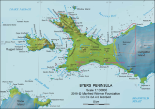
Naiad Lake is the roughly rectangular 230 m-long (250 yd) in south-north direction and 150 m-wide (160 yd) lake on President Beaches, Byers Peninsula on Livingston Island in the South Shetland Islands, Antarctica. It has a surface area of 2.98 ha, and is separated from Osogovo Bay waters by a 12-to-90 m-wide (10-to-100 yd) strip of land. The area was visited by early 19th century sealers.
Acheron Lake is the B-shaped 315 m long in southwest-northeast direction and 186 m wide lake on President Beaches, Byers Peninsula on Livingston Island in the South Shetland Islands, Antarctica. It has a surface area of 4.4 ha, and is separated from Osogovo Bay waters by a 10 to 25 m wide strip of land. Lucifer Crags surmount the lake on the southwest. The area was visited by early 19th century sealers.


