Chapman Rocks

Last updated
Chapman Rocks
Livingston-Island-location-map.png
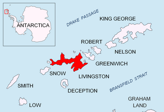
Location of Livingston Island in the South Shetland Islands
Antarctic Peninsula location map.svg
Red pog.svg
Chapman Rocks
Location of Chapman Rocks
Antarctica relief location map.jpg
Red pog.svg
Chapman Rocks
Chapman Rocks (Antarctica)
Geography
Location Antarctica
Coordinates 62°29′42.8″S60°28′55.4″W / 62.495222°S 60.482056°W / -62.495222; -60.482056
Archipelago South Shetland Islands
Administration
Administered under the Antarctic Treaty System
Demographics
Populationuninhabited

Chapman Rocks is a group of rocks in central Hero Bay on the north side of Livingston Island in the South Shetland Islands, Antarctica. The area was visited by early 19th century sealers operating from nearby Blythe Bay.

Contents

The feature is named after Thomas Chapman, English trunk-maker of Southwark who in 1795 discovered a method of processing fur seal skins for use in the hat trade, thus initiating the industry in London.

Location

The rocks are located at 62°29′42.8″S60°28′55.4″W / 62.495222°S 60.482056°W / -62.495222; -60.482056 which is 6.05 km (3.76 mi) north-northwest of Siddins Point, 6.03 km (3.75 mi) northeast of Lynx Rocks, 12.09 km (7.51 mi) east of Black Point, 7.97 km (4.95 mi) west-southwest of Iratais Point, Desolation Island, 7.6 km (4.7 mi) west-southwest of Miladinovi Islets, 7.28 km (4.52 mi) west by south of Koynare Rocks and 5.23 km (3.25 mi) northwest of Belchin Rock (British mapping in 1968, Chilean in 1971, Argentine in 1980, and Bulgarian in 2009).

See also

Maps

Related Research Articles

<span class="mw-page-title-main">Rongel Reef</span> Reef in South Shetlands Islands, Antarctica

Rongel Reef, is a moraine reef in the Emona Anchorage in the eastern parts of Livingston Island in the South Shetland Islands, Antarctica. The reef emerged during a glacier retreat in the late 20th and early 21st centuries.

<span class="mw-page-title-main">Indian Rocks</span>

Indian Rocks is a group of rocks in eastern Hero Bay on the north side of Livingston Island in the South Shetland Islands, Antarctica. The area was visited by early 19th century sealers operating from Blythe Bay.

<span class="mw-page-title-main">Koynare Rocks</span> Rocks in the South Shetland Islands, Antarctica

Koynare Rocks are a small group of rocks in Hero Bay off the north coast Livingston Island in the South Shetland Islands, Antarctica situated 7.5 km (4.66 mi) northeast of Siddins Point, 5.3 km (3.29 mi) northwest of Bezmer Point, and 1.4 km (0.87 mi) south of Miladinovi Islets. The area was visited by early 19th century sealers.

<span class="mw-page-title-main">Ongley Island</span> Island in the South Shetland Islands, Antarctica

Ongley Island is a rugged rocky island lying off the north coast of Greenwich Island in the South Shetland Islands, Antarctica. Extending 1.35 km (0.84 mi) in west-northwest direction and 470 m (510 yd) wide, with a surface area of 44 hectares. The area was visited by early 19th century sealers.

<span class="mw-page-title-main">Romeo Island</span> Island

Romeo Island is a rocky island lying off the north coast of Greenwich Island and west of Aitcho Islands in the South Shetland Islands, Antarctica. Extending 1.35 km (0.84 mi) in west-northwest direction and 470 m (510 yd) wide, with a surface area of 44 hectares. The area was visited by early 19th century sealers.

<span class="mw-page-title-main">Wood Island (Livingston Island)</span> Island in the South Shetland Islands, Antarctica

Wood Island is a conspicuous rocky island in Hero Bay, Livingston Island in the South Shetland Islands, Antarctica lying southeast of Desolation Island and Miladinovi Islets and forming the south side of Blythe Bay. Surface area 14 hectares .) The area was frequented by early nineteenth century English and American sealers operating from Blythe Bay.

<span class="mw-page-title-main">Craggy Island (Livingston Island)</span>

Craggy Island is a narrow island marked by crags, lying in Hero Bay, Livingston Island in the South Shetland Islands, Antarctica and forming the northeast side of Blythe Bay. Its surface area is 9 hectares .) The area was frequented by early nineteenth century English and American sealers operating from Blythe Bay.

<span class="mw-page-title-main">Labbé Point</span>

Labbé Point is a point projecting 600 m (660 yd) into the southwest part of Discovery Bay from Parvomay Neck, Greenwich Island in the South Shetland Islands, Antarctica with an adjacent ice-free area of 11 hectares. The point forms the northwest side of the entrance to Basullo Cove and the east side of the entrance to Vinett Cove. The small Basso Island is linked by a mainly submerged spit to the north side of Labbé Point.

<span class="mw-page-title-main">Guesalaga Peninsula</span> Peninsula in the South Shetland Islands, Antarctica

Guesalaga Peninsula is a small, L-shaped, low-lying shingle covered peninsula on the east side of Discovery Bay, Greenwich Island in the South Shetland Islands, Antarctica forming the northwest coast of Iquique Cove and the north side of its entrance. The feature is projecting 700 m (766 yd) southwestwards and 300 m (328 yd) wide, with the narrow shingle Reyes Spit extending 400 m (437 yd) southwestwards from its west extremity Reyes Point into Discovery Bay. The Chilean Antarctic base Arturo Prat is situated on the peninsula.

<span class="mw-page-title-main">Lynx Rocks</span> Rocks in the South Shetland Islands, Antarctica

Lynx Rocks is a group of rocks in southwestern Hero Bay on the north side of Livingston Island in the South Shetland Islands, Antarctica. The area was visited by early 19th century sealers operating from nearby Blythe Bay.

<span class="mw-page-title-main">Eliza Rocks</span> Group of rocks in the South Shetland Islands, Antarctica

Eliza Rocks is a chain of rocks lying between Desolation Island and Zed Islands off the north coast of Livingston Island in the South Shetland Islands, Antarctica and extending 1 km in west-northwest direction. The area was visited by early 19th century sealers operating from Blythe Bay, Desolation Island.

<span class="mw-page-title-main">Frederick Rocks</span> Group of rocks in the South Shetland Islands, Antarctica

Frederick Rocks is a group of rocks lying in Barclay Bay on the north side of Livingston Island in the South Shetland Islands, Antarctica. The area was visited by early 19th century sealers operating on nearby Byers Peninsula.

<span class="mw-page-title-main">Hetty Rock</span> Rock in the South Shetland Islands, Antarctica

Hetty Rock is the largest of several rocks in Walker Bay off John Beach in western Livingston Island in the South Shetland Islands, Antarctica. The area was visited by early 19th century sealers.

<span class="mw-page-title-main">Stackpole Rocks</span> Group of rocks in Antarctica

Stackpole Rocks is a group of rocks, the largest of them linked by a spit to the east extremity of South Beaches in Byers Peninsula, Livingston Island in the South Shetland Islands, Antarctica. The area was visited by early 19th century sealers.

<span class="mw-page-title-main">Eddystone Rocks (South Shetland Islands)</span> Group of two rocks in the South Shetland Islands, Antarctica.

Eddystone Rocks is a group of two rocks lying to the northwest of Rugged Island off western Livingston Island in the South Shetland Islands, Antarctica.

<span class="mw-page-title-main">Chaos Reef</span>

Chaos Reef is the confused area of breakers and shoal water in the north extremity of Aitcho Islands group on the west side of English Strait in the South Shetland Islands, Antarctica. The area was visited by early 19th century sealers operating from nearby Clothier Harbour.

<span class="mw-page-title-main">Lientur Rocks</span> Rocks in the South Shetland Islands, Antarctica

Lientur Rocks is a group of prominent adjacent rocks lying off the north coast of Robert Island in the South Shetland Islands, Antarctica and extending 660 m (722 yd) in east–west direction and 320 m (350 yd) in north–south direction. The area was visited by early 19th-century sealers operating from nearby Clothier Harbour.

<span class="mw-page-title-main">Milev Rocks</span>

Milev Rocks is the group of rocks off the north coast of Robert Island in the South Shetland Islands, Antarctica, situated east of Henfield Rock, south-southwest of Orsoya Rocks and southwest of Mellona Rocks, and extending 1.5 km (0.93 mi) in east-west direction and 600 m (656 yd) in north-south direction.

<span class="mw-page-title-main">Vodoley Rock</span> Rock in the South Shetland Islands, Antarctica

Vodoley Rock is the rock extending 220 m (720 ft) in northwest–southeast direction and 110 m (360 ft) wide in Barclay Bay on the west side of Ioannes Paulus II Peninsula on Livingston Island in the South Shetland Islands, Antarctica. The area was visited by early 19th century sealers operating on nearby Byers Peninsula and Cape Shirreff.

<span class="mw-page-title-main">Mihaylovski Cove</span>

Mihaylovski Cove is the 5 km wide cove indenting for 1.3 km the northwest coast of South Bay in Livingston Island, Antarctica that is entered west of Ereby Point and east of Lukovo Point, and has its head fed by Kamchiya Glacier. The area was known to early 19th century sealers who operated from nearby Johnsons Dock. The feature is named after the brothers Petar Mihaylovski, physician at St. Kliment Ohridski base during the 2007/08 and subsequent seasons, and Hristo Mihaylovski, engineer in the national Antarctic campaign during 2015/16 and subsequent seasons.

References

    Topographic map of Livingston Island, Greenwich, Robert, Snow and Smith Islands. Livingston-Island-Map-2010.jpg
    Topographic map of Livingston Island, Greenwich, Robert, Snow and Smith Islands.