
Signy Island is a small subantarctic island in the South Orkney Islands of Antarctica. It was named by the Norwegian whaler Petter Sørlle (1884–1933) after his wife, Signy Therese.

The Antarctic Sound is a body of water about 30 nautical miles long and from 7 to 12 nautical miles wide, separating the Joinville Island group from the northeast end of the Antarctic Peninsula. The sound was named by the Swedish Antarctic Expedition under Otto Nordenskjöld for the expedition ship Antarctic which in 1902, under the command of Carl Anton Larsen, was the first vessel to navigate it. Since 1998 cruise ships have been visiting the area.

Tower Island is an Antarctic island 9 kilometres (5 nmi) long and 305 m (1,001 ft) high. It marks the north-east extent of Palmer Archipelago. It lies 37 kilometres (20 nmi) north-east of Trinity Island, separated by Gilbert Strait. Both islands are separated from the Davis Coast to the south by Orléans Strait, running northeast–southwest. The Pearl Rocks lie off the West Coast of Tower Island.

Brabant Island is the second largest island of the Palmer Archipelago within the British Antarctic Territory, lying between Anvers Island and Liège Island. Brabant Island is 59 km (37 mi) long north-south, 30 km (19 mi) wide, and rises to 2,520 m (8,268 ft) in Mount Parry. The interior of the island is occupied by two mountain ranges, Solvay Mountains in its southern part and Stribog Mountains in its central and northern parts.

Palmer Archipelago, also known as Antarctic Archipelago, Archipiélago Palmer, Antarktiske Arkipel or Palmer Inseln, is a group of islands off the northwestern coast of the Antarctic Peninsula. It extends from Tower Island in the north to Anvers Island in the south. It is separated by the Gerlache and Bismarck straits from the Antarctic Peninsula and Wilhelm Archipelago, respectively. The archipelago is in the British, Chilean, and Argentine Claims.
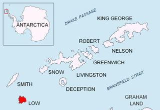
Bransfield Strait or Fleet Sea is a body of water about 100 kilometres (60 mi) wide extending for 300 miles (500 km) in a general northeast – southwest direction between the South Shetland Islands and the Antarctic Peninsula.
Hughes Bay is a bay lying between Cape Sterneck and Cape Murray along the west coast of the Antarctic Peninsula.

Shambles Glacier is a steep glacier 4 miles (6 km) long and 6 miles (10 km) wide, with very prominent hummocks and crevasses, flowing east between Mount Bouvier and Mount Mangin into Stonehouse Bay on the east side of Adelaide Island. It is the island's largest glacier, and provides an eastern outlet from the giant Fuchs Ice Piedmont which covers the entire western two-thirds of the island. In doing so, Shambles Glacier provides the largest 'gap' in Adelaide Island's north–south running mountain chain.
East Ongul Island is an island in the Flatvaer Islands off of Antarctica. It is 2 kilometres (1 nmi) long, lying immediately east of the northern part of Ongul Island at the east side of the entrance of Lutzow-Holm Bay.
Two Hummock Island is an ice-covered island, 5 nautical miles long in a north–south direction, conspicuous for its two rocky summits 670 metres (2,200 ft) high, lying 5 nautical miles southeast of Liège Island in the Palmer Archipelago.

Aim Rocks is a group of rocks lying east of Cape Timblón in the middle of Morton Strait in the South Shetland Islands, Antarctica. The name, given by the United Kingdom Antarctic Place-Names Committee in 1961, is descriptive; these rocks in line are a guide for safe passage through the southern entrance of Morton Strait.

Mount Friesland is a mountain rising to 1,700.2 metres (5,578 ft) in the homonymous Friesland Ridge, one of the two summits of Tangra Mountains and Livingston Island in the South Shetland Islands, Antarctica along with neighbouring St. Boris Peak. Its north rib is connected to Pliska Ridge by Nesebar Gap on the west, and to Bowles Ridge by Wörner Gap on the north. On the east, Mount Friesland is connected to Presian Ridge and further on to Catalunyan Saddle and Lyaskovets Peak. On the south-southwest, it is connected by a short saddle to ‘The Synagogue’ a sharp-peaked rock-cored ice formation abutting St. Boris Peak. The peak is heavily glaciated and crevassed, surmounting Huntress Glacier to the west, Perunika Glacier to the north-northwest, Huron Glacier to the northeast and Macy Glacier to the southeast. The local weather is notoriously unpleasant and challenging; according to the seasoned Antarctic mountaineer Damien Gildea who climbed in the area, 'just about the worst weather in the world'.
Morton Strait is the 9-kilometre-long (4.9 nmi) and 6.2-kilometre-wide (3.3 nmi) strait between Snow Island on the southwest and Rugged Island and Livingston Island on the northeast, in the South Shetland Islands, Antarctica. The Aim Rocks and Long Rock lie in the strait.

Duff Point is a point on Archar Peninsula forming the western extremity of Greenwich Island, in the South Shetland Islands, Antarctica. The name Duffs Straits was applied to McFarlane Strait by James Weddell in 1820–23, after Captain Norwich Duff under whom Weddell served in HMS Espoir in 1814. The name Duff Point was given by the UK Antarctic Place-Names Committee in 1961 in order to preserve Weddell's name in the area; this point forms the northeast entrance to McFarlane Strait.
The Flatvaer Islands, also known as the Ongul Islands, are a group of small islands lying at the east side of the entrance of Lützow-Holm Bay, 4 km from the coastline of Antarctica. They were mapped by Norwegian cartographers from air photos taken by the Lars Christensen Expedition (LCE), 1936–37. Many of the islands and their features were subsequently named by members of the Japanese Antarctic Research Expedition (JARE); unless otherwise noted, features noted in this article were named by JARE.

Cave Island is an island marked by a large cavern in its south side, which is the second largest of the Meade Islands lying in the north entrance to McFarlane Strait, off Archar Peninsula on Greenwich Island in the South Shetland Islands. It is separated from neighbouring Zverino Island to the west-southwest by the 110 m wide Glogovo Passage.
Jameson Point is a small headland on the north side of the entrance to Malina Cove, situated 6.3 km (3.9 mi) north of Cape Garry on the west side of Low Island, in the South Shetland Islands of Antarctica. It was roughly charted by the French Antarctic Expedition, 1908–10. The point was photographed from the air by the Falkland Islands and Dependencies Aerial Survey Expedition, 1955–57, and more accurately delineated from these photos by the Falkland Islands Dependencies Survey in 1959. The name "Jameson Island" was applied to Low Island by James Weddell in 1820–23, and Jameson Point has been approved for this point to preserve Weddell's name on Low Island.
Murray Island is an island 6 nautical miles long lying at the south-west side of Hughes Bay, off the west coast of Graham Land, Antarctica.
Hoseason Island is an island 6 nautical miles long and 3 nautical miles wide, lying 20 nautical miles west of Trinity Island in the Palmer Archipelago, Antarctica.
Maxwell Bay, also called Fildes Bay and Guardia Nacional Bay is a bay 19 km (12 mi) long, lying between King George Island and Nelson Island, in the South Shetland Islands of Antarctica. The main entrance to the bay is at the south-east side and is wide open; Fildes Strait on the north-west side is encumbered by rocks and is only navigable by boats. The name "Maxwells Straits" was given to this bay and to Fildes Strait by British sealing captain James Weddell in 1822–24, for Lieutenant Francis Maxwell who had served with Weddell in 1813–14. The name was altered and limited to the feature here described by the UK Antarctic Place-Names Committee in 1960.


