
Valchedram Island is an ice-free island off the north coast of Livingston Island in the South Shetland Islands, Antarctica extending 280 m (310 yd) in southeast-northwest direction. The feature is named after the town of Valchedram in northwestern Bulgaria.

Maglizh Rocks are a group of rocks off the northwest coast of Smith Island, South Shetland Islands. The two adjacent principal rocks, extending 460 m (503 yd) in east-west direction and 140 m (153 yd) wide are situated 300 m (328 yd) north of Lista Point, with the third major one, 300 by 100 m, situated 320 m (350 yd) northwest of them. The rocks have a combined surface area of 10.6 hectares. The rocks are named after the town of Maglizh in southern Bulgaria.
Dalgopol Glacier is a 3.4 kilometres (2.1 mi) long glacier draining the northwest slopes of Imeon Range on Smith Island in the South Shetland Islands, Antarctica. It is situated northeast of Vetrino Glacier and southwest of Kongur Glacier, and flows north of Mount Pisgah and northwest of Mezek Peak into Drake Passage. Bulgarian early mapping in 2009. The glacier is named after the town of Dalgopol in northeastern Bulgaria.
Vetrino Glacier is a 3.2 km long glacier on the northwest side of Imeon Range on Smith Island in the South Shetland Islands, Antarctica. It is situated northeast of Yablanitsa Glacier, southwest of Dalgopol Glacier and northwest of Ovech Glacier, drains the northwest slopes of Imeon Range north of Drinov Peak, northwest of Kostenets Saddle and west of Mount Pisgah, and flows northwestwards into Drake Passage both northeast and south of Gregory Point. The glacier is named after the town of Vetrino in northeastern Bulgaria.
Telish Rock is the islet off the south coast of Livingston Island in the South Shetland Islands, Antarctica situated 400 m (437 yd) south of Elephant Point and 3 km (1.86 mi) northwest by west of Enchantress Rocks. Extending 300 by 180 m. The area was visited by early 19th century sealers.

Zverino Island is the largest and westernmost island in the Meade group lying in the north entrance to McFarlane Strait in the South Shetland Islands, Antarctica. It is extending 1.2 km (0.75 mi) by 700 m (2,300 ft), with surface area of 48 hectares, and is snow-free in summer.

Vodoley Rock is the rock extending 220 m (720 ft) in northwest–southeast direction and 110 m (360 ft) wide in Barclay Bay on the west side of Ioannes Paulus II Peninsula on Livingston Island in the South Shetland Islands, Antarctica. The area was visited by early 19th century sealers operating on nearby Byers Peninsula and Cape Shirreff.

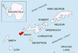
Bizone Rock is the rock off Snow Island in the South Shetland Islands, Antarctica extending 120 m in southeast-northwest direction and 100 m wide. It is the largest and southeasternmost in a group of several rocks extending 1.84 km in southeast-northwest direction and 1 km in a southwest-northeast direction.

Suhache Rock is the rock off the northwest coast of Robert Island in the South Shetland Islands, Antarctica extending 270 m (890 ft) in east-northeast to west-southwest direction and 50 m (160 ft) wide. The area was visited by early 19th century sealers.
Patresh Rock is a rock in Clothier Harbour on the northwest coast of Robert Island in the South Shetland Islands, extending 270 m in southeast-northwest direction with a width of 40 m. The area was visited by early 19th century sealers.
Leeve Island is the low ice-free island in the Onogur group off the northwest coast of Robert Island in the South Shetland Islands, Antarctica extending 200 m in southeast-northwest direction and 80 m wide. It is separated from Redina Island by a 100 m wide passage.

Nikudin Rock is the high, round rock of diameter 180 m and split in northeast-southwest direction, lying off the north coast of Greenwich Island in the South Shetland Islands. The area was visited by early 19th century sealers.
Klimash Passage is the 1.9 km wide passage in the South Shetland Islands between Table Island and Bowler Rocks on the northwest and Morris Rock and Chaos Reef, Aitcho Islands to the SE. The area was visited by early 19th century sealers.

Cacho Island is the conspicuous 250 m long in east–west direction and 100 m wide rocky island separated by a 160 m wide passage from Aktinia Beach on the southwest coast of Snow Island in the South Shetland Islands. Surface area 1.63 ha. The area was visited by early 19th century sealers.
Habermehl Rock is the rock off the north coast of Livingston Island in the South Shetland Islands, Antarctica 37 m long in southeast–northwest direction and 18 m wide, with a surface area of 0.02 ha. The vicinity was visited by early 19th century sealers.
Ramsden Rock is the rock off the north coast of Livingston Island in the South Shetland Islands, Antarctica 127 m long in southeast–northwest direction and 100 m wide. It is split in several abutting parts with an aggregate surface area of 0.47 ha. The vicinity was visited by early 19th century sealers.
Simms Rock is the rock off the north coast of Livingston Island in the South Shetland Islands, Antarctica 134 m long in southeast–northwest direction and 65 m wide, with a surface area of 0.42 ha. The vicinity was visited by early 19th century sealers.
Orsini Rock is the rock off the north coast of Livingston Island in the South Shetland Islands, Antarctica 90 m long in west–east direction and 46 m wide, with a surface area of 0.42 ha. The vicinity was visited by early 19th century sealers.
Baktriana Reef is the 360 m long in east-west direction and 40 m wide flat and rocky low-tide elevation off the west coast of Snow Island in the South Shetland Islands, Antarctica. Its surface area is 0.33 ha. The vicinity was visited by early 19th century sealers.
Borda Rock is the rock off the NW coast of Smith Island in the South Shetland Islands, Antarctica 270 m long in southwest-northeast direction and 90 m wide. Its surface area is 1.46 ha. The vicinity was visited by early 19th century sealers.


