
The Fildes Peninsula is a 7 km (4.3 mi) long peninsula that forms the south-western end of King George Island in the South Shetland Islands of Antarctica. It was named from association with nearby Fildes Strait by the UK Antarctic Place-Names Committee in 1960; the strait was likely named for Robert Fildes, a British sealer of the 1800s.
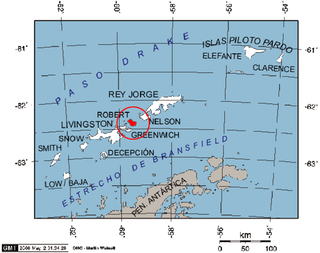
Robert Island or Mitchells Island or Polotsk Island or Roberts Island is an island 11 miles (18 km) long and 8 miles (13 km) wide, situated between Nelson Island and Greenwich Island in the South Shetland Islands, Antarctica. Robert Island is located at 62°24′S59°30′W. Surface area 132 km2 (51 sq mi). The name "Robert Island" dates back to around 1821 and is now established in international usage.

McFarlane Strait is a strait lying between Greenwich Island and Livingston Island, in the South Shetland Islands off Antarctica. It is 24 kilometres (13 nmi) long and 3 kilometres (1.6 nmi) wide. The name appears on an 1822 chart by Captain George Powell, a British sealer, and is now well established in international usage.

Morton Strait is the 9 km (4.9 nmi)-long and 6.2 km (3.3 nmi)-wide strait between Snow Island on the southwest and Rugged Island and Livingston Island on the northeast, in the South Shetland Islands, Antarctica. The Aim Rocks and Long Rock lie in the strait.

Hell Gates is a narrow boat passage between the Vardim Rocks and Devils Point on Byers Peninsula, connecting Raskuporis Cove and Osogovo Bay at the southwest end of Livingston Island in the South Shetland Islands, Antarctica. The name dates back to about 1821 and was applied by early sealers in the area because many lives and ships were lost here.
South Beaches are the beaches extending along the south side of Byers Peninsula, Livingston Island in the South Shetland Islands, Antarctica between Devils Point to the west and Rish Point to the east. The beaches were visited by 19th century sealers.
Bothy Bay is a small bay on the northwest side of Fildes Peninsula, King George Island. The entrance is 0.7 nautical miles (1.3 km) southeast of Square End Island and the bay is backed by a wide beach, with low cliffs on the northeast and southwest sides. The name, applied by the UK Antarctic Place-Names Committee in 1977, is suggested by a crude stone hut ("bothy"), evidently built by nineteenth-century sealers, on the shore of the bay.

Weeks Stack is a sea stack lying off the north tip of Nelson Island in the northern approach to Fildes Strait, in the South Shetland Islands. Situated 635 m north-northeast of Cariz (Agrelo) Point. Named by the United Kingdom Antarctic Place-Names Committee (UK-APC) in 1961 for Captain Weeks, Master of the British sealing vessel Horatio from London, who visited the South Shetland Islands in 1820–21.
Demay Point is a headland which forms the west side of the entrance to Admiralty Bay, King George Island, in the South Shetland Islands. This point was known to sealers as early as 1822. It was named almost 100 years later by the French Antarctic Expedition, 1908–10, under Jean-Baptiste Charcot. It has a Polish refuge, but it is unclear whether the refuge is being used at all
Suffield Point is the south-west entrance point of Norma Cove, Fildes Peninsula, on King George Island in the South Shetland Islands of Antarctica. It was charted in the course of the Discovery Investigations, 1933–35, and named after boatswain William E. Suffield. The site is part of the Fildes Peninsula Antarctic Specially Protected Area, designated as such because of its paleontological values.
Eddy Point is a small point located on the south side of Fildes Peninsula, 0.5 nautical miles (1 km) west of Halfthree Point on King George Island, in the South Shetland Islands. It was charted and named by Discovery Investigations personnel on the Discovery II in 1935. The feature is used as a reference point for locating the rocks which lie along the route of boats passing through Fildes Strait.

Emm Rock is a conspicuous rock 30 metres (100 ft) high, lying 0.5 nautical miles (1 km) off the south coast of King George Island at the east side of the entrance to Potter Cove, in the South Shetland Islands. This rock, presumably known to early sealers in the area, was sketched by the French Antarctic Expedition, 1908–10, under Jean-Baptiste Charcot, and charted by Discovery Investigations personnel on the Discovery II in 1935. The name derives from the shape of the rock, which resembles the letter M.

Parry Patch is a shoal lying in Nelson Strait 3 nautical miles (6 km) northwest of Harmony Point, Nelson Island, in the South Shetland Islands. The name Parry's Straits or Perry's Straits was applied to Nelson Strait by the British sealer Richard Sherratt in 1820–21, but the name did not become established. Parry Patch was applied by the United Kingdom Antarctic Place-Names Committee (UK-APC) in 1961 to preserve Sherratt's name in the area.
Fildes Point is a point which forms the north side of Neptunes Bellows, the entrance to Port Foster, Deception Island, in the South Shetland Islands of Antarctica. Deception Island was known to sealers in the area as early as 1821; the point was later named for Robert Fildes, a British sealer in these waters at that early time.

Fourcade Glacier is a glacier at the head of Potter Cove, Maxwell Bay, on King George Island in the South Shetland Islands. It was named by the Polish Antarctic Expedition, 1980, after Nestor H. Fourcade of the Instituto Antartico Argentino, who made detailed geological investigations of Potter Cove and Fildes Peninsula in several seasons, 1957–58 to 1960–61.

Half Moon Beach is a small crescent-shaped beach lying 1 nautical mile (2 km) south-east of Scarborough Castle on the north coast of Livingston Island, in the South Shetland Islands of Antarctica. The beach lieas at the western extremity of Porlier Bay in the north of Ioannes Paulus II Peninsula.
Scarborough Castle is a crag rising to about 30 m near the northeast Entrance point to Shirreff Cove, Livingston Island, in the South Shetland Islands. Roughly charted and named by British sealer Robert Fildes in 1821.
Rip Point is a point on Nelson Island forming the south side of the east entrance to Fildes Strait, in the South Shetland Islands. The name appears on a British Admiralty chart showing the results of a survey by DI personnel on the Discovery II in 1935.

Rugged Rocks is a small group of rocks at the west side of the south entrance to McFarlane Strait, lying just north of Renier Point, Burgas Peninsula on Livingston Island, in the South Shetland Islands. These rocks were known to early sealers in the area and appear on Powell's map of 1822. They were recharted in 1935 by DI personnel on the Discovery II and given this descriptive name.
Maxwell Bay, also called Fildes Bay and Guardia Nacional Bay is a bay 19 km (12 mi) long, lying between King George Island and Nelson Island, in the South Shetland Islands of Antarctica. The main entrance to the bay is at the south-east side and is wide open; Fildes Strait on the north-west side is encumbered by rocks and is only navigable by boats. The name "Maxwells Straits" was given to this bay and to Fildes Strait by British sealing captain James Weddell in 1822–24, for Lieutenant Francis Maxwell who had served with Weddell in 1813–14. The name was altered and limited to the feature here described by the UK Antarctic Place-Names Committee in 1960.

