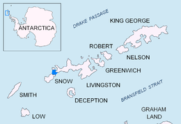
Greenwich Island is an island 24 km (15 mi) long and from 0.80 to 9.66 km wide, lying between Robert Island and Livingston Island in the South Shetland Islands, Antarctica.The island's surface area is 142.7 square kilometres (55.1 sq mi). The name Greenwich Island dates back to at least 1821 and is now established in international usage.

Boyana Glacier in Levski Ridge, Tangra Mountains on Livingston Island, South Shetland Islands in Antarctica is situated southeast of Macy Glacier and west-southwest of Srebarna Glacier. It is bounded by Vazov Rock on the west, St. Naum Peak, Starosel Gate, Silistra Knoll and Kotel Gap on the north, and Christoff Cliff on the east. The glacier extends 3 km in east-west direction and 1.6 km in north-south direction, and flows southeastward into the Bransfield Strait between Vazov Point and Aytos Point.

Magura Glacier on the southeast side of Tangra Mountains on Livingston Island in the South Shetland Islands, Antarctica is located to the north of M'Kean Point, northeast of Srebarna Glacier, south of Iskar Glacier and southwest of Dobrudzha Glacier. It is bounded by Great Needle Peak to the west, Vitosha Saddle, Vihren Peak and Helmet Peak to the northwest, Plovdiv Peak and Shishman Peak to the north, and Devin Saddle and Kuber Peak to the northeast. The glacier extends 3.5 km in southwest-northeast direction and 1.9 km in northwest-southeast direction, and flows southeastward into Bransfield Strait.

Prespa Glacier on Rozhen Peninsula, Livingston Island in the South Shetland Islands, Antarctica is situated east-northeast of Tarnovo Ice Piedmont, east of the head of Charity Glacier, southeast of Ruen Icefall and southwest of Macy Glacier. It is bounded to the east by Needle Peak and Ludogorie Peak, to the northwest by St. Cyril Peak and St. Methodius Peak, and to the southwest by Shumen Peak and Yambol Peak, and flows southeastward into Bransfield Strait between Gela Point and Samuel Point. The feature extends 3.5 km in east-west direction and 2.5 km in north-south direction. The glacier is named after Prespa Peak in the Rhodope Mountains, Bulgaria.

Spanish Point is located on Bulgarian Beach on Hurd Peninsula, eastern Livingston Island in the South Shetland Islands, Antarctica formed by an offshoot of Spanish Knoll.

Varna Peninsula is a roughly rectangular predominantly ice-covered peninsula forming the northeast extremity of Livingston Island in the South Shetland Islands, Antarctica. It is bounded by Hero Bay to the northwest, by Moon Bay to the southeast, and by McFarlane Strait to the northeast.

Vergilov Rocks are a group of rocks off Bulgarian Beach on Hurd Peninsula in eastern Livingston Island in the South Shetland Islands, Antarctica, consisting of one main rock and two adjacent smaller ones submerging at high water.

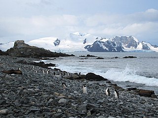
The Aitcho Islands are a group of minor islands on the west side of the north entrance to English Strait separating Greenwich Island and Robert Island in the South Shetland Islands, Antarctica, which are situated between Dee Island to the south and Table Island to the north. The group is separated from Dee Island and Sierra Island to the southwest by Villalón Passage. The area was visited by early 19th century sealers operating from nearby Clothier Harbour. During the austral summer the islands are often visited by Antarctic cruise ships with tourists who land to watch wildlife.
Inepta Cove is a cove on the northwest side of Rozhen Peninsula, part of False Bay, Livingston Island in the South Shetland Islands, Antarctica. The feature's configuration has changed markedly, and it has eventually disappeared as a result of the retreat of Huntress Glacier during the last decade of the 20th century and the first decade of the 21st century.

Avren Rocks are three adjacent rocks situated in the interior of Micalvi Cove in the south extremity of Robert Island, South Shetland Islands. The group extends 260 m (280 yd) in north–south direction and is 150 m (160 yd) wide. The rocks were first mapped in 2008 by a Bulgarian team. They are named after two settlements in Varna and Kardzhali provinces situated in northeastern and southeastern Bulgaria respectively.
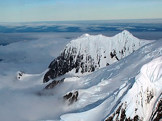
Helmet Peak is a conspicuous peak rising to 1,254 metres (4,114 ft) in Levski Ridge, Tangra Mountains on Livingston Island in the South Shetland Islands, Antarctica just southward of the mouth of Huron Glacier. It is bounded by Devnya Valley to the west, Iskar Glacier to the northeast, and Magura Glacier to the southeast, and has precipitous west and east slopes. It was named by Discovery Investigations personnel during the period 1926–32.

McFarlane Strait is a strait lying between Greenwich Island and Livingston Island, in the South Shetland Islands off Antarctica. It is 24 kilometres (13 nmi) long and 3 kilometres (1.6 nmi) wide. The name appears on an 1822 chart by Captain George Powell, a British sealer, and is now well established in international usage.

Morton Strait is the 9 km (4.9 nmi)-long and 6.2 km (3.3 nmi)-wide strait between Snow Island on the southwest and Rugged Island and Livingston Island on the northeast, in the South Shetland Islands, Antarctica. The Aim Rocks and Long Rock lie in the strait.
Williams Point is the point forming both the north extremity of Varna Peninsula and the northeast tip of Livingston Island in the South Shetland Islands, Antarctica. Separated from Zed Islands to the north by Iglika Passage.

San Telmo Island is an island forming the west side of Shirreff Cove on the north-west coast of Ioannes Paulus II Peninsula, Livingston Island in the South Shetland Islands of Antarctica. It has a surface area of 22 hectares.

Hell Gates is a narrow boat passage between the Vardim Rocks and Devils Point on Byers Peninsula, connecting Raskuporis Cove and Osogovo Bay at the southwest end of Livingston Island in the South Shetland Islands, Antarctica. The name dates back to about 1821 and was applied by early sealers in the area because many lives and ships were lost here.

Neck or Nothing Passage is a narrow passage leading from Blythe Bay between Iratais Point in the south end of Desolation Island and Miladinovi Islets, in the South Shetland Islands. The name was applied prior to 1830, probably by whalers who frequented Blythe Bay and who at times ran their vessels to sea via this passage to escape severe easterly gales.
Charity Glacier is a glacier on Rozhen Peninsula, Livingston Island in the South Shetland Islands, Antarctica draining the southwest slopes of St. Methodius Peak in Tangra Mountains, and flowing west-southwestwards into False Bay north of Barnard Point, between Zagore Beach and Arkutino Beach.
Sally Rocks is a small group of rocks trending southwestwards in South Bay just off the west coast of Hurd Peninsula, Livingston Island in the South Shetland Islands, Antarctica.
Long Rock is a large rock extending 720 m (787 yd) in east–west direction, 180 m (197 yd) wide and rising to 13 m (42.7 ft) in the northeast of Morton Strait in the South Shetland Islands, Antarctica. The area was visited by early 19th century sealers operating on Byers Peninsula.


