Wordie Seamount is a seamount located in Bransfield Strait, Antarctica. The feature is named after James Wordie, geologist on Ernest Shackleton's 1914 expedition to Antarctica. [1] [2]
Wordie Seamount is a seamount located in Bransfield Strait, Antarctica. The feature is named after James Wordie, geologist on Ernest Shackleton's 1914 expedition to Antarctica. [1] [2]
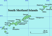
Wordie Seamount is located at 61°48′S55°27′W / 61.800°S 55.450°W , which is 37 km (23 mi) south of Gibbs Island in the South Shetland Islands.
Rowett Island is a rocky island 0.5 miles (0.8 km) long, lying immediately off Cape Lookout, Elephant Island, in the South Shetland Islands. Rowett Island is located at 61°17′S55°13′W. Rowett Island was known to both American and British sealers as early as 1822. Rowett Island was named by members of a British expedition (1921-1922) under Ernest Shackleton for John Quiller Rowett, chief patron of the expedition.

Endurance Glacier is a broad glacier north of Mount Elder, draining south-east to the south coast of Elephant Island in the South Shetland Islands of Antarctica, and is the main discharge glacier on the island. It was named by the UK Antarctic Place-Names Committee after HMS Endurance, which anchored off the glacier on several occasions in support of the Joint Services Expedition to Elephant Island, 1970–71.
Aspland Island is a small island 7.4 km (4 nmi) west of Gibbs Island in the South Shetland Islands of Antarctica. The name dates back to at least 1821.

Pasarel Island is an ice-free island in the Aitcho group on the west side of English Strait in the South Shetland Islands, Antarctica. The island is situated 900 m (980 yd) northwest of Barrientos Island, 1.35 km (0.84 mi) northeast of Sierra Island and 650 m (710 yd) southeast of Emeline Island. Extending 450 by 260 m. The area was visited by early 19th century sealers.
Bilyana Island is an ice-free island in the Aitcho group on the west side of English Strait in the South Shetland Islands, Antarctica. Extending 450 by 290 m, surface area 10 hectares. The area was visited by early 19th century sealers.

Chiprovtsi Point is a point projecting 400 m (440 yd) northwestwards from the north coast of Rugged Island off the west coast of Byers Peninsula of Livingston Island in the South Shetland Islands, Antarctica, and forming the east side of the entrance to Nishava Cove. It is extended further 400 m (440 yd) northwestwards by the group of Chiprovtsi Islets, which are centred at 62°36′52″S61°16′09″W and named in association with the point.

Tsamblak Hill is a rocky hill trending 900 m in north–south direction, 450 m wide and rising to 113 m in eastern Byers Peninsula on Livingston Island in the South Shetland Islands, Antarctica. It surmounts Bedek Stream on the east, Feya Tarn on the south-southwest and Eridanus Stream on the west.
Vardim Rocks are a group of rocks situated on the south side of Hell Gates, facing Devils Point in the southwest extremity of Byers Peninsula on Livingston Island in the South Shetland Islands, Antarctica. Extending 1.3 km (0.81 mi) in east-west direction. The two principal islets in the group, Demon and Sprite, are extending 420 by 400 m and 270 by 150 m respectively, with surface area of the former 9 hectares. The area was visited by early 19th century sealers.

Lesidren Island is the second largest and southernmost island in the Zed group off the north coast of Varna Peninsula, Livingston Island in the South Shetland Islands, Antarctica. The island is ice-free, extending 800 by 600 m with surface area 33 hectares. Separated from the neighbouring Phanagoria Island and Koshava Island by channels 130 and 140 m wide respectively. The area was visited by early 19th century sealers.
Window Island is a small ice-free island off the north coast of Ray Promontory in the northwest of Byers Peninsula, Livingston Island in the South Shetland Islands, Antarctica. The island has a surface area of 23 hectares and rises to 72 m (236 ft). It was known to the early 19th century sealers operating on Byers Peninsula.

Frederick Rocks is a group of rocks lying in Barclay Bay on the north side of Livingston Island in the South Shetland Islands, Antarctica. The area was visited by early 19th century sealers operating on nearby Byers Peninsula.
Richards Cove is the 450 m wide cove indenting for 550 m the north coast of Ray Promontory, Byers Peninsula, Livingston Island in the South Shetland Islands, Antarctica, entered east of Aglen Point and west of Voyteh Point. The area was visited by early 19th century sealers.

Stinker Point is a headland 7 km (4.3 mi) south of Table Bay and 2.2 km (1.4 mi) northwest of Piperkov Point on the west coast of Elephant Island, in the South Shetland Islands of Antarctica. It was mapped by the UK Joint Services Expedition to Elephant Island, 1970–71, and named after the southern giant petrels which breed there, "stinker" being an old sailors' name for the bird.

Point Wordie is a headland on the western coast of Elephant Island, in the South Shetland Islands of Antarctica. The site is named after James Wordie, a Scottish geologist who participated in Ernest Shackleton’s Imperial Trans-Antarctic Expedition, 1914–1917.

Korsis Island is the rocky island lying 150 m off the northwest coast of Snow Island in the South Shetland Islands, Antarctica. It extends 300 m in southeast-northwest direction and 180 m wide. The feature is named after the Bulgarian military commander Korsis, 9th century.
Gergini Reef is the triangular flat and rocky low-tide elevation off the northwest coast of Snow Island in the South Shetland Islands, Antarctica. It extends 400 m in east–west direction and is 210 m wide. The feature is named after the settlement of Gergini in Northern Bulgaria.

Bekas Rock is the 140 m long in southwest-northeast direction and 60 m wide rock lying west of Rugged Island on the west side of Livingston Island in the South Shetland Islands, Antarctica. The area was visited by early 19th century sealers.

Biruni Island is the rocky island off the north coast of Elephant Island in the South Shetland Islands, Antarctica 450 m long in southwest–northeast direction and 150 m wide, with a surface area of 3.59 ha. It is separated from Elephant Island by a passage narrowing to 70 m at points. The island was formed as a result of the retreat of Elephant Island's ice cap at the turn of the 21st century.
Brahe Rock is the rock off the north coast of Livingston Island in the South Shetland Islands, Antarctica 85 m long in west–east direction and 50 m wide, and split in three. Its surface area is 0.14 ha. The vicinity was visited by early 19th century sealers.
Wordie may refer to:
{Reflist}}
| | This South Shetland Islands location article is a stub. You can help Wikipedia by expanding it. |
| | This article about a specific oceanic location or ocean current is a stub. You can help Wikipedia by expanding it. |