True South | |
Use | National Antarctic programs, nonprofits, expedition teams, and individuals from countries across the globe have formally adopted the flag |
---|---|
Proportion | 2:3 |
Adopted | the consultative members of the Antarctic Treaty System have officially adopted it as emblem only in 2002 |
Design | Horizontal stripes of navy and white represent the long days and nights at Antarctica's extreme latitude |
Designed by | Evan Townsend |
As a condominium with no single governing body, the continent of Antarctica does not have an official flag of its own. However, several designs have been created for the purpose of representing the continent.
This should be distinguished from flags flown in Antarctica in general, which includes those used by national missions and outposts in Antarctica.
Since the 1970s, there have been many designs proposed as a flag for Antarctica. [1]
In 1929, members of the British Australian and New Zealand Antarctic Research Expedition on RRS Discovery used white cotton sheeting to improvise a courtesy ensign (a flag used as a token of respect by vessels while in foreign waters) for a continent without a flag of its own. It is now in the National Maritime Museum in London. The white flag was used to represent Antarctica on at least two occasions on the voyage to Antarctica. On 1 August 1929, The Times noted that "the ship was flying the Union Jack at her forepeak, the white Antarctic flag at the foremast, and the Australian flag at the stern." [2] [3]
Vexillologist Whitney Smith presented an orange flag with a white emblem in the hoist at the 1978 annual meeting of the North American Vexillological Association (NAVA). The letter A stands for Antarctica, the semi-sphere represents the area below the Antarctic Circle, and the hands represent human protection of the environment. For high visibility, he chose international orange, a color commonly used in the aerospace industry to set objects apart from their surroundings. [1] The bright orange color was also chosen due to its rarity among national flags, as no nation with an active research base on the continent uses the color orange in their flag. The design elements are positioned on the hoist side of the flag so that it would remain visible even if the flag were damaged by the harsh Antarctic winds. [4]
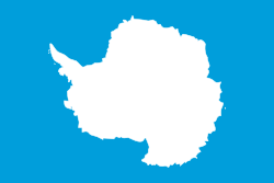
Graham Bartram, the chief vexillologist of British organization Flag Institute, designed another proposal in 1996 for a 3D Atlas program developed by The MultiMedia Corporation and published by Electronic Arts. [5] Using the flag of the United Nations as his model, he chose a plain white map of the continent on a blue background to symbolize neutrality. The flag was inspired by the emblem of the Antarctic Treaty System. [6]
Vexillologist Ted Kaye had Bartram's design printed and took them with him on an Antarctic cruise. At Kaye's request, it flew at the Brazilian base Comandante Ferraz and the British museum at Port Lockroy. [1] Since 2015, Bartram's design has been used on most supported platforms as the "Flag of Antarctica" emoji implemented using the regional indicator symbol sequence AQ. [7]
In a 2024 update to his design, Bartram introduced modifications to the flag which were aimed at raising awareness about the environmental challenges facing the continent, specifically focusing on the issue of microplastic pollution. This initiative seeks to highlight the presence of microplastics in Antarctica, drawing global attention to the impact on wildlife and ecosystems and advocating for international efforts to tackle this pressing issue. [8]
The True South proposal was designed by Evan Townsend in 2018. [9] [10] The flag has the following meaning:
Horizontal stripes of navy and white represent the long days and nights at Antarctica's extreme latitude. In the center, a lone white peak erupts from a field of snow and ice, echoing those of the bergs, mountains, and pressure ridges that define the Antarctic horizon. The long shadow it casts forms the unmistakable shape of a compass arrow pointed south, an homage to the continent's legacy of exploration. Together, the two center shapes create a diamond, symbolizing the hope that Antarctica will continue to be a center of peace, discovery, and cooperation for generations to come. [11]
The flag is named after geographic South, or "true South", which differs from magnetic south. [12]
The flag has quickly gained popularity since its introduction. [13] It has been adopted by a few National Antarctic Programs, [14] [15] Antarctic nonprofits, and expedition teams; flown at several research stations across Antarctica; [16] and was used in the 2022 marker for the geographic South Pole. [17]
The emblem of the Antarctic Treaty System is occasionally used, both for its use by its members since the first consultative meeting in 1961 [18] [19] and for having inspired other similar flags. [6] While the origin of this design can be traced to the first redaction of the treaty in 1959, [20] the consultative members of the Antarctic Treaty System have officially adopted it as emblem only in 2002. [21]
The emblem is used in the form of a flag, [22] [23] [24] among other forms, along with being used on all official documents, and officially this emblem represents the Antarctic Treaty System and not the continent itself. [22] A commemorative stamp was also issued by the US Post Office in 1971. [25]
The Antarctic Treaty and related agreements, collectively known as the Antarctic Treaty System (ATS), regulate international relations with respect to Antarctica, Earth's only continent without a native human population. It was the first arms control agreement established during the Cold War, designating the continent as a scientific preserve, establishing freedom of scientific investigation, and banning military activity; for the purposes of the treaty system, Antarctica is defined as all the land and ice shelves south of 60°S latitude. Since September 2004, the Antarctic Treaty Secretariat, which implements the treaty system, is headquartered in Buenos Aires, Argentina.
The flag of Europe or European flag consists of twelve golden stars forming a circle on a blue field. It is the official flag of the European Union. It was designed and adopted in 1955 by the Council of Europe (CoE) as a symbol for the whole of Europe.
The Australian Antarctic Territory (AAT) is a part of East Antarctica claimed by Australia as an external territory. It is administered by the Australian Antarctic Division, an agency of the federal Department of Climate Change, Energy, the Environment and Water. The territory's history dates to a claim on Enderby Land made by the United Kingdom in 1841, which was subsequently expanded and eventually transferred to Australia in 1933. It is the largest Antarctica claimed by any by area. Australia is an original signatory to the Antarctic Treaty of 1961. Under section 4, all territorial claims are held in abeyance. Only four other countries accept Australia's claim to sovereignty, being New Zealand, the United Kingdom, France and Norway, all of whom have territorial claims in Antarctica and mutually accept each other’s claims.
The flag of New Zealand, also known as the New Zealand Ensign, is based on the British maritime Blue Ensign – a blue field with the Union Jack in the canton or upper hoist corner – augmented or defaced with four red stars centred within four white stars, representing the Southern Cross constellation.
The flag of Ontario is a defaced Red Ensign, with the Royal Union Flag in the canton and the Ontario shield of arms in the fly. The flag of Ontario was derived from the Canadian Red Ensign, which was used as a civil ensign and as a de facto flag of Canada from the late 19th century to 1965. It was adopted in a period when many Canadian provinces adopted their own flags. May 21 is Ontario Flag Day.
The Indian Antarctic Programme is a multi-disciplinary, multi-institutional programme under the control of the National Centre for Polar and Ocean Research, Ministry of Earth Sciences, Government of India. It was initiated in 1981 with the first Indian expedition to Antarctica. The programme gained global acceptance with India's signing of the Antarctic Treaty and subsequent construction of the Dakshin Gangotri Antarctic research base in 1983, superseded by the Maitri base from 1989. The newest base commissioned in 2012 is Bharati, constructed out of 134 shipping containers. Under the programme, atmospheric, biological, earth, chemical, and medical sciences are studied by India, which has carried out 40 scientific expeditions to the Antarctic.
The Scientific Committee on Antarctic Research (SCAR) is an interdisciplinary body of the International Science Council (ISC). SCAR coordinates international scientific research efforts in Antarctica, including the Southern Ocean.
Stonington Island is a rocky island lying 1.8 km (1.1 mi) northeast of Neny Island in the eastern part of Marguerite Bay off the west coast of Graham Land, Antarctica. It is 0.75 km (0.47 mi) long from north-west to south-east and 0.37 km (0.23 mi) wide, yielding an area of 20 ha. It was formerly connected by a drifted snow slope to Northeast Glacier on the mainland. Highest elevation is Anemometer Hill which rises to 25 m (82 ft).
Colonization of Antarctica is the establishing and maintaining of control over Antarctic land for exploitation and possibly settlement.
Captain Arturo Prat Base is a Chilean Antarctic research station located at Iquique Cove, Greenwich Island in the South Shetland Islands, Antarctica.
Religion in Antarctica is largely dominated by Christianity, with churches being the only religious buildings on the continent. Although used regularly for Christian worship, the Chapel of the Snows has also been used for Buddhist and Baháʼí Faith ceremonies. Some of the early religious buildings are now protected as important historical monuments.
Seven sovereign states – Argentina, Australia, Chile, France, New Zealand, Norway, and the United Kingdom – have made eight territorial claims in Antarctica. These countries have tended to place their Antarctic scientific observation and study facilities within their respective claimed territories; however, a number of such facilities are located outside of the area claimed by their respective countries of operation, and countries without claims such as China, India, Italy, Japan, Pakistan, Russia, South Africa (SANAE), Poland, and the United States have constructed research facilities within the areas claimed by other countries. There are overlaps among the territories claimed by Argentina, Chile, and the United Kingdom.
The Flag of Sussex is the flag of the traditional and historic county of Sussex. The flag was registered by the Flag Institute on Friday 20 May 2011 as a 'traditional' county flag as a result of a campaign started in August 2010, by Sussex resident Brady Ells, with support from his father, David. The Flag was certified by Chief Vexillologist, Graham Bartram. It was first flown officially on Saturday 28 May 2011 at Lewes Castle. and was flown from the Department of Communities and Local Government at Eland House, London on Sussex Day, 16 June 2011.
The South Pole, also known as the Geographic South Pole or Terrestrial South Pole, is the point in the Southern Hemisphere where the Earth's axis of rotation meets its surface. It is called the True South Pole to distinguish from the Magnetic South Pole.
Damoy Point is a headland 900 metres (980 yd) west-northwest of Flag Point, the northern entrance point to the harbour of Port Lockroy, on the western side of Wiencke Island in the Palmer Archipelago of Antarctica. It was discovered and named by the French Antarctic Expedition, 1903–05, under Jean-Baptiste Charcot.
Council of Managers of National Antarctic Programs (COMNAP) is an international association that develops and promotes best practice in managing the support of scientific research in Antarctica. Members are composed of national research programs who respective governments are signatories to the Antarctic Treaty committing the continent as a natural reserve.
The Antarctic Treaty issue is a postage stamp that was issued by the United States Post Office Department on June 23, 1971. Designed by Howard Koslow, it commemorates the tenth anniversary of the Antarctic Treaty, and is notable as Koslow's first postage stamp design.
Antarctica Day is an international holiday recognizing the anniversary of the signing of the Antarctic Treaty in 1959. It is celebrated on December 1 each year. Along with Midwinter Day, it is one of Antarctica's two principal holidays.
Events in the year 2002 in the Antarctica.
...One flag was designed by Graham Bartram and is very similar to the flag of the Antarctic Treaty, and the other is by Whitney Smith... Neither of these flags has ever been flown on the territories governed by the treaty.
The representatives recommend their governments:...that the most prominent feature of the stamp should be the Atlantic Treaty emblem representing a map of Antarctica, which appears on the official documents of consultative meetings;