List of flags of Equatorial Guinea

Last updated

This is a list of flags used in Equatorial Guinea in Africa. For more information about the national flag, see flag of Equatorial Guinea.

Contents

National flag

FlagDateUseDescription
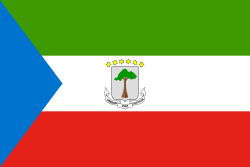
Flag of Equatorial Guinea.svg 1979–PresentState Flag of Equatorial GuineaA horizontal tricolor of green, white and red with a blue isosceles triangle based on the hoist side and the National Coat of arms of Equatorial Guinea centered in the white band. [1]

Ethnic group flags

FlagDateUseDescription
Bubi nationalist flag.svg Bubi Nationalist Flag [2] a horizontal tricolour of blue, white and green with a black 4 pointed star centered in the white band.
Bubi tribal flag.svg Bubi Tribal Flag [3] 9 horizontal stripes alternating red and green in the canton,a white triangle with 2 flutes on a blue field.

Municipality flags

FlagDateUseDescription
Bandera de la Ciudad Malabo.png Flag of Malabo a cyan field with an emblem in the center.

Historical flags

FlagDateUseDescription
Flag of Equatorial Guinea (1973-1979).svg 1973–19793rd State Flag of Equatorial GuineaA horizontal tricolor of green, white and red with a blue isosceles triangle based on the hoist side and the emblem of Francisco Nguema centered in the white band. [4]
Flag of Equatorial Guinea.svg 1969-19732nd State Flag of Equatorial GuineaA horizontal tricolor of green, white and red with a blue isosceles triangle based on the hoist side and the National Coat of arms of Equatorial Guinea centered in the white band.
Flag of Equatorial Guinea (without coat of arms).svg 1968–19691st State Flag of Equatorial GuineaA horizontal tricolor of green, white and red with a blue isosceles triangle based on the hoist side. [5]
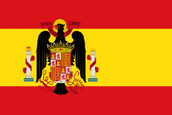
Flag of Spain (1945-1977).svg 1945–1968Flag of Francoist Spainsimilar to the previous flag, but with a bigger eagle.
Flag of Spain (1938-1945).svg 1938–1945Flag of Francoist Spainthree horizontal stripes: red, yellow and red, the yellow strip being twice as wide as each red stripe with the francoist eagle coat of arms off-centred toward the hoist.
Bandera del bando nacional 1936-1938.svg 1936–1938Flag of Francoist Spain three horizontal stripes: red, yellow and red, the yellow strip being twice as wide as each red stripe with the coat of arms centered in the yellow band.
Flag of Spain (1931-1939).svg 1931–1936Flag of the Second Spanish Republic a horizontal tricolour of red, yellow and purple with the coat of arms centered in the yellow band.
Flag of the First Spanish Republic.svg 1873–1874Flag of the First Spanish Republic three horizontal stripes: red, yellow and red, the yellow strip being twice as wide as each red stripe with the coat of arms off-centred toward the hoist.
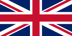
Flag of the United Kingdom.svg 1827–1858Flag of the United Kingdom (During The British Rule in Bioko)A superimposition of the flags of England and Scotland with the Saint Patrick's Saltire (representing Ireland).
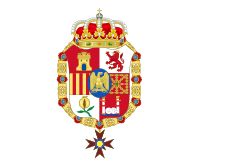
Bandera de Espana 1808-1813.svg 1808–1813Flag of Napolenonic Spain a white field with the royal coat of arms off-centred toward the hoist.
Flag of France (1794-1815, 1830-1974, 2020-present).svg 1808–1813Flag of The First French Empire a vertical tricolour of Blue, White and Red.
Flag of Spain (1785-1873, 1875-1931).svg 1785–1873
1874–1931
Flag of The Kingdom of Spainthree horizontal stripes: red, yellow and red, the yellow strip being twice as wide as each red stripe with the royal coat of arms off-centred toward the hoist.
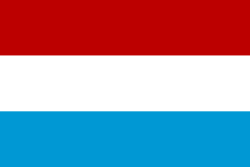
Statenvlag.svg 1662–1664 States Flag a horizontal tricolour of Red, White and Light Blue.
Prinsenvlag.svg 1641–1649
1662–1664
The Prince's Flag (during the Dutch occupations of Annobón)a horizontal tricolour of Orange, White and Blue.
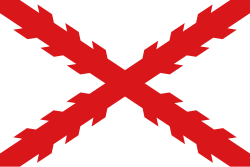
Flag of Cross of Burgundy.svg 1580–1785Flag of The Kingdom of Spain A red saltire resembling two crossed, roughly-pruned (knotted) branches, on a white field.
Flag of Portugal (1578).svg 1578–1580Flag of The Kingdom of Portugala white field with the coat of arms in the center.
Flag of Portugal (1521).svg 1521–1578Flag of The Kingdom of Portugala white field with the coat of arms in the center.
Flag of Portugal (1495).svg 1495–1521Flag of The Kingdom of Portugala white field with the coat of arms in the center.
PortugueseFlag1485.svg 1485–1495Flag of The Kingdom of PortugalFive blue escutcheons each charged with 5 bezants on a white field. Border: red with 7 yellow castles.
PortugueseFlag1385.svg 1472–1485Flag of The Kingdom of Portugal Five blue escutcheons each charged with an undetermined number of bezants on a white field. Border: red with yellow castles and a green cross of the Order of Aviz.

See also

Related Research Articles

<span class="mw-page-title-main">Equatorial Guinea</span> Country in Central Africa

Equatorial Guinea, officially the Republic of Equatorial Guinea, is a country on the west coast of Central Africa, with an area of 28,000 square kilometres (11,000 sq mi). Formerly the colony of Spanish Guinea, its post-independence name refers to its location near both the Equator and in the African region of Guinea. As of 2024, the country had a population of 1,795,834, over 85% of whom are members of the Fang people, the country's dominant ethnic group. The Bubi people, indigenous to Bioko, are the second largest group at approximately 6.5% of the population.

<span class="mw-page-title-main">History of Equatorial Guinea</span>

The History of Equatorial Guinea is marked by centuries of colonial domination by the Portuguese, British and Spanish colonial empires, and by the local kingdoms.

<span class="mw-page-title-main">Demographics of Equatorial Guinea</span>

Demographic features of the population of Equatorial Guinea include population density, ethnicity, education level, health of the populace, economic status, religious affiliations and other aspects of the population.

<span class="mw-page-title-main">Politics of Equatorial Guinea</span>

The politics of Equatorial Guinea take place in a framework of a presidential republic, whereby the President is both the head of state and head of government. Executive power is exercised by the government. Legislative power is vested in both the government and the Chamber of People's Representatives

<span class="mw-page-title-main">Malabo</span> Capital of Equatorial Guinea

Malabo is the capital of Equatorial Guinea and the province of Bioko Norte. It is located on the north coast of the island of Bioko. In 2018, the city had a population of approximately 297,000 inhabitants.

<span class="mw-page-title-main">Culture of Equatorial Guinea</span>

While lying on the enriched continent of Africa, Equatorial Guinea has proved to be entrenched in ancient rituals and songs. This is especially true for the Fang, a people whose territories begin at the southern edge of Cameroon south of Kribi, Djoum, and Mvangan in the South Province and continue south across the border, including all of Río Muni in Equatorial Guinea, and from there south into Gabon and Congo. The capital island of Bioko has largely been influenced by Spanish customs and traditions during the colonial period, when education and health services were developed in the country.

<span class="mw-page-title-main">Music of Equatorial Guinea</span>

Equatorial Guinea's culture has been less documented than most African countries, and commercial recordings remain scarce.

<span class="mw-page-title-main">Flag of Equatorial Guinea</span> National flag

The flag of Equatorial Guinea was adopted on August 21, 1979. The six stars on the flag represent Equatorial Guinea's mainland and five islands. Under the rule of dictator Francisco Nguema the flag was modified and a different national emblem was used in it. After he was deposed the original flag was restored.

<span class="mw-page-title-main">Bubi people</span> Bantu ethnic group of Equatorial Guinea

The Bubi people are a Bantu ethnic group of Central Africa who are indigenous to Bioko Island, Equatorial Guinea. Once the majority group in the region, the population experienced a sharp decline due to war and disease during Portuguese expeditions. By the end of Spanish colonial rule in the mid 20th century, and after substantial intermarriage with newly introduced populations, such as Afro-Cubans, Krio people, Portuguese people and Spaniards, the Bubi people, again, experienced a great decline in number. Seventy-five percent perished due to tribal/clan rooted political genocide during a civil war that led to Spanish Guinea's independence from Spain. This, too, sparked mass exodus from their homeland with most of the exiles and refugees immigrating into Spain. The indigenous Bubi of Bioko Island have since co-existed with non-indigenous Krio Fernandinos; and members of the Fang ethnic group, who have immigrated in large numbers from Río Muni. Once numbering approximately 3 million, the Bubi currently number around 100,000 worldwide.

<span class="mw-page-title-main">Spanish Guinea</span> Former Spanish colony in West Africa

Spanish Guinea was a set of insular and continental territories controlled by Spain from 1778 in the Gulf of Guinea and on the Bight of Bonny, in Central Africa. It gained independence in 1968 as Equatorial Guinea.

<span class="mw-page-title-main">Movement for the Self-Determination of Bioko Island</span> Political organization in Equatorial Guinea

The Movement for the Self-Determination of Bioko Island is a proscribed political organization in Equatorial Guinea. It has its roots in the pre-independence Unión Bubi, which sought independence from the mainland half of Spanish Guinea. It is supported by the Bubi ethnic group, which dominates Bioko island.

<span class="mw-page-title-main">Bioko Norte</span> Province of Equatorial Guinea

Bioko Norte is the second-most populated of the eight provinces of Equatorial Guinea, after the Litoral province. Both the provincial capital, Rebola, and the national capital, Malabo are located here. Heavily forested with little urban development, the southern central part includes part of the Parque Nacional del Pico Basilé, a 330 square kilometres (130 sq mi) national park which was established in 2000.

<span class="mw-page-title-main">Cristino Seriche Bioko</span> Equatoguinean politician (1940–2024)

Cristino Seriche Bioko was an Equatoguinean soldier and politician who was the Prime Minister of Equatorial Guinea from 15 August 1982 to 4 March 1992. He previously served as Vice President under Teodoro Obiang Nguema Mbasogo for almost one year, from December 1981 to until the position was abolished in October 1982 according to the constitutional referendum, at which point he became president.

<span class="mw-page-title-main">Pico Basilé</span> Tallest mountain of Equatorial Guinea

Pico Basilé, located on the island of Bioko, is the tallest mountain of Equatorial Guinea. With an elevation of 9,878 ft, it is the summit of the largest and highest of three overlapping basaltic shield volcanoes which form the island. From the summit, Mt. Cameroon can be seen to the northeast. Pico Basilé lies close to the city of Malabo. The very top is used as a broadcast transmitting station for RTVGE and microwave relay station for various communication networks.

Bube, Bohobé or Bube–Benga is a Bantu language spoken by the Bubi, a Bantu people native to, and once the primary inhabitants of Bioko Island in Equatorial Guinea. The language was brought to Bioko from continental Africa more than three thousand years ago when the Bubi began settling on the island.

<span class="mw-page-title-main">Malabo Lopelo Melaka</span> Bubi king

Malabo Löpèlo Mëlaka or King Malabo I, born on the island of Fernando Po, was the son of former Bubi king Moka and served as king between 1904 until his death in 1937, during the Bahítáari Dynasty. One of his three sons, Francisco Malabo Beosá (1896–2001) was a successor to the royal throne and heir to the Bubi Kingdom.

Francisco Malabo Beosá or King Malabo II, was an African monarch, born on the island of Fernando Po in Spanish Guinea, was the son of former Bubi king Malabo Lopelo Melaka and the second last legitimate successor of the Bubi Kingdom.

<span class="mw-page-title-main">Justo Bolekia Boleká</span> Equatoguinean scholar (born 1954)

Justo Bolekia Boleká is an Equatorial Guinean scholar and writer of Bubi descent.

<span class="mw-page-title-main">Bioko</span> Northern island of Equatorial Guinea, Central Africa

Bioko is an island of Equatorial Guinea. It is located 32 km (20 mi) south of the coast of Cameroon, and 160 km (99 mi) northwest of the northernmost part of mainland Equatorial Guinea. Malabo, on the north coast of the island, is the capital city of Equatorial Guinea. Its population was 335,048 at the 2015 census and it covers an area of 2,017 km2 (779 sq mi). The island is part of the Cameroon line of volcanoes and is located off the Cameroon coast, in the Bight of Biafra portion of the Gulf of Guinea. Its geology is volcanic; its highest peak is Pico Basile at 3,012 m (9,882 ft).

References

  1. "National Flag of Equatorial Guinea". Worldflags. Retrieved 17 September 2014.
  2. "Bubi / Bioko Island (Equatorial Guinea)". www.crwflags.com. Retrieved 2022-03-24.
  3. "Bubi / Bioko Island (Equatorial Guinea)". www.crwflags.com. Retrieved 2022-03-24.
  4. Anjali Kamath. Flag Book. Popular Prakashan. p. 16. ISBN   978-81-7991-512-7.
  5. "Equatorial Guinea (1973–1979)". Crwflags.com. Retrieved 17 September 2014.