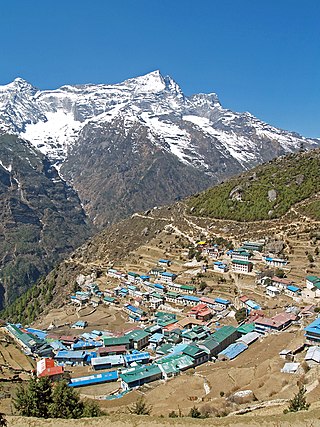
Kathmandu, officially the Kathmandu Metropolitan City, is the seat of federal government and the most populous city in Nepal. As of the 2021 Nepal census, there were 845,767 inhabitants living in 105,649 households and approximately 4 million people in its surrounding agglomeration. It is located in the Kathmandu Valley, a large valley surrounded by hills in central Nepal, at an altitude of 4,344 feet above sea level.

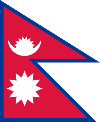
The national symbol of Nepal is the world's only non-rectangular symbol which is used as both the state and civil flag of a sovereign country. The symbol is a simplified combination of two single pennants, known as a double-pennon. Its crimson red is the symbol of bravery and it also represents the color of the rhododendron, Nepal's national flower, while the blue border is the color of peace. Until 1962, the symbol's emblems, both the sun and the crescent moon, had human faces, but they were removed to modernize the symbol.

Nepal, officially the Federal Democratic Republic of Nepal, is a landlocked country in South Asia. It is mainly situated in the Himalayas, but also includes parts of the Indo-Gangetic Plain. It borders the Tibet Autonomous Region of China to the north, and India to the south, east, and west, while it is narrowly separated from Bangladesh by the Siliguri Corridor, and from Bhutan by the Indian state of Sikkim. Nepal has a diverse geography, including fertile plains, subalpine forested hills, and eight of the world's ten tallest mountains, including Mount Everest, the highest point on Earth. Kathmandu is the nation's capital and the largest city. Nepal is a multi-ethnic, multi-lingual, multi-religious, and multi-cultural state, with Nepali as the official language.

Mahendra Bir Bikram Shah Dev was King of Nepal from 13 March 1955 until his death in 1972, which was due to a heart attack, as told in an interview by his personal physician Dr. Mrigendra Raj Pandey. Following the 1960 coup d'état, he established the party-less Panchayat system, which governed the country for 28 years until the introduction of multi-party democracy in 1990. During his reign, Nepal experienced a period of industrial, political and economic change which opened it to the rest of the world for the first time, after the 104-year-long reign of the Rana rulers, who kept the country under an isolationist policy, came to an end in 1951.

Pokhara is a metropolitan city located in central Nepal, which serves as the capital of Gandaki Province and is declared as the tourism capital of Nepal. It is the second most populous city of the nation after Kathmandu, with 599,504 inhabitants living in 120,594 households as of 2021. It is the country's largest metropolitan city in terms of area. The city also serves as the headquarters of Kaski District. Pokhara is located 200 kilometres west of the capital, Kathmandu. The city is on the shore of Phewa Lake, and sits at an average elevation of approximately 822 m above sea level. The Annapurna Range, with three out of the ten highest peaks in the world—Dhaulagiri, Annapurna I and Manaslu—is within 15–35 mi (24–56 km) aerial range from the valley.
Nepal Airlines Corporation, formerly known as Royal Nepal Airlines, is the flag carrier of Nepal. Founded in 1958, it is the oldest airline of the country. Out of its main base at Tribhuvan International Airport, Kathmandu, the airline operates domestic services within Nepal and medium-haul services in Asia. The airline's first aircraft was a Douglas DC-3, used to serve domestic routes and a handful of destinations in India. The airline acquired its first jet aircraft, Boeing 727s, in 1972. As of February 2023, the airline operates a fleet of six aircraft. Since 2013, the airline has been on the list of air carriers banned in the European Union.

Hinduism is the largest religion of Nepal. In 2006, the country declared itself a secular country through democracy, after the abolition of its monarchy. According to the 2021 census, the Hindu population in Nepal is estimated to be around 23,677,744 which accounts for at least 81.19% of the country's population, the highest percentage of Hindus of any country in the world. Vikram Samvat, one of the two official calendars used in Nepal, is a solar calendar essentially the same to that widespread in North India as a religious calendar, and is based on Solar unit of time.

The culture of Nepal encompasses the various cultures belonging to the 125 distinct ethnic groups present in Nepal. The culture of Nepal is expressed through music and dance; art and craft; folklore; languages and literature; philosophy and religion; festivals and celebration; foods and drinks.

The Kathmandu Valley, also known as the Nepal Valley or Nepa Valley, National Capital Area, is a bowl-shaped valley located in the Himalayan mountains of Nepal. It lies at the crossroads of ancient civilizations of the Indian subcontinent and the broader Asian continent, and has at least 130 important monuments, including several pilgrimage sites for Hindus and Buddhists. The valley holds seven World Heritage Sites within it.

Tribhuvan International Airport is an international airport located in Kathmandu, Bagmati, Nepal. It has a tabletop runway, a domestic terminal and an international terminal. As the country's main international airport, it connects Nepal to over 40 destinations in 17 countries.

Tourism is the largest industry in Nepal and its largest source of foreign exchange and revenue. Home to eight of the ten highest mountains in the world, Nepal is a destination for mountaineers, rock climbers and adventure seekers. The Hindu and Buddhist heritages of Nepal and its cool weather are also strong attractions.

Nepal Sambat is the lunisolar calendar used by the Newar people of Nepal. It was the official calendar of Nepal since its inception on 20 October 879 till the end of the Malla dynasty in 1769. During the period, Nepal Sambat appeared on coins, stone and copper plate inscriptions, royal decrees, chronicles, Hindu and Buddhist manuscripts, legal documents and correspondence. After the conquest of Nepal by the Shahs in 1769, the official calendar of the country was replaced with Shaka era and then later by the Vikram Samvat.

Lomanthang is a rural municipality in Mustang district in Gandaki Province of western Nepal. It is located at the northern end of the district, bordering the Tibet Autonomous Region of China to the north and Dalome rural municipality of Mustang in the south.

Deepak Shimkhada is a Nepalese-American with a diverse professional background, including work as an Asian art historian, educator, writer, editor, and painter. He currently serves as an adjunct professor at Chaffey College in Rancho Cucamonga, California, and has previously held visiting and adjunct positions at several U.S. universities, including Scripps College, Claremont Graduate University, California State University, Northridge, University of the West, and Claremont School of Theology. His teaching career began in 1980, and while he has retired from full-time teaching, he continues to teach Asian art part-time at Chaffey College.

Korala or Kora La or Koro La {Nepali: (Nepali: कोरला]; literally Kora Pass} is a mountain pass between Tibet and Gandaki Province. At only 4,660 metres in elevation, it has been considered the lowest drivable path between Tibetan Plateau and the Indian subcontinent. It currently serves as a vehicle border crossing between China and Nepal. Korala in Mustang is the fourth border point that Beijing has reopened after the Rasuwa-Kerung, Tatopani-Khasa and Yari -Purang.
Makaiko Kheti is a 1920 lost literary work by Krishna Lal Adhikari. Adhikari had been inspired to write a book about maize cultivation after reading an Indian book that a friend had given him. With permission from Nepali Bhasha Prakashini Samiti, the book was released in July 1920, with 1,000 copies being printed. Detractors accused the book of containing double entendres which purportedly attacked the Rana dynasty that had ruled over the Kingdom of Nepal since 1846. Adhikari was sentenced to nine years in prison, where he died.


