The topic of this article may not meet Wikipedia's notability guideline for stand-alone lists .(May 2022) |
The Following is a List of Flags used in Cocos (Keeling) Islands in Australia
The topic of this article may not meet Wikipedia's notability guideline for stand-alone lists .(May 2022) |
The Following is a List of Flags used in Cocos (Keeling) Islands in Australia
| Flag | Date | Use | Description |
|---|---|---|---|
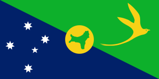
 | 2004–present | Flag of the Cocos (Keeling) Islands | The flag is green, with a palm tree on a gold disc in the canton, a gold crescent for the Cocos Malay people in the centre of the flag and a gold southern cross in the fly. The flag was designed in 2003 becoming official in 2004. [1] [2] [3] |
| Flag | Date | Use | Description |
|---|---|---|---|
 | 1878-1886 1942-1946 | Flag of British Ceylon | A defaced blue ensign with the Arms of the Ceylon Government. |
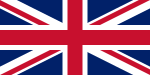 | 1886-1900 | Flag of The United Kingdom | A superimposition of the flags of England and Scotland with the Saint Patrick's Saltire (representing Ireland). |
 | 1900-1925 | Flag of The Straits Settlements | A defaced blue ensign with the arms of the Strait Settlements. |
 | 1925-1942 | Flag of The Straits Settlements | A defaced blue ensign with the arms of the Strait Settlements (without the white disc). |
 | 1946-1952 | Flag of The Colony of Singapore | A defaced blue ensign with the arms of Singapore. |
 | 1952-1955 | Flag of The Colony of Singapore | A defaced blue ensign with the arms of Singapore (slightly modified crown). |
 | 1955-2004 (Still used Today) | Flag of Australia | A Blue Ensign defaced with the seven-point Commonwealth Star in the lower hoist quarter and the five stars of the Southern Cross in the fly half. |
The Territory of Christmas Island is an Australian external territory in the Indian Ocean comprising the island of the same name. It is located approximately 350 kilometres south of Java and Sumatra and about 1,550 km (840 nmi) north-west of the closest point on the Australian mainland. It has an area of 135 square kilometres (52 sq mi). The territory derives its name from its discovery on Christmas Day 1643 by Captain William Mynors.

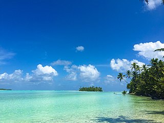
The Cocos (Keeling) Islands, officially the Territory of Cocos (Keeling) Islands, are an Australian external territory in the Indian Ocean, comprising a small archipelago approximately midway between Australia and Sri Lanka and relatively close to the Indonesian island of Sumatra. The territory's dual name reflects that the islands have historically been known as either the Cocos Islands or the Keeling Islands.

The Clunies-Ross family were the original settlers of the Cocos (Keeling) Islands, a small archipelago in the Indian Ocean. From 1827 to 1978, the family ruled the previously uninhabited islands as a private fiefdom, initially as terra nullius and then later under British (1857–1955) and Australian (1955–1978) sovereignty. The head of the family was usually recognised as the resident magistrate, and was sometimes styled as the "King of the Cocos Islands"; a title given by the press.

UTC+06:30 is an identifier for a time offset from UTC of +06:30. In ISO 8601 the associated time would be written as 2024-10-11T17:04:31+06:30. It is 6.5 hours ahead of UTC, meaning that when the time in UTC areas is midnight (00:00), the time in UTC+6:30 areas would be 6:30 in the morning.

The states and territories are the second level of government of Australia. The states are partially sovereign, administrative divisions that are self-governing polities, having ceded some sovereign rights to the federal government. They have their own constitutions, legislatures, executive governments, judiciaries and law enforcement agencies that administer and deliver public policies and programs. Territories can be autonomous and administer local policies and programs much like the states in practice, but are still legally subordinate to the federal government.
The flag of the Cocos (Keeling) Islands was created in 2003 and adopted on 6 April 2004. It was designed by territory resident Mohammed Minkom, who won a design contest as a teenager.

Cocos (Keeling) Islands Airport is an airport serving the Cocos (Keeling) Islands, a territory of Australia located in the Indian Ocean. The airport is on West Island, one of the South Keeling Islands and capital of the territory.
The Shire of Cocos (Keeling) Islands is a local government area which manages local affairs on the Australian external territory of Cocos (Keeling) Islands. The island is grouped with Western Australia but is administered by the Department of Infrastructure, Regional Development and Cities and an Administrator.
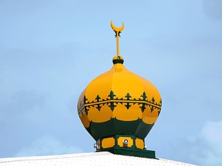
Islam in the Cocos (Keeling) Islands is the majority religion. As of the 2016 census, 75% of the population were Muslim.

Cocos Malays are a community that form the predominant group of the Cocos (Keeling) Islands, which is now a part of Australia. Today, most of the Cocos Malay can be found in the eastern coast of Sabah, Malaysia, because of diaspora originating from the 1950s during the British colonial period.
West Island, part of the South Keeling Islands, is the capital of the Cocos (Keeling) Islands, an Australian external territory in the Indian Ocean. The population is roughly 120, making it the third smallest capital in the world, and consists mainly of Europeans. It is less populous than Home Island, the only other inhabited island.

Home Island, also known locally as Pulu Selma, is one of only two permanently-inhabited islands of the 26 islands of the South Keeling Islands of the Cocos (Keeling) Islands, an Australian external territory in the central-eastern Indian Ocean.

The postage stamps and postal history of the Cocos (Keeling) Islands are linked to those of the two British colonies and of Australia to which the Indian Ocean archipelago was successively attached.

Although it is an Australian External Territory, the culture of the Cocos (Keeling) Islands has extensive influences from Malaysia and Indonesia.
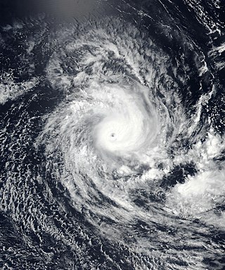
Severe Tropical Cyclone Savannah was a strong tropical cyclone that brought significant impacts to Java and Bali and minor impacts to Christmas Island and the Cocos (Keeling) Islands during March 2019. It was the sixteenth tropical low, sixth tropical cyclone and third severe tropical cyclone of the 2018–19 Australian region cyclone season. Savannah developed from a tropical low that formed well to the east of Christmas Island on 8 March. The system was slow to develop initially, but reached tropical cyclone intensity on 13 March after adopting a southwesterly track. Savannah underwent rapid intensification and reached peak intensity on 17 March as a Category 4 severe tropical cyclone on the Australian scale. Ten-minute sustained winds were estimated as 175 kilometres per hour (109 mph), with a central barometric pressure of 951 hPa (28.08 inHg). One-minute sustained winds reached 185 kilometres per hour (115 mph) at this time, equivalent to a Category 3 major hurricane on the Saffir–Simpson hurricane wind scale. Weakening commenced soon afterwards, and responsibility for the system passed from the Australian Bureau of Meteorology to Météo-France. As it moved into the new region, Savannah became the eighth of a record-breaking ten intense tropical cyclones in the 2018–19 South-West Indian Ocean cyclone season. Savannah was downgraded to a tropical depression on 20 March, and its remnants dissipated in the central Indian Ocean on 24 March.
Government House is a heritage-listed official residence at Qantas Close, West Island, Cocos (Keeling) Islands, Australia. It was added to the Australian Commonwealth Heritage List on 22 June 2004.

The COVID-19 pandemic in the Cocos (Keeling) Islands is part of the ongoing worldwide pandemic of coronavirus disease 2019 (COVID-19) caused by severe acute respiratory syndrome coronavirus 2 (SARS-CoV-2). The virus was confirmed to have reached the Cocos (Keeling) Islands on 19 March 2022.

The COVID-19 pandemic in Christmas Island is part of the ongoing worldwide pandemic of coronavirus disease 2019 (COVID-19) caused by severe acute respiratory syndrome coronavirus 2 (SARS-CoV-2). The virus was confirmed to have reached Christmas Island on 6 March 2022.