The first colonies of the British Empire on the continent of Australia were the penal colony of New South Wales, founded in 1788, and the Swan River Colony (later renamed Western Australia), founded in 1829. Over the next few decades, the colonies of New Zealand, Queensland, South Australia, Van Diemen's Land (later renamed Tasmania), and Victoria were created from New South Wales, as well as an aborted Colony of North Australia. On 1 January 1901, these colonies, excepting New Zealand, became states in the Commonwealth of Australia. Since federation, the internal borders have remained mostly stable, except for the creation of some territories with limited self-government: the Northern Territory from South Australia, to govern the vast, sparsely populated centre of the country; the split of the Northern Territory into Central Australia and North Australia, and then the quick merger of those back into the Northern Territory; and the Australian Capital Territory, a federal district ceded from New South Wales.
Outside of the continent, Queensland attempted an expansion into New Guinea, but British authorities rejected this; the claim would later be made a British protectorate and ceded to Australia. The League of Nations mandated northeast New Guinea to Australia after World War I, as well as Nauru, which was placed under joint Australian-British-New Zealand jurisdiction. These mandates (and, later, United Nations trust territories) became the independent nations of Nauru and Papua New Guinea in the mid-20th century. Australia has also obtained several small island territories, mainly from earlier British colonies, and has a large claim on Antarctica.
Key to map colours
Date | Event | Map |
---|---|---|
25 April 1787 | The Colony of New South Wales was created as a penal colony by the Kingdom of Great Britain in Australia east of 135° east. [1] Word of the establishment was proclaimed in Australia by Governor Arthur Phillip on 7 February 1788. [2] The commission included "all the islands adjacent in the Pacific Ocean" within the latitudes of 10°37' south and 43°39' south, which included most of New Zealand. [1] | |
11 July 1810 | Macquarie Island was discovered by Frederick Hasselborough, who claimed it for the United Kingdom and declared it part of New South Wales. [3] [4] | |
16 July 1825 | New South Wales was extended west to 129° east, so that it would include a trading post set up on Melville Island; and the borders of the "islands adjacent in the Pacific Ocean" were moved north to 39°12' south, now including only a small part of New Zealand. [5] | |
3 December 1825 | The southern islands of New South Wales were made the Colony of Van Diemen's Land. [6] [7] | |
2 May 1829 | A colony commonly known as the Swan River Colony was founded in the remainder of Australia outside of New South Wales. [8] Most documents calling for the colony's foundation make no mention of a name, apart from its location at the "Port on the Western Coast of New Holland, at the Mouth of the River called 'Swan River', with the adjacent Territory", [9] and that a settlement should be formed "within the Territory of 'Western Australia'". [10] However, the law calling for the creation of the colony does appear to specify that it should be called "Western Australia". [11] | |
6 February 1832 | The legal instrument required to formally appoint James Stirling governor of the Colony of Western Australia was proclaimed, and this is commonly held as the date that the Swan River Colony was renamed Western Australia. [12] [13] | |
19 February 1836 | The portion of New South Wales between 132° east and 141° east, and south of 26° south, was made the Province of South Australia. [14] The actual landing and proclamation occurred on 28 December 1836. [15] Its border with New South Wales south of the Murray River would be erroneously surveyed roughly 3.6 kilometres (2.2 mi) west of 141° east, and the resulting disputes with the colonies and, later, states that share that border would not be fully resolved until 1914. [16] | |
15 June 1839 | The islands of New Zealand were annexed to New South Wales. [17] [18] The action was proclaimed on 14 January 1840. [19] | |
16 November 1840 | The Colony of New Zealand was chartered and split from New South Wales. [20] [21] | |
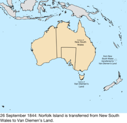
26 September 1844 | Norfolk Island was transferred from New South Wales to Van Diemen's Land. [22] | |
17 February 1846 | The half of New South Wales north of 26° south was made the Colony of North Australia. [23] [24] [25] | |
28 December 1847 | Following a change in government in the United Kingdom, North Australia was merged back in to New South Wales. [23] [25] This is the date Queen Victoria revoked the letters patent establishing North Australia, but it was not proclaimed in Australia until 16 January 1849. | |
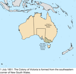
1 July 1851 | The portion of New South Wales south of the Murray River and a line from the headwaters of the river to Cape Howe was made the Colony of Victoria. [26] | |
1 January 1856 | Van Diemen's Land was renamed Tasmania, as a way to get away from its past as a penal colony. [27] | |
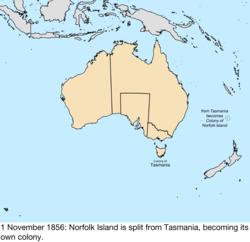
1 November 1856 | Norfolk Island was split from Tasmania, becoming its own colony. [28] Some sources say this occurred the previous day, [29] but the Norfolk Island Act 1913 states it was on this day. | |
6 June 1859 | The portion of New South Wales north of 29° south, the Dumaresq and Macintyre Rivers, and several mountain ridges, and east of 141° east, was made the Colony of Queensland. [30] | |
10 October 1861 | The portion of New South Wales west of South Australia was transferred to South Australia by letters patent. The act of parliament was passed on 22 July 1861. [31] | |
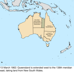
13 March 1862 | The portion of New South Wales north of South Australia and east of 138° east was transferred to Queensland. [32] | |
6 July 1863 | The region of New South Wales north of South Australia was transferred to South Australia. [33] | |
30 May 1872 | All islands lying within 60 miles (97 km) of Queensland were annexed to the colony by letters patent. [34] This was done primarily to incorporate the Torres Strait Islands, which were starting to be claimed by New South Wales. It is unknown which specific islands may have already been considered part of Queensland, and the map included with the letters patent contained errors, such as including Melville Island in Queensland. [35] | too vague to map |
21 July 1879 | The Torres Strait Islands were specifically annexed to Queensland. [34] [35] | |
17 June 1880 | Macquarie Island was made a constituent part of the Colony of Tasmania through Letters Patent for the Governor of Tasmania. [36] | |
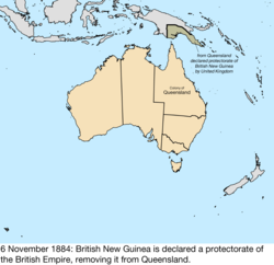
4 April 1883 | Queensland claimed southeast New Guinea as a dependency, though the British government rejected the claim. [37] | |
6 November 1884 | The British Empire declared southeast New Guinea as a protectorate, removing it from immediate Queensland control, though the colony still largely administered it. [38] |
Date | Event | Map |
---|---|---|
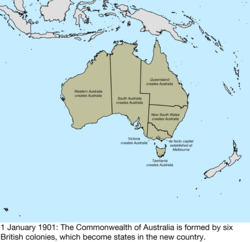
1 January 1901 | Six colonies of the United Kingdom formed the Commonwealth of Australia: [39]
Parliament met in Melbourne until the federal capital could be built. [40] | |
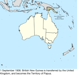
1 September 1906 | British New Guinea was transferred from the United Kingdom, becoming the Territory of Papua. [41] [42] | |
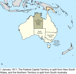
1 January 1911 | The Federal Capital Territory was split from New South Wales, [43] [44] and the Northern Territory was split from South Australia. [45] [46] While the acts creating it use the term "Territory for the Seat of Government", legislation and proclamations immediately began using the term "Federal Capital Territory." [47] | |
1 July 1914 | Norfolk Island was transferred from the United Kingdom, becoming the Territory of Norfolk Island. [28] [48] | |
4 September 1915 | A small peninsula along Jervis Bay was ceded to the Federal Capital Territory by New South Wales. [49] [50] | |
17 December 1920 | The League of Nations mandated the former German New Guinea to Australia as the Territory of New Guinea [51] [52] and the Mandate of Nauru, [53] [54] with New Zealand and the United Kingdom as co-trustees of Nauru. [55] | |
1 February 1927 | The Northern Territory was split at 20° south into the territories of Central Australia and North Australia. [56] [57] | |
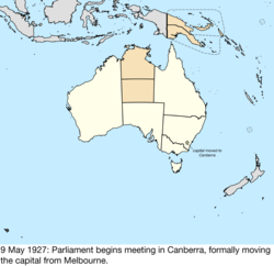
9 May 1927 | Parliament began meeting in Canberra, formally moving the capital there from Melbourne. [58] [59] | |
12 June 1931 | The territories of Central Australia and North Australia were merged to become the Northern Territory. [60] [61] | |
10 May 1934 | The Ashmore and Cartier Islands were transferred from the United Kingdom and became the Territory of Ashmore and Cartier Islands. A British order-in-council dated 23 July 1931 had stated that the islands would be placed under the authority of the Commonwealth of Australia when Australia passed legislation to accept them. [62] [63] | |
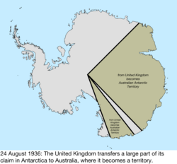
24 August 1936 | The United Kingdom transferred the portion of its claim to Antarctica between 45° east and 136° east, and 142° east and 160° east, to Australia, where it became the Australian Antarctic Territory. [64] [65] | |
29 July 1938 | The Territory of Ashmore and Cartier Islands was annexed to the Northern Territory. [66] The Federal Capital Territory was renamed the Australian Capital Territory. [67] | |
26 August 1942 | The Mandate of Nauru was captured by Japan. [68] | |
14 September 1945 | The Japanese garrison in the Mandate of Nauru surrendered. [68] | |
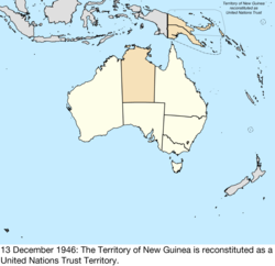
13 December 1946 | The Territory of New Guinea was reconstituted as a United Nations trust territory. [69] | |
1 November 1947 | The Mandate of Nauru was reconstituted as the United Nations Trust Territory of Nauru. [69] | |
26 December 1947 | Heard Island and McDonald Islands were transferred from the United Kingdom. The receipt was confirmed in letters exchanged on 19 December 1950. [70] | |
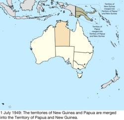
1 July 1949 | The Territory of New Guinea and Territory of Papua were merged into the Territory of Papua and New Guinea, mainly for administrative purposes; the act makes it clear that the identities of New Guinea as a United Nations Trust Territory and Papua as a possession of the Crown remain intact. [71] [72] | |
24 April 1953 | Heard Island and McDonald Islands were formally declared the Territory of Heard Island and McDonald Islands. [73] | |
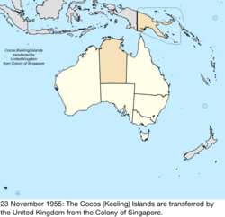
23 November 1955 | The Cocos (Keeling) Islands were transferred by the United Kingdom from the Colony of Singapore, becoming the Territory of the Cocos (Keeling) Islands. [74] [75] | |
1 October 1958 | Christmas Island was transferred by the United Kingdom from the Colony of Singapore, becoming the Territory of Christmas Island. [76] [77] | |
31 January 1968 | The Trust Territory of Nauru became independent as the Republic of Nauru. [78] [79] | |
30 September 1969 | The Coral Sea Islands Territory was created from Queensland. [80] | |
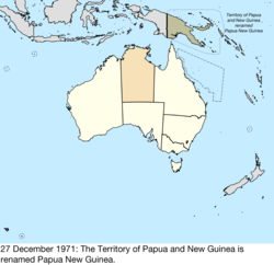
27 December 1971 | The Territory of Papua and New Guinea was renamed Papua New Guinea. [81] | |
31 December 1973 | The peninsula along Jervis Bay belonging to the Australian Capital Territory was formally named the Jervis Bay Territory; at this time, it was still considered part of the ACT. [82] | no change to map |
11 September 1975 | The Republic of the North Solomons declared the independence of the region surrounding Bougainville Island in Papua New Guinea. [83] | |
16 September 1975 | Papua New Guinea became independent as the Independent State of Papua New Guinea, [84] rendering the dispute with the Republic of the North Solomons moot. | |
1 July 1978 | The Ashmore and Cartier Islands were split from the Northern Territory, becoming the Territory of Ashmore and Cartier Islands. [85] | |
3 March 1986 | The Australia Act 1986 made Australia completely independent of the United Kingdom. [86] | no change to map |
11 May 1989 | Jervis Bay Territory was split from the Australian Capital Territory to become its own territory. [87] | |
7 July 1997 | Elizabeth Reef and Middleton Reef were transferred from New South Wales to the Coral Sea Islands Territory. [88] |
In September 2022, it was announced the border between the Australian Capital Territory and New South Wales would change for the first time since it was created in 1911. [89] ACT chief minister Andrew Barr said NSW premier Dominic Perrottet had agreed to a proposed border change for 330 hectares of land. [90]
Mabo v Queensland is a landmark decision of the High Court of Australia that recognised the existence of Native Title in Australia. It was brought by Eddie Mabo and others against the State of Queensland, and decided on 3 June 1992. The case is notable for being the first in Australia to recognise pre-colonial land interests of Indigenous Australians within the common law of Australia.
Norfolk Island is an external territory of Australia located in the Pacific Ocean between New Zealand and New Caledonia, approximately 1,412 kilometres (877 mi) east of Australia's Evans Head and about 900 kilometres (560 mi) from Lord Howe Island. Together with the neighbouring Phillip Island and Nepean Island, the three islands collectively form the Territory of Norfolk Island. At the 2021 census, it had 2,188 inhabitants living on a total land area of about 35 km2 (14 sq mi). Its capital and administrative seat is Kingston, while its main town and largest settlement is Burnt Pine.
Protected areas of Australia include Commonwealth and off-shore protected areas managed by the Australian government, as well as protected areas within each of the six states of Australia and two self-governing territories, the Australian Capital Territory and the Northern Territory, which are managed by the eight state and territory governments.
The Jervis Bay Territory is an internal federal territory of Australia. It was established in 1915 from land ceded by the state of New South Wales, in order to give the federal government access to the sea in the vicinity of the landlocked Australian Capital Territory (ACT).
The Australia Act 1986 is the short title of each of a pair of separate but related pieces of legislation: one an act of the Parliament of Australia, the other an act of the Parliament of the United Kingdom. In Australia they are referred to, respectively, as the Australia Act 1986 (Cth) and the Australia Act 1986 (UK). These nearly identical Acts were passed by the two parliaments, because of uncertainty as to whether the Commonwealth Parliament alone had the ultimate authority to do so. They were enacted using legislative powers conferred by enabling acts passed by the parliaments of every Australian state. The acts came into effect simultaneously, on 3 March 1986.
The Territory of Papua comprised the southeastern quarter of the island of New Guinea from 1883 to 1975. In 1883, the Government of Queensland annexed this territory for the British Empire. The United Kingdom Government refused to ratify the annexation but in 1884 a protectorate was proclaimed over the territory, then called British New Guinea. There is a certain ambiguity about the exact date on which the entire territory was annexed by the British. The Papua Act 1905 recites that this happened "on or about" 4 September 1888. On 18 March 1902, the Territory was placed under the authority of the Commonwealth of Australia. Resolutions of acceptance were passed by the Commonwealth Parliament, which accepted the territory under the name of Papua.
The second question of the 1967 Australian referendum of 27 May 1967, called by the Holt government, related to Indigenous Australians. Voters were asked whether to give the Commonwealth Parliament the power to make special laws for Indigenous Australians, and whether Indigenous Australians should be included in official population counts for constitutional purposes. The term "the Aboriginal Race" was used in the question.
In Australia, referendums are public votes held on important issues where the electorate may approve or reject a certain proposal. In contemporary usage, polls conducted on non-constitutional issues are known as plebiscites, with the term referendum being reserved solely for votes on constitutional changes, which is legally required to make a change to the Constitution of Australia.
Human rights in Australia have largely been developed by the democratically elected Australian Parliament through laws in specific contexts and safeguarded by such institutions as the independent judiciary and the High Court, which implement common law, the Australian Constitution, and various other laws of Australia and its states and territories. Australia also has an independent statutory human rights body, the Australian Human Rights Commission, which investigates and conciliates complaints, and more generally promotes human rights through education, discussion and reporting.
The legal system of Australia has multiple forms. It includes a written constitution, unwritten constitutional conventions, statutes, regulations, and the judicially determined common law system. Its legal institutions and traditions are substantially derived from that of the English legal system, which superseded Indigenous Australian customary law during colonisation. Australia is a common-law jurisdiction, its court system having originated in the common law system of English law. The country's common law is the same across the states and territories.
Australian nationality law details the conditions by which a person is a national of Australia. The primary law governing nationality regulations is the Australian Citizenship Act 2007, which came into force on 1 July 2007 and is applicable in all states and territories of Australia.
Australia uses three main time zones: Australian Eastern Standard Time, Australian Central Standard Time and Australian Western Standard Time.
The states and territories are the second level of government of Australia. The states are partially sovereign, administrative divisions that are self-governing polities, having ceded some sovereign rights to the federal government. They have their own constitutions, legislatures, executive governments, judiciaries and law enforcement agencies that administer and deliver public policies and programs. Territories can be autonomous and administer local policies and programs much like the states in practice, but are still legally subordinate to the federal government.
The monarchy of Australia is a key component of Australia's form of government, by which a hereditary monarch serves as the country's sovereign and head of state. It is a constitutional monarchy, modelled on the Westminster system of parliamentary democracy, while incorporating features unique to the constitution of Australia.
The United pastoral districts of Moreton, Wide Bay, Burnett and Maranoa, and from 1857 Moreton, Wide Bay, Burnett, Maranoa, Leichhardt and Port Curtis, was an electoral district of the Legislative Assembly in the Australian state of New South Wales created in 1856 and consisted of the pastoral districts around the early settlements of Moreton Bay; Wide Bay, near Maryborough; the Burnett River, near Bundaberg; and the Maranoa region of South-western Queensland. In September 1856 the pastoral districts around the Leichhardt River in the Gulf of Carpentaria region and Port Curtis (Gladstone) were added to the electorate. The district was abolished for the 1859 election and replaced by the separate districts of East Moreton, West Moreton, Burnett and Leichhardt, while Maranoa became part of Darling Downs. All of these districts became part of Queensland when it was established as a separate colony in late 1859.
Australian heritage laws exist at the national (Commonwealth) level, and at each of Australian Capital Territory, New South Wales, Northern Territory, Queensland, South Australia, Tasmania, Victoria, Western Australia state and territory levels. Generally there are separate laws governing Aboriginal cultural heritage and sacred sites, and historical heritage. State laws also allow heritage to be protected through local government regulations, such as planning schemes, as well.
The Constitution of Australia is the fundamental law that governs the political structure of Australia. It is a written constitution, that establishes the country as a federation under a constitutional monarchy governed with a parliamentary system. Its eight chapters sets down the structure and powers of the three constituent parts of the federal level of government: the Parliament, the Executive Government and the Judicature.
The Supreme Court of Christmas Island was the highest court for Christmas Island, an external territory of Australia. The court was originally established in 1958 after sovereignty over the island was transferred from the United Kingdom to Australia. The court had jurisdiction to deal with all serious crimes and major civil claims for damages occurring on the island. The court was abolished on 10 May 2002.
Suffrage in Australia is the voting rights in the Commonwealth of Australia, its six component states and territories, and local governments. The colonies of Australia began to grant universal male suffrage from 1856, with women's suffrage on equal terms following between the 1890s and 1900s. Some jurisdictions introduced racial restrictions on voting from 1885, and by 1902 most Australian residents who were not of European descent were explicitly or effectively excluded from voting and standing for office, including at the Federal level. Such restrictions had been removed by 1966. Today, the right to vote at all levels of government is held by citizens of Australia over the age of 18 years, excluding some prisoners and people "of unsound mind".
Revenge porn is the distribution of sexually explicit images or videos of individuals without their consent, with the punitive intention to create public humiliation or character assassination out of revenge against the victim. The material may have been made by an ex-partner from an intimate relationship with the knowledge and consent of the subject at the time, or it may have been made without their knowledge. The subject may have experienced sexual violence during the recording of the material, in some cases facilitated by psychoactive chemicals such as date rape drugs which also cause a reduced sense of pain and involvement in the sexual act, dissociative effects and amnesia.
An Act to provide until the Thirty-first Day of December One thousand eight hundred and thirty-four, for the Government of His Majesty's Settlements in Western Australia, on the Western Coast of New Holland