
The Tasman Sea is a marginal sea of the South Pacific Ocean, situated between Australia and New Zealand. It measures about 2,000 km (1,200 mi) across and about 2,800 km (1,700 mi) from north to south. The sea was named after the Dutch explorer Abel Janszoon Tasman, who in 1642 was the first known person to cross it. British explorer Lieutenant James Cook later extensively navigated the Tasman Sea in the 1770s during his three voyages of exploration.

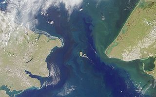
The Torres Strait, also known as Zenadh Kes, is a strait between Australia and the Melanesian island of New Guinea. It is 150 km (93 mi) wide at its narrowest extent. To the south is Cape York Peninsula, the northernmost extremity of the Australian mainland. To the north is the Western Province of Papua New Guinea. It is named after the Spanish navigator Luís Vaz de Torres, who sailed through the strait in 1606.
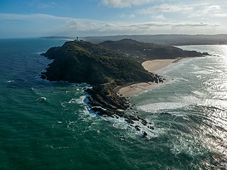
Cape Byron is the easternmost point of the mainland of Australia, located in New South Wales. It is about 3 km (1.9 mi) east of the town of Byron Bay, New South Wales and projects into the Pacific Ocean at 28.6335° S, 153.6383° E. A lighthouse is situated there. It is a popular area for hiking and for whale watching. Two national parks, one a conservation area and a marine park, are on the bay.
Cape Prince of Wales is the westernmost mainland point of the Americas. It was named in 1778 by Captain James Cook of the British Royal Navy, presumably for the Prince of Wales at the time, George Augustus Frederick. Discovered in 1732, by an expedition led by a Russian military geodesist Mikhail Gvozdev in Sviatoi Gavriil ; later, the cape was named by Vitus Bering for Gvozdev as Mys Gvozdeva. The Yupik name of the cape, published by Gavril Sarychev in 1826, was Nykhta. The current name was approved by a decision of the U.S. Board on Geographic Names in 1944.

The Furneaux Group is a group of approximately 100 islands located at the eastern end of Bass Strait, between Victoria and Tasmania, Australia. The islands were named after British navigator Tobias Furneaux, who sighted the eastern side of these islands after leaving Adventure Bay in 1773 on his way to New Zealand to rejoin Captain James Cook. Navigator Matthew Flinders was the first European to explore the Furneaux Islands group, in the Francis in 1798, and later that year in the Norfolk.

Mount Warning, a mountain in the Tweed Range in the Northern Rivers region of New South Wales, Australia, was formed from a volcanic plug of the now-gone Tweed Volcano. The mountain is located 14 kilometres (9 mi) west-south-west of Murwillumbah, near the border between New South Wales and Queensland. Lieutenant James Cook saw the mountain from the sea and named it Mount Warning.
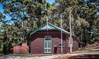
Torbay is a small town and a bay in the Great Southern region of Western Australia, 20 kilometres (12 mi) west of Albany. Torbay is within the City of Albany local government area. The Torbay townsite was gazetted in 1910.

New Holland is a historical European name for mainland Australia.
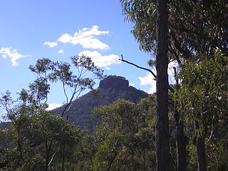
Pigeon House Mountain is a mountain at an elevation of 720 metres (2,360 ft) AHD on the Budawang Range that is situated within the Morton National Park, located on the South Coast region of New South Wales, Australia.

Kurnell is a suburb in Sydney, in the state of New South Wales, Australia. It is 21.4 kilometres (13.3 mi) south of the Sydney central business district, in the local government area of the Sutherland Shire along the east coast. Cronulla and Woolooware are the only adjacent suburbs. La Perouse is located opposite, on the northern headland of Botany Bay. The Cronulla sand dunes are on the south eastern headland of Botany Bay. The eastern side of the peninsula is part of Botany Bay National Park, and Towra Point Nature Reserve is located on the western side of the suburb.
The following lists events that happened during 1788 in Australia.

Ram Head or since 1970 Rame Head is a coastal headland in eastern Victoria, Australia. It is within the Croajingolong National Park.

Cape Hawke is a coastal headland in Australia on the New South Wales coast, just south of Forster/Tuncurry and within the Booti Booti National Park.

Cape Capricorn is a coastal headland on Curtis Island, Gladstone Region, Queensland, Australia.
The Nadgee River is a mature intermittently closed saline coastal lagoon; or perennial river located in the South Coast region of New South Wales, Australia.

Malaisia scandens, the burny vine or crow ash, is a species of large woody vines, constituting part of the fig plant family. They grow naturally in rainforests in Australia and Malesia. It is the only species in the genus Malaisia.

The second voyage of James Cook, from 1772 to 1775, commissioned by the British government with advice from the Royal Society, was designed to circumnavigate the globe as far south as possible to finally determine whether there was any great southern landmass, or Terra Australis. On his first voyage, Cook had demonstrated by circumnavigating New Zealand that it was not attached to a larger landmass to the south, and he charted almost the entire eastern coastline of Australia, yet Terra Australis was believed to lie further south. Alexander Dalrymple and others of the Royal Society still believed that this massive southern continent should exist. After a delay brought about by the botanist Joseph Banks' unreasonable demands, the ships Resolution and Adventure were fitted for the voyage and set sail for the Antarctic in July 1772.
The Cape Howe Marine National Park is a protected marine national park situated off eastern Gippsland in the far eastern tip of Victoria, Australia. The 4,050-hectare (10,000-acre) marine park extends from just east of Gabo Island to Cape Howe and the New South Wales border, and is adjacent to Croajingolong National Park.

Batemans Bay is an open oceanic embayment that is located in the South Coast region of New South Wales, Australia. The bay forms the mouth of the Clyde River and its primary outflow is to the Tasman Sea of the South Pacific Ocean.

The European exploration of Australia first began in February 1606, when Dutch navigator Willem Janszoon landed in Cape York Peninsula and on October that year when Spanish explorer Luís Vaz de Torres sailed through, and navigated, Torres Strait islands. Twenty-nine other Dutch navigators explored the western and southern coasts in the 17th century, and dubbed the continent New Holland.

