Endeavour River

Last updated

Endeavour
Endeavours
Endeavour River 2004.jpg
Endeavour River at Marton, 2004
EndeavourWiki.png
Satellite image of the Endeavour River course marked in dark blue
Etymology HMS Endeavour [1]
Native nameWabalumbaal (Guugu Yimidhirr)
Location
Country Australia
State Queensland
Region Far North Queensland
Physical characteristics
SourceEndeavour River Right Branch
  locationnorthwest of Hopevale
  coordinates 15°15′17″S145°03′01″E / 15.25472°S 145.05028°E / -15.25472; 145.05028
  elevation327 m (1,073 ft)
2nd sourceEndeavour River North Branch
  locationbelow Honeysuckle Flat
  coordinates 15°20′50″S145°06′11″E / 15.34722°S 145.10306°E / -15.34722; 145.10306
  elevation160 m (520 ft)
3rd sourceEndeavour River South Branch
  locationnear Alderbury
  coordinates 15°25′25″S144°54′54″E / 15.42361°S 144.91500°E / -15.42361; 144.91500
  elevation109 m (358 ft)
Source confluenceRight Branch to from the Endeavour River
  location Endeavour River National Park
  coordinates 15°26′34″S145°12′12″E / 15.44278°S 145.20333°E / -15.44278; 145.20333
Mouth Coral Sea
  location
Cooktown
  coordinates
15°27′23″S145°14′59″E / 15.45639°S 145.24972°E / -15.45639; 145.24972
  elevation
0 m (0 ft)
Length140 km (87 mi)
Basin size1,315 km2 (508 sq mi) to 958.6 km2 (370.1 sq mi) [2]
Discharge 
  locationNear mouth
  average24 m3/s (760 GL/a) [2]
Basin features
National park Endeavour River National Park
[3] [4] [5] [6]

The Endeavour River (Guugu Yimithirr: Wabalumbaal), inclusive of the Endeavour River Right Branch, the Endeavour River South Branch, and the Endeavour River North Branch, is a river system located on Cape York Peninsula in Far North Queensland, Australia.

Contents

Course and features

The river system comprises three branches that are sourced by runoff from the Henderson and Audaer Ranges. The river flows generally east from the Great Dividing Range to the Coral Sea. The Right Branch of the river rises northwest of Hopevale at an elevation of 335 metres (1,099 ft) and flows generally south by east for 48 kilometres (30 mi) before reaching its confluence to join with the Endeavour River northwest of Cooktown, and west of the river mouth. [4] The South Branch of the river rises near Alderbury at an elevation of 109 metres (358 ft) and flows generally east for 20 kilometres (12 mi) before forming confluence with the North Branch to form the Endeavour River. [5] The North Branch of the river rises below Honeysuckle Flat at an elevation of 160 metres (520 ft) and flows generally west and then south for 20 kilometres (12 mi) before forming confluence with the South Branch to form the Endeavour River. [6] Having been formed by the South and North Branches, the Endeavour River rises below Flaggy at an elevation of 39 metres (128 ft) and flows generally east towards its mouth with the Coral Sea at Cooktown, flowing through the Endeavour River National Park for the last few kilometres of its course. [3] The Endeavour River has a catchment area of 1,315 square kilometres (508 sq mi). [7]

In recent years, tilapia fish, which are considered an "invasive species" in Australia, have infested the river, causing concern that the stocks of native fish will suffer.

The river basin remains largely unmodified and the water quality is rated as good. [8]

History

Captain James Cook Commander, H.M.B. Endeavour, which was beached and repaired near this site 17 June - 4 August 1770 Captain Cook statue.jpg
Captain James Cook Commander, H.M.B. Endeavour, which was beached and repaired near this site 17 June – 4 August 1770

James Cook named the river in 1770 after he was forced to beach his ship, HMS Endeavour, [1] for repairs in the river mouth, after damaging it on Endeavour Reef. [9] Joseph Banks named the river the Endeavours River [10] but the form Cook used, Endeavour River, has stuck.

Cook and his crew remained for almost seven weeks and made contact with the local Guugu Yimithirr people. The naturalists Joseph Banks and Daniel Solander made extensive collections of native flora, while Sydney Parkinson illustrated much of the flora and fauna of the region. Botanical specimens were also collected by Alan Cunningham after he arrived on HMS Mermaid, captained by Philip Parker King on 28 June 1819.

Modern Cooktown which has a population of about 2,000, is located at the mouth of the Endeavour River. It is one of the northernmost towns on the east coast of Australia and was founded in 1873, around the site of Cook's landing, as a port to service the newly discovered Palmer River goldfields. Some of the relatively undisturbed natural features near the mouth of the river have been reserved in the Endeavour River National Park.

See also

Related Research Articles

<span class="mw-page-title-main">Endeavour River National Park</span> Protected area in Queensland, Australia

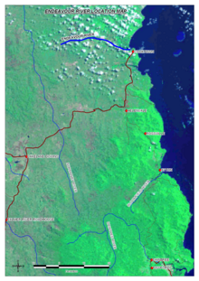
Endeavour River National Park is a national park in Queensland, Australia, gazetted to protect and preserve some of the natural and cultural resources in and around the mouth of the Endeavour River, immediately north of the small town of Cooktown. The park is located 1,561 kilometres (970 mi) northwest of Brisbane.

<span class="mw-page-title-main">Guugu Yimithirr people</span> Indigenous Australian people of Queensland

The Guugu Yimithirr, also spelt Gugu Yimithirr and also known as Kokoimudji, are an Aboriginal Australian people of Far North Queensland, many of whom today live at Hopevale, which is the administrative centre of Hopevale Shire. At the 2011 census, Hopevale had a population of 1,005 people. It is about 46 kilometres (29 mi) from Cooktown by road. It is also the name of their language. They were both a coastal and inland people, the former clans referring to themselves as a "saltwater people".

Guugu Yimithirr, also rendered Guugu Yimidhirr, Guguyimidjir, and many other spellings, is an Australian Aboriginal language, the traditional language of the Guugu Yimithirr people of Far North Queensland. It belongs to the Pama-Nyungan language family. Most of the speakers today live at the community of Hope Vale, about 46 kilometres (29 mi) from Cooktown. However, as of June 2020 only about half of the Guugu Yimithirr nation speak the language. As such, efforts are being made to teach it to children. Guugu Yimithirr is the source language of the word kangaroo.

<span class="mw-page-title-main">South Pine River</span> River in Queensland, Australia

The South Pine River is a minor river located in South East Queensland, Australia. It rises on the D'Aguilar Range and passes through the Samford Valley in the Moreton Bay Region local government area.

<span class="mw-page-title-main">Mackenzie River (Queensland)</span> Tributary of Fitzroy River in Queensland

The Mackenzie River is a river located in Central Queensland, Australia. The Mackenzie River is a major tributary of the Fitzroy River, part of the largest river catchment flowing to the eastern coast of Australia.

<span class="mw-page-title-main">Normanby River</span> River in northern Queensland, Australia

The Normanby River, comprising the East Normanby River, the West Normanby River, the East Normanby River North Branch, the East Normanby River South Branch and the Granite Normanby River, is a river system located in Far North Queensland, Australia.

<span class="mw-page-title-main">Annan River</span> River in Queensland, Australia

The Annan River is a river located in the Wet Tropics of Far North Queensland, Australia.

<span class="mw-page-title-main">Belyando River</span> River in Queensland, Australia

The Belyando River, including the Belyando River (Western Branch), is a river system located in Central Queensland, Australia. At 1,054 kilometres (655 mi) in length and with a catchment area of 35,000 square kilometres (14,000 sq mi), the Belyando River system is one of the longest rivers in Queensland.

<span class="mw-page-title-main">Johnstone River</span> River in Queensland, Australia

The Johnstone River, comprising the North Johnstone River and the South Johnstone River, is a river system located in Far North and North Queensland, Australia.

<span class="mw-page-title-main">Comet River</span> River in Queensland, Australia

The Comet River is a river located in Central Queensland, Australia.

The Kolan River is a river located in the Bundaberg Region, Queensland, Australia.

<span class="mw-page-title-main">Mulgrave River</span> River in Queensland, Australia

The Mulgrave River, incorporating the East Mulgrave River and the West Mulgrave River, is a river system located in Far North Queensland, Australia. The 70-kilometre (43 mi)-long river flows towards the Coral Sea and is located approximately 50 kilometres (31 mi) south of Cairns.

<span class="mw-page-title-main">Ward River (Central West Queensland)</span> River in Queensland, Australia

The Ward River, part of the Murray-Darling basin, is a river located in Central West Queensland, Australia.

<span class="mw-page-title-main">Cooktown, Queensland</span> Town in Queensland, Australia

Cooktown is a coastal town and locality in the Shire of Cook, Queensland, Australia. Cooktown is at the mouth of the Endeavour River, on Cape York Peninsula in Far North Queensland where James Cook beached his ship, the Endeavour, for repairs in 1770. Both the town and Mount Cook which rises up behind the town were named after James Cook.

The Tarwin River is a perennial river of the West Gippsland catchment, located in the South Gippsland region of the Australian state of Victoria. The Tarwin River is the primary river system within South Gippsland Shire and has a catchment area of approximately 1,500 square kilometres (580 sq mi), predominantly rural with small pockets of residential land use. It flows south from the Strzlecki Ranges and discharges in the eastern reaches of Anderson Inlet, a shallow estuary connected to Bass Strait.

The Yappar River is a river located in the Gulf Country region of Far North Queensland, Australia.

The Olive River is a river located in the Cape York Peninsula of Far North Queensland, Australia.

The Esk River is a river located in the Wet Tropics of Far North Queensland, Australia.

The Connors River is a river and anabranch located in Central Queensland, Australia.

The Don River is a river located in Central Queensland, Australia.

References

  1. 1 2 Shay, John; Shay, Bev (eds.). The Endeavour at the Endeavour: Cook's and Bank's journals from 11 June to 4 August 1770. Cooktown and District Historical Society.
  2. 1 2 "East Coastal Watersheds".
  3. 1 2 "Map of Endeavour River, QLD". Bonzle Digital Atlas of Australia. Retrieved 27 October 2015.
  4. 1 2 "Map of Endeavour River Right Branch, QLD". Bonzle Digital Atlas of Australia. Retrieved 27 October 2015.
  5. 1 2 "Map of Endeavour River South Branch, QLD". Bonzle Digital Atlas of Australia. Retrieved 27 October 2015.
  6. 1 2 "Map of Endeavour River North Branch, QLD". Bonzle Digital Atlas of Australia. Retrieved 27 October 2015.
  7. Howley, Christina; Brooks, Andrew; Olley, Jon; Carroll, Jason (March 2012). Annan and Endeavour River Freshwater and Estuarine Water Quality Report: An Assessment of Ambient Water Quality and Effects of Land Use: 2002 - 2009 (PDF). Cooktown, Queensland: Cape York Marine Advisory Group Incorporated. p. 11. Retrieved 23 October 2015.
  8. "Assessment of River Condition - Endeavour River". Australian Natural Resources Atlas. Department of Sustainability, Environment, Water, Population and Communities. 6 May 2009. Archived from the original on 2 June 2011. Retrieved 15 August 2011.
  9. Collingridge, Vanessa (February 2003). Captain Cook: The Life, Death and Legacy of History's Greatest Explorer. Ebury Press. ISBN   0-09-188898-0.
  10. The Endeavour Journal of Sir Joseph Banks

Bibliography