
Rebrovo Point is a point on Aktinia Beach on the southwest coast of Snow Island in the South Shetland Islands, Antarctica projecting 200 m into Boyd Strait. It is situated 2.8 km southeast of Monroe Point and 2.8 km northwest of Cape Conway, and is snow-free in summer.
Pazardzhik Point is a point on the southeast coast of Snow Island in the South Shetland Islands, Antarctica situated 2.1 km east-northeast of Cape Conway and 9.9 km southwest of Hall Peninsula. Snow-free in summer.
Irnik Point (Bulgarian: нос Ирник, ‘Nos Irnik’ \'nos ir-'nik\) is the ice-free southwest entrance point to Brauro Cove on the northwest coast of Snow Island in the South Shetland Islands, Antarctica. It is situated 3.5 km southwest of Cape Timblón, 2 km southwest of Mezdra Point, and 7.4 km northeast of Byewater Point.

Chiprovtsi Point is a point projecting 400 m (440 yd) northwestwards from the north coast of Rugged Island off the west coast of Byers Peninsula of Livingston Island in the South Shetland Islands, Antarctica, and forming the east side of the entrance to Nishava Cove. It is extended further 400 m (440 yd) northwestwards by the group of Chiprovtsi Islets, which are centred at 62°36′52″S61°16′09″W and named in association with the point.

Vardim Rocks are a group of rocks situated on the south side of Hell Gates, facing Devils Point in the southwest extremity of Byers Peninsula on Livingston Island in the South Shetland Islands, Antarctica. Extending 1.3 km (0.81 mi) in east-west direction. The two principal islets in the group, Demon and Sprite, are extending 420 by 400 m and 270 by 150 m respectively, with surface area of the former 9 hectares. The area was visited by early 19th century sealers.

Esperanto Island is the largest and northwesternmost island in the Zed group off the north coast of Varna Peninsula on Livingston Island in the South Shetland Islands, Antarctica. The island is ice-free, rocky, rising to 290 m (951 ft) and extending 950 by 900 m, with surface area 56 hectares. It is situated 70 m (77 yd) to the northwest of the neighbouring Phanagoria Island, and 2.7 km (1.7 mi) northwest of Williams Point on Livingston Island. The area was visited by early 19th century sealers.
Byewater Point is the rocky point forming the northwest extremity of Snow Island in the South Shetland Islands, Antarctica. It is a north entrance point for Boyd Strait. Elysian Beach extends 2 km easwards from the point. The area was visited by 19th century sealers.
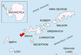
Esteverena Point is the rocky point projecting 700 m into Boyd Strait to form the west extremity of Snow Island in the South Shetland Islands, Antarctica. The feature is named by Argentina.

Barlow Island is a small ice-free island off the north coast of Smith Island in the South Shetland Islands, Antarctica extending 380 by 160 m, surface area 5.28 hectares.
Window Island is a small ice-free island off the north coast of Ray Promontory in the northwest of Byers Peninsula, Livingston Island in the South Shetland Islands, Antarctica. The island has a surface area of 23 hectares and rises to 72 m (236 ft). It was known to the early 19th century sealers operating on Byers Peninsula.

Long Rock is a large rock extending 720 m (787 yd) in east–west direction, 180 m (197 yd) wide and rising to 13 m (42.7 ft) in the northeast of Morton Strait in the South Shetland Islands, Antarctica. The area was visited by early 19th century sealers operating on Byers Peninsula.

Frederick Rocks is a group of rocks lying in Barclay Bay on the north side of Livingston Island in the South Shetland Islands, Antarctica. The area was visited by early 19th century sealers operating on nearby Byers Peninsula.
Vietor Rock is a rock linked by a spit to Nikopol Point on the south coast of Byers Peninsula, Livingston Island in the South Shetland Islands, Antarctica. The area was visited by early 19th century sealers operating on Byers Peninsula.
Eddystone Rocks is a group of two rocks lying to the northwest of Rugged Island off western Livingston Island in the South Shetland Islands, Antarctica.

Figueroa Point is an ice-free point at the northeast extremity of Greenwich Island in the South Shetland Islands, Antarctica forming the southeast side of the entrance to Galápagos Cove. Dovizio Rock is lying 190 m (210 yd) to the northeast, Ibar Rocks are centred 860 m (940 yd) to the southeast, Bonert Rock62°27′01.8″S59°42′58.3″W is 730 m (800 yd) to the south-southeast and Rosales Rocks62°26′57.5″S59°43′16.4″W are 500 m (550 yd) south by east of Figueroa Point. The area was visited by early 19th century sealers.
Mikre Beach is the beach extending 2.2 km on the southeast coast of Snow Island in the South Shetland Islands, Antarctica. It is bounded by Cape Conway to the southwest, the island's ice cap to the northwest and Pazardzhik Point to the northeast, and is snow-free in summer.

Vodoley Rock is the rock extending 220 m (720 ft) in northwest–southeast direction and 110 m (360 ft) wide in Barclay Bay on the west side of Ioannes Paulus II Peninsula on Livingston Island in the South Shetland Islands, Antarctica. The area was visited by early 19th century sealers operating on nearby Byers Peninsula and Cape Shirreff.
Aktinia Beach is the mostly ice-free 2.7 km long and 400 m wide beach extending on both sides of Rebrovo Point on the southwest coast of Snow Island facing Boyd Strait in the South Shetland Islands, Antarctica. The area was visited by early 19th century sealers.

Cacho Island is the 750 m long in northwest-southeast direction and 350 m wide rocky island separated from Hall Peninsula on the east side of Snow Island in the South Shetland Islands by a passage narrowing to just 60 m. Surface area 19 ha. It is crescent-shaped facing northeast and forming the northeast coast of Ivaylo Cove. The area was visited by early 19th century sealers.
Ogygia Island is the 420 m long in west-east direction and 70 m wide rocky island separated by a 110 m wide passage from Hall Peninsula on the east side of Snow Island in the South Shetland Islands. Surface area 2 ha. It is part of the northeast coast of Ivaylo Cove. The area was visited by early 19th century sealers.


