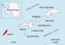

Cape Smith is a cape forming the north end of Smith Island in the South Shetland Islands, Antarctica. The discovery of the South Shetland Islands was first reported in 1819 by Captain William Smith, for whom the cape is named.
Cape Smith is a cape forming the north end of Smith Island in the South Shetland Islands, Antarctica. The discovery of the South Shetland Islands was first reported in 1819 by Captain William Smith, for whom the cape is named.
The point is located at 62°52′25.5″S62°18′00″W / 62.873750°S 62.30000°W which is 3.31 km east-northeast of Matochina Peak, 12.85 km east-northeast of Gregory Point, 4.16 km east by north of Delyan Point, 2 km east-southeast of Barlow Island and 40.5 km west-southwest of Snow Island (Bulgarian mapping in 2009).

Smith Island is 20 miles (32 km) long and 5 miles wide, lying 49 miles (79 km) west of Deception Island in the South Shetland Islands of the British Antarctic Territory. It is separated from Snow Island by the 25 miles (40 km)-wide Boyd Strait, and from Low Island by the 17 miles (27 km)-wide Osmar Strait. Surface area is 148 square kilometres (57 sq mi).

Desolation Island is one of the minor islands in the South Shetlands archipelago, Antarctica situated at the entrance to Hero Bay, Livingston Island. The island is V-shaped with its northern coast indented by Kozma Cove. Surface area is 3.12 square kilometres (1.20 sq mi).

Ivan Asen Point is a narrow rocky point projecting 680 m into Osmar Strait from the southeast coast of Smith Island in the South Shetland Islands, Antarctica. It forms the southwest side of the entrance to Ivan Asen Cove and the northeast side of the entrance to Yarebitsa Cove, and separates the glacier termini of Dragoman Glacier to the north and Armira Glacier to the south.

Cape Shirreff is a prominent cape at the north end of the rocky peninsula which separates Hero Bay and Barclay Bay on the north coast of Livingston Island, in the South Shetland Islands of Antarctica. The cape was named by Edward Bransfield in 1820 after Captain William H. Shirreff, the British commanding officer in the Pacific at that time.
Mount Christi is a mountain rising to 1,256 metres (4,121 ft) in the northern Imeon Range on Smith Island in the South Shetland Islands, Antarctica. The peak overlooks Kongur Glacier to the west-northwest, Saparevo Glacier to the north and Ritya Glacier to the southeast.
Vedena Cove is the 1.73 km wide cove indenting for 560 m the northwest coast of Smith Island in the South Shetland Islands, Antarctica west of Delyan Point. Its head is fed by Saparevo Glacier. The feature is named after Vedena River in western Bulgaria.
Garmen Point is a point on the northwest coast of Smith Island, South Shetland Islands situated 13.65 km north-northeast of Cape James, 6.12 km south-southwest of Markeli Point and 19.65 km southwest of Cape Smith. Formed by an offshoot of Mount Foster. The point is named after the settlement of Garmen in southwestern Bulgaria.
Lakatnik Point is a point on the northwest coast of Smith Island, South Shetland Islands situated 1.6 km north-northeast of Lista Point, 11 km north-northeast of Cape James, 2.66 km southwest of Garmen Point and 22 km southwest of Cape Smith. Formed by an offshoot of Neofit Peak. Bulgarian early mapping in 2008. Named after the settlement of Lakatnik in western Bulgaria.
Elin Pelin Point is a point on the northwest coast of Smith Island, South Shetland Islands situated 4.6 km north-northeast of Cape James and 4.8 km south-southwest of Lista Point. The point is named after Bulgarian writer Elin Pelin.
Krivodol Glacier is a 3.8 km long glacier on Smith Island, South Shetland Islands in Antarctica draining the southeast slopes of Imeon Range northeast and east of Antim Peak, southeast of Varshets Saddle and south of Slatina Peak. It is situated southwest of Ovech Glacier and northeast of Pashuk Glacier, and flows southeastward into Osmar Strait northeast of Sredets Point. Bulgarian early mapping in 2009. The glacier is named after the town of Krivodol in northwestern Bulgaria.
Delyan Point is a point on the northwest coast of Smith Island, South Shetland Islands forming the northeast side of the entrance to Vedena Cove. Situated 4 km west-southwest of Cape Smith, 10.66 km northeast of Markeli Point, 8.9 km east-northeast of Gregory Point, and 1.4 km northwest of Matochina Peak. Bulgarian early mapping in 2009. Named after Peter Delyan – Czar Peter II of Bulgaria, 1040-1041 AD.
Gregory Point is a rocky point on the northwest coast of Smith Island in the South Shetland Islands, Antarctica projecting 700 m into Drake Passage. Situated 12.85 km west-southwest of Cape Smith, 3.9 km northwest of Mount Pisgah and 2 km north-northeast of Markeli Point. The point was roughly charted by Captain Henry Foster in 1829 and named Cape Gregory.
Cabut Cove is the 1.08 km wide cove indenting for 1 km the northwest coast of Smith Island in the South Shetland Islands, Antarctica and entered between Markeli Point and Jireček Point. Part of its coast is formed by the terminus of Yablanitsa Glacier. The feature's name is given by Argentina.
Barlow Island is a small ice-free island off the north coast of Smith Island in the South Shetland Islands, Antarctica extending 380 by 160 m, surface area 5.28 hectares.

Window Island is a small ice-free island off the north coast of Ray Promontory in the northwest of Byers Peninsula, Livingston Island in the South Shetland Islands, Antarctica. The island has a surface area of 23 hectares and rises to 72 m (236 ft). It was known to the early 19th century sealers operating on Byers Peninsula.
Varbak Point is the ice-covered point on the southwest side of the entrance to Pakusha Cove on the southeast coast of Smith Island in the South Shetland Islands, Antarctica. The point is named after the settlement of Varbak in Northeastern Bulgaria.
Razdel Point is the ice-covered point on the southwest side of the entrance to Zapalnya Cove and northeast side of the entrance to Nikolov Cove on the southeast coast of Smith Island in the South Shetland Islands, Antarctica. The point is named after the settlements of Razdel in Northeastern and Southeastern Bulgaria.
Sredets Point is the ice-covered point on the southeast coast of Smith Island in the South Shetland Islands, Antarctica, projecting 400 m into Osmar Strait and separating the glacier termini of Krivodol Glacier to the north and Pashuk Glacier to the south.
Skalina Point is the ice-covered point on the southwest side of the entrance to Yarebitsa Cove on the southeast coast of Smith Island in the South Shetland Islands, Antarctica. It is named after the settlement of Skalina in Southern Bulgaria.
Brashlyan Cove is the 1.3 km wide cove on Osmar Strait indenting for 480 m the southeast coast of Smith Island in the South Shetland Islands, Antarctica, and entered northeast of Dupnitsa Point. Its head is fed by Gramada Glacier.
![]() This article incorporates public domain material from "Cape Smith". Geographic Names Information System . United States Geological Survey.
This article incorporates public domain material from "Cape Smith". Geographic Names Information System . United States Geological Survey.
| | This Smith Island (South Shetland Islands) location article is a stub. You can help Wikipedia by expanding it. |