Lockyer Creek

Last updated

Lockyer
Lower Lockyer Creek.jpg
Lower Lockyer Creek, 2011
Australia Queensland relief location map.jpg
Red pog.svg
Location of the Lockyer Creek mouth in Queensland
Etymology Edmund Lockyer
Location
Country Australia
State Queensland
Region South East Queensland
Cities Helidon, Grantham, Gatton
Physical characteristics
Source Great Dividing Range
  location Main Range National Park
  coordinates 27°28′6″S152°5′19″E / 27.46833°S 152.08861°E / -27.46833; 152.08861
  elevation216 m (709 ft)
Mouth confluence with the Brisbane River
  location
near Wivenhoe Pocket
  coordinates
27°24′59″S152°36′20″E / 27.41639°S 152.60556°E / -27.41639; 152.60556
  elevation
37 m (121 ft)
Length113 km (70 mi)
Basin size3,032 km2 (1,171 sq mi)
Basin features
River system Brisbane River
Tributaries 
  leftBuaraba Creek, Redbank Creek (Queensland), Sheep Creek (Queensland), Alice Creek (Queensland), Murphy's Creek
  rightPlain Creek, Laidley Creek, Sandy Creek (Queensland), Tenthill Creek, Ma Ma Creek, Flagstone Creek (Queensland), Gatton Creek
National park Main Range National Park
[1]

The Lockyer Creek is a creek in South East Queensland, Australia. A tributary of the Brisbane River, the creek is a major drainage system in the Lockyer Valley. Rising on the eastern slopes of the Great Dividing Range, the creek flows generally north-easterly for more than 100 kilometres (62 mi) before it reaches its confluence with the Brisbane River north-northeast of Lowood, and downstream from the Wivenhoe Dam. The creek is named after Edmund Lockyer. [2]

Contents

Course and features

Lockyer Creek Railway Bridge at Clarendon in 2008 Lockyer Creek Railway Bridge (Clarendon) (2008) 01.jpg
Lockyer Creek Railway Bridge at Clarendon in 2008

Draining parts of the western Scenic Rim, the creek's headwaters are in the Main Range National Park, a small sub-section of the Great Dividing Range. Its tributaries drain the slopes east of Toowoomba and areas to the north of Gatton. The total stream length of the Lockyer Creek network is 6,056 kilometres (3,763 mi). [3]

The total catchment area is 3,032 km2 (1,171 sq mi), [4] and covers nearly one quarter of the total catchment area of the Brisbane River. [2] O'Reillys Weir is located about 1 kilometre (0.62 mi) upstream from the creek's confluence with the Brisbane River. Approximately 5 kilometres (3.1 mi) upstream from the junction of Lockyer Creek and the Brisbane River is the Wivenhoe Dam. Tributaries flowing into Lockyer Creek include Flagstone Creek, Sandy Creek, Alice Creek, Laidley Creek, Tenthill Creek, Murphys Creek and Ma Ma Creek. [4]

Lower areas of the catchment have been cleared for intensive agriculture. [3] Upper parts of the catchment remain mostly forested, [3] partially protected within Lockyer National Park formerly known as White Mountain State Forest. Bushfires, soil protection, water quality and flood management are the main resource management issues for the waterway. [5] The creek is significantly degraded. The poor conditions have resulted in unstable stream banks and gully erosion from the removal of riparian vegetation. [3] [6]

Bridge at Guinn Park in 2009 Lockyer Creek Railway Bridge (Guinn Park), from SW (2009).jpg
Bridge at Guinn Park in 2009

There are a total of nine major private and public water storages within this drainage system, including Atkinson Dam, Bill Gunn Dam and Lake Clarendon. [4] The Lockyer Creek valley had been one of the driest catchments in Queensland during the recent droughts in Australia.

Flood events

During the 2011 Queensland floods, on 10 and 11 January the creek experienced severe flash flooding from overnight and daytime heavy rain in a catchment of about 2,000 square kilometres (770 sq mi). [7] During the floods the creek reached 18 metres (59 ft) deep, [8] a record that was higher than what was experienced during the 1974 Brisbane flood. [8]

The Bureau of Meteorology recorded a rise of 8 metres (26 ft) in 23 minutes during the flash flood but initially dismissed the reading as a fault. [9] It was estimated that 4,000  tonnes or 4,000 megalitres (1,100×10^6 US gal) of water per second flowed through Lockyer Creek, leading to the use of descriptive phrases such as "wall of water", or even "inland tsunami". [9] Water rose approximately 9 feet (2.7 m) above the 1893 flood level recorded at the Lockyer Creek Railway bridge (see below). Dozens of homes were destroyed and 19 people died in the floods. [10] The town of Grantham was particularly hard hit. [11]

A report by GHD Group for the Brisbane City Council suggested that flood mitigating dams on Lockyer Creek and Bremer River could be a useful measure for flood proofing Brisbane. [12]

Bridges

Railway Bridge at Gatton, 2010 Gatton Railway Bridge.JPG
Railway Bridge at Gatton, 2010

The Lockyer Creek Bridge at Bageli Park, designed by William Pagan, is one of the largest of its type in Queensland and one of Australia's first reinforced concrete arch rail bridges. [13] The bridge, built in 1910/1911, features three spans, each supported by two arches, and appeared on a stamp that was part of a series featuring landmark bridges. [14] A model of the bridge was featured in the April 2011 edition of the Australian Model Railway Magazine. [15] The bridge is still used for very heavy Brisbane bound coal and grain traffic. Another single arch bridge on the same line, but over a side gully, with the same name, is closer to Gatton and was built in 1903. [16] Further downstream in the district of Clarendon, an earlier railway structure (1885) built of timber piles with a deck of iron trusses, is possibly as spectacular. This bridge is no longer used by rail traffic. [17]

Heritage listings

Lockyer Creek has a number of heritage-listed sites, including:

See also

Related Research Articles

<span class="mw-page-title-main">Brisbane River</span> River in Queensland, Australia

The Brisbane River is the longest river in South East Queensland, Australia, and flows through the city of Brisbane, before emptying into Moreton Bay on the Coral Sea. John Oxley, the first European to explore the river, named it after the Governor of New South Wales, Sir Thomas Brisbane in 1823. The penal colony of Moreton Bay later adopted the same name, eventually becoming the present city of Brisbane. The river is a tidal estuary and the water is brackish from its mouth through the majority of the Brisbane metropolitan area westward to the Mount Crosby Weir. The river is wide and navigable throughout the Brisbane metropolitan area.

<span class="mw-page-title-main">Logan River</span> River in Queensland, Australia

The Logan River is a perennial river in the Scenic Rim, Logan and Gold Coast local government areas of the South East region of Queensland, Australia. The 184-kilometre (114 mi)-long river is one of the dominant waterways in South East Queensland that drains the southern ranges of the Scenic Rim and empties into Moreton Bay after navigating the City of Logan, a major suburban centre located south of Brisbane. The catchment is dominated by urban and agricultural land use. Near the river mouth are mangrove forests and a number of aquaculture farms.

<span class="mw-page-title-main">Warrego Highway</span> Highway in Queensland

The Warrego Highway is located in southern Queensland, Australia. It connects coastal centres to the south western areas of the state, and is approximately 715 km in length. It takes its name from the Warrego River, which is the endpoint of the highway. The entire highway is part of the National Highway system linking Darwin and Brisbane: formerly National Highway 54, Queensland began to convert to the alphanumeric system much of Australia had adopted in the early-2000s and this road is now designated as National Highway A2.

<span class="mw-page-title-main">Stanley River (Queensland)</span> River in Queensland, Australia

The Stanley River is a perennial river in the South East region of Queensland, Australia. A major tributary of the Brisbane River, the Stanley River valley extends roughly 35 kilometres (22 mi) westwards from the area south of Maleny, through Woodford to Kilcoy before veering southwards.

<span class="mw-page-title-main">Bremer River (Queensland)</span> River in Queensland, Australia

The Bremer River is a river that is a tributary of the Brisbane River, located in the Scenic Rim and Brisbane regions of South East Queensland, Australia. The 100-kilometre (62 mi)-long Bremer River drains several Scenic Rim valleys in south-east Queensland, including the Fassifern Valley, with its catchment area covering approximately 2,032 square kilometres (785 sq mi). Most valleys within the catchment have extensive river terraces. The Bremer River system is extremely degraded.

<span class="mw-page-title-main">Lockyer Valley</span> Valley in Queensland, Australia

The Lockyer Valley is an area of rich farmlands that lies to the west of Brisbane, Queensland, Australia and east of Toowoomba. The Lockyer Valley is rated among the top ten most fertile farming areas in the world, and the intensively cultivated area grows the most diverse range of commercial fruit and vegetables of any area in Australia. The valley is referred to as "Australia's Salad Bowl" to describe the area as one of Australia's premium food bowls.

<span class="mw-page-title-main">Wivenhoe Dam</span> Dam in South East Queensland

The Wivenhoe Dam is a rock and earth-fill embankment dam with a concrete spillway across the Brisbane River in South East Queensland, Australia. The dam takes it names from the local Wivenhoe Pocket rural community. The dam wall is located about 80 kilometres (50 mi) by road from the centre of Brisbane. The primary purpose of the dam is the supply of potable water for the Brisbane and Ipswich regions. The dam also provides for flood mitigation control, hydroelectricity, and recreation. The impounded reservoir is called Lake Wivenhoe and the dam, the lake and a narrow strip of surrounding land forms a locality also called Lake Wivenhoe.

<span class="mw-page-title-main">Helidon, Queensland</span> Town in Queensland, Australia

Helidon is a rural town and locality in the Lockyer Valley Region, Queensland, Australia. In the 2016 census, the locality of Helidon had a population of 1,059 people.

<span class="mw-page-title-main">Somerset Region</span> Local government area in Queensland, Australia

The Somerset Region is a local government area located in the West Moreton region of South East Queensland, Australia, about 100 kilometres (62 mi) northwest of Brisbane and centred on the town of Esk. It was created in 2008 from a merger of the Shire of Esk and the Shire of Kilcoy. It is commonly known as the Brisbane Valley, due to the Brisbane River which courses through the region, although significant parts of the region lie outside the hydrological Brisbane Valley itself.

<span class="mw-page-title-main">Clarendon, Queensland</span> Suburb of Somerset Region, Queensland, Australia

Clarendon is a rural locality in the Somerset Region, Queensland, Australia. In the 2016 census, Clarendon had a population of 244 people.

<span class="mw-page-title-main">Murphys Creek, Queensland</span> Town in Queensland, Australia

Murphys Creek is a rural town and locality in the Lockyer Valley Region, Queensland, Australia. In the 2016 census, the locality of Murphys Creek had a population of 629 people.

<span class="mw-page-title-main">2010–2011 Queensland floods</span>

A series of floods hit Queensland, Australia, beginning in November 2010. The floods forced the evacuation of thousands of people from towns and cities. At least 90 towns and over 200,000 people were affected. Damage initially was estimated at A$1 billion before it was raised to $2.38 billion. The estimated reduction in Australia's GDP is about A$30 billion. As of March 2012, there were 33 deaths attributed to the floods, with a further three people still missing.

<span class="mw-page-title-main">Spring Bluff, Queensland</span> Suburb of Toowoomba, Queensland, Australia

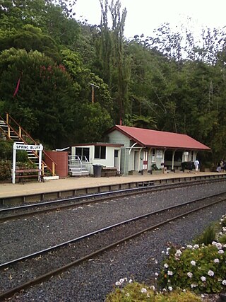
Spring Bluff is a rural locality in the Toowoomba Region, Queensland, Australia. In the 2016 census Spring Bluff had a population of 6 people.

<span class="mw-page-title-main">Brisbane Valley Rail Trail</span>

The Brisbane Valley Rail Trail (BVRT) is a 161-kilometre (100 mi) recreation trail from Wulkuraka to Yarraman in Queensland, Australia. The trail follows the old Brisbane Valley railway line and is open to walkers, touring cyclists and horse riders. The trail details the history and landscape of the Brisbane Valley. It is the longest rail trail in Queensland.

<span class="mw-page-title-main">Main Line railway, Queensland</span>

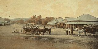
The Main Line is a railway line in South East Queensland, Australia. It was opened in a series of sections between 1865 and 1867. It commences at Roma St Station in Brisbane and extends west 161 km to Toowoomba. It is the first narrow gauge main line constructed in the world. The section of the line from the end of Murphys Creek railway station to the Ruthven Street overbridge, Harlaxton is listed on the Queensland Heritage Register. The Murphys Creek Railway Complex, the Lockyer Creek Railway Bridge (Lockyer), the Lockyer Creek Railway Bridge and Swansons Rail Bridge are also heritage listed.

<span class="mw-page-title-main">Lockyer Creek Railway Bridge (Murphys Creek)</span> Historic site in Queensland, Australia

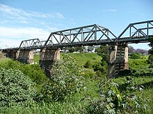
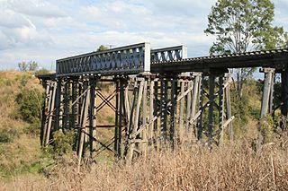
Lockyer Creek Railway Bridge (Murphys Creek) is a heritage-listed railway bridge on the Toowoomba–Helidon line over Lockyer Creek at Murphys Creek, Lockyer Valley Region, Queensland, Australia. It was designed by William Pagan and built from c. 1910 to 1911. It was added to the Queensland Heritage Register on 21 October 1992.

<span class="mw-page-title-main">Lockyer Creek Railway Bridge (Lockyer)</span> Historic site in Queensland, Australia

Lockyer Creek Railway Bridge (Lockyer) is a heritage-listed railway bridge on the Toowoomba - Helidon railway line over Lockyer Creek at Lockyer, Lockyer Valley Region, Queensland, Australia. It was designed by William Pagan and built from 1909 to 1910. It was added to the Queensland Heritage Register on 21 October 1992.

<span class="mw-page-title-main">Harlin Rail Bridge</span> Historic site in Queensland, Australia

Harlin Rail Bridge is a heritage-listed railway bridge over Ivory Creek at Harlin, Somerset Region, Queensland, Australia. It was designed by Queensland Railways and built in 1910 by Queensland Railways. It was added to the Queensland Heritage Register on 27 November 2008. It was destroyed in 2013 as a consequence of flooding associated with Cyclone Oswald.

<span class="mw-page-title-main">Yimbun Railway Tunnel</span> Historic site in Queensland, Australia

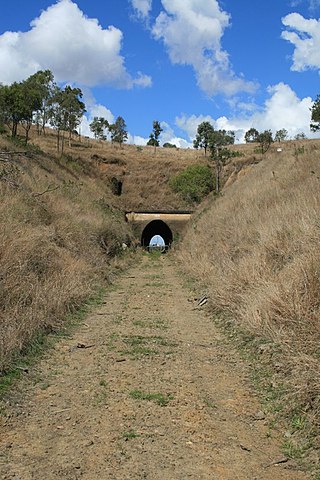
Yimbun Railway Tunnel is a heritage-listed tunnel at Sinnamons Lane, Harlin, Somerset Region, Queensland, Australia. It was designed by Queensland Railways and built from 1909 to 1910 by Queensland Railways. It was added to the Queensland Heritage Register on 27 November 2008.

Gatton–Clifton Road is a continuous 63.1 kilometres (39.2 mi) road route in the Lockyer Valley and Toowoomba regions of Queensland, Australia. Most of the road is signed as State Route 80. Gatton–Clifton Road is a state-controlled road, part regional and part district. The district part is rated as a local road of regional significance (LRRS).

References

  1. "Map of Lockyer Creek, QLD". Bonzle Digital Atlas of Australia. Retrieved 24 September 2015.
  2. 1 2 "Lockyer Creek". (Department of Environment and Resource Management. 28 September 2009. Archived from the original on 8 January 2010. Retrieved 19 May 2011.
  3. 1 2 3 4 "Lockyer Creek Catchment". Ecosystem Health Monitoring Program. Healthy Waterways. 2010. Retrieved 19 May 2011.
  4. 1 2 3 "Surface Water Management Area: Lockyer River". Australian Natural Resources Atlas. Commonwealth of Australia. 16 November 2007. Archived from the original on 29 July 2008. Retrieved 28 April 2008.
  5. South East Queensland Regional Strategy Group, Strategic Guide to Resource Management in South East Queensland, November 2000. p 102.
  6. "Lockyer Catchment" (PDF). Healthy Waterways. 2014. Retrieved 24 September 2015.
  7. "Lockyer Valley flash floods death toll now at 13, after five more bodies found, dozens still missing". The Courier Mail . Queensland Newspapers. 11 January 2011. Retrieved 11 January 2011.
  8. 1 2 Koch, Tony (12 January 2011). "Lockyer Creek became a raging torrent". The Australian. News Limited. Retrieved 19 May 2011.
  9. 1 2 Marriner, Cosima (1 May 2011). "The day a deadly torrent struck without warning". Sydney Morning Herald. Fairfax Media. Retrieved 19 May 2011.
  10. Daly, Jon; Hewson, Georgie; Moodie, Anthea (26 February 2022). "Heartbroken Lockyer Valley residents relive trauma of 2011 floods as homes, businesses go under again". ABC News . Australian Broadcasting Corporation . Retrieved 15 May 2023.
  11. Haffenden, Damien (11 January 2020). "Queensland floods of 2011: The crisis that killed 33 people and devastated communities". 7news. Retrieved 15 May 2023.
  12. Vogler, Sarah (3 May 2011). "Dams mooted for Bremer River, Lockyer Creek". The Courier-Mail. News Queensland. Retrieved 19 May 2011.
  13. 1 2 "Lockyer Creek Railway Bridge (Guinn Park) (entry 600515)". Queensland Heritage Register . Queensland Heritage Council. Retrieved 13 January 2011.
  14. "Australia Post Stamps: Landmark Bridges". Australia Post. Archived from the original on 11 September 2007. Retrieved 27 January 2008.
  15. "Lockyer Creek Bridge 1". Qldrail.net. 19 January 2011. Retrieved 26 March 2011.
  16. Queensland Environmental Protection Agency, Heritage Trails of the Great South East, State of Queensland, 2000 p.60. ISBN   0-7345-1008-X
  17. "Community Directory – Lowood District Community Website". Lowood District Community. Archived from the original on 20 August 2011. Retrieved 26 March 2011.
  18. "Lockyer Creek Railway Bridge (Lockyer) (entry 600513)". Queensland Heritage Register . Queensland Heritage Council. Retrieved 10 July 2013.
  19. "Lockyer Creek Railway Bridge (Clarendon) (entry 600495)". Queensland Heritage Register . Queensland Heritage Council. Retrieved 1 August 2014.