
"St Anthony's School". Retrieved 21 December 2021.{{cite web}}: CS1 maint: url-status (link)
Chermside West is a suburb in the City of Brisbane, Queensland, Australia. In the 2016 census Chermside West had a population of 6,458 people. Parts of Chermside West were formerly known as Craigslea.
Nundah is an inner suburb in the City of Brisbane, Queensland, Australia. It contains the neighbourhood of Toombul. In the 2016 census, Nundah had a population of 12,141 people.

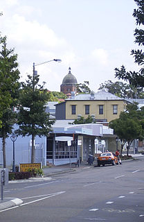
Stafford is a suburb in the City of Brisbane, Queensland, Australia. In the 2016 census Stafford had a population of 6,561 people.

Kalinga is a suburb in the City of Brisbane, Queensland, Australia. In the 2016 census Kalinga had a population of 2,126 people.

Hendra is a suburb of the City of Brisbane, Queensland, Australia. In the 2016 census, Hendra had a population of 4,625 people.

The Airport Link is a tunnelled, motorway grade, toll road in the northern suburbs of Brisbane, Queensland, Australia. It connects the Brisbane central business district and the Clem Jones Tunnel to the East-West Arterial Road which leads to the Brisbane Airport. It was built in conjunction with the Windsor to Kedron section of the Northern Busway in approximately the same corridor.

Kalinga Park is a heritage-listed park at 100 Bertha Street, Kalinga, City of Brisbane, Queensland, Australia. The eastern section of the park is in neighbouring Clayfield. It is also known as Anzac Memorial Park. It was added to the Queensland Heritage Register on 3 July 2007.

Nudgee is a north-eastern suburb in the City of Brisbane, Queensland, Australia. In the 2016 census, Nudgee had a population of 3,578 people.

Nudgee Beach is a suburb and beach in the City of Brisbane, Queensland, Australia. In the 2016 census, the suburb had a population of 263 people.

Bramble Bay is an embayment of Moreton Bay in South East Queensland, Australia. The Brisway map reference is 12 H5, or see page 91 G19 in Refidex.
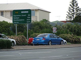
Gympie Road is a major road in the northern suburbs of Brisbane, Queensland, Australia. The road forms part of the main road route from the Brisbane Central Business District (CBD) to the northern suburbs, Sunshine Coast and east coast of Queensland.
The Kedron Brook is a brook that flows through the northern suburbs of Brisbane in the south-east region of Queensland, Australia.
Sandgate Road is a major road in Brisbane, Queensland, Australia. It provides part of the road connection between Redcliffe and the Brisbane CBD. It is designated state route 26 throughout most of its length.

Eagle Junction is a former suburb of Brisbane, Queensland, Australia. It is now a neighbourhood within the suburb of Clayfield.

The Town of Hamilton is a former local government area of Queensland, Australia, located in north-eastern Brisbane.
The Shire of Kedron is a former local government area of Queensland, Australia, located in northern Brisbane. It existed between 1879 and 1925.

The Kedron Division is a former local government area of Queensland, Australia, located in northern Brisbane.

The Shire of Toombul was a local government area of Queensland, Australia, located in northern Brisbane from 1883 to 1925.
The electoral district of Toombul was a Legislative Assembly electorate in the state of Queensland, Australia.