Enoggera Dam

Last updated

Enoggera Dam
Enoggera-Reservoir.JPG
Enoggera Dam, at the Brisbane Forest Park, in 2007
Australia Queensland relief location map.jpg
Red pog.svg
Location of Enoggera Dam in Queensland
CountryAustralia
Location South East Queensland
Coordinates 27°26′50″S152°55′37″E / 27.4473°S 152.927°E / -27.4473; 152.927 Coordinates: 27°26′50″S152°55′37″E / 27.4473°S 152.927°E / -27.4473; 152.927
StatusOperational
Construction began1864
Opening date1866
Construction cost£71,000
Dam and spillways
Type of dam Clay cored earthfill dam
Impounds Enoggera Creek
Height23.5 m (77 ft) [1]
Length475 m (1,558 ft) [1]
Dam volume360×10^3 m3 (13×10^6 cu ft) [1]
Spillway type Uncontrolled
Spillway capacity450 m3/s (16,000 cu ft/s) [1]
Reservoir
CreatesEnoggera Reservoir
Total capacity4,567 ML (1,005×10^6 imp gal; 1,206×10^6 US gal) [1]
Catchment area 33 km2 (13 sq mi) [1]
Surface area75 ha (0.75 km2)
Maximum length2,376 m (7,795 ft)
Maximum width640 m (2,100 ft)

The Enoggera Dam is a heritage-listed dam, which is located within the outer, western suburb of Enoggera Reservoir, in Brisbane, Queensland, Australia.

Contents

History

The Enoggera Dam was constructed in 1866, on the upper reach of Breakfast Creek (which section was later renamed Enoggera Creek). It was the first major dam built in Queensland and the second major dam built in Australia  (the first major dam, Yan Yean Reservoir having been built in Victoria in 1850). [2] It is rare as one of the few remaining examples in Queensland of an intact and functioning reservoir and treatment plant from this period in time. The clay-cored earth-fill dam was designed and built by Joseph Brady. [2] [3]

Water supply problems plagued Brisbane's early years. Soon after the Brisbane Municipal Council was established in 1860, a Water Supply Committee was formed. [4] The earliest reservoir in Brisbane, which was located on the present Law Courts precinct at the intersection of George, Roma and Turbot Streets, suffered from accumulation of dead animals and vegetable matter. [4]

Site selection

Breakfast Creek was rejected by the Water Supply Committee because it was too close to the town. [4] Thomas Oldham, an engineer who had worked on water supply to Melbourne, was employed to conduct a survey and solve Brisbane's problems.

One of Oldham's site recommendations on the Brisbane River near Dutton Park was dismissed because of its prohibitive costs. [4] The other site Oldham suggested was selected because it was where Enoggera Creek left the range. [5] The Surveyor-General, Augustus Gregory also suggested a site on Ithaca Creek. This location was abandoned because it had a small catchment size.

Enoggera Creek had a large catchment that rose higher in the D'Aguilar Range and had more smaller creeks flowing into it. [5] The location was steep and heavily timbered. It took eighteen months and ten different contractors to just clear the site. [5]

Construction

A hand coloured postcard showing picnickers around the turn of the 20th century. StateLibQld 1 106020 Picnic at Enoggera Reservoir, Brisbane.jpg
A hand coloured postcard showing picnickers around the turn of the 20th century.

The Queensland Government didn't have confidence in the Council to supervise the dam's construction. After requesting revised plans and detailed cost estimates the Board of Waterworks was established to oversee the project. [4]

Approval for the dam's construction was given in May 1864. Work began in August 1864, with water flowing by July 1866. [6]

A single wrought-iron mains pipe, 8 inches (20 cm) in diameter (in lieu of the 20 inches (51 cm) in diameter originally proposed by Oldham) supplied the town of Brisbane . The pipe arrived at Roma Street, with branch pipes from there to various parts of the town. By 1869 the pipelines were extended to a total of eighteen kilometers, benefiting between five and six thousand people. [5]

Three outlet pipes were incorporated into the design instead of the usual one or two. [2] This allowed the potential supply to increase if needed as well as providing some safety benefits. [2]

The original cost was £50,000, which was raised to £65,000. [6] By the end of 1870 more than £71,000 had been spent and water supply for the rapidly growing city of Brisbane was not being met by strong demand. To solve the problem another dam, Gold Creek Dam was approved in 1881.

A commemorative drinking fountain in the City Botanic Gardens is dedicated to the arrival of clean drinking mains water to Brisbane. [2]

Droughts and floods

Dry periods pronounced water quality problems in both Enoggera Dam and Gold Creek Dam built after the Enoggera reservoir was completed. The Mount Crosby Weir and pumping station alleviated some concerns but flooding of the Brisbane River was problematic. It was not until 1912 that water from Enoggera Dam was filtered. [7]

A spillway was added in 1976. [3] Seven metres was added to the height of the dam wall for flood mitigation in the same year. [5]

It was decommissioned in 2003, then in early 2006 water from Enoggera Dam was again added to inner north-west Brisbane's drinking water supply, when drought had reduced South East Queensland's water supply to critical levels.

During the 2022 Eastern Australia floods, Enoggera Dam reached a capacity of 270%, leading to severe flooding in the Enoggera Creek catchment.

Current use

Recreational use of Enoggera Dam, 2015 Recreational use of Enoggera Dam, 2015 02.jpg
Recreational use of Enoggera Dam, 2015

The dam was managed by the Brisbane City Council until July 2008, until it was transferred to Seqwater in a region-wide redistribution of water assets. During summer the recreational area is a popular place for local families to escape the heat.

There are walking tracks in the area, and no permit is required. In March 2014, Seqwater released a recreation guide that allowed for water activities including swimming, canoeing, kayaking and fishing with a licence. [8] The public recreational area is divided into areas for wading and for the launching of watercraft. Public access to the dam is via Walkabout Creek Wildlife Centre.

Heritage listing

The dam was listed on the Queensland Heritage Register in 2007. [3]

See also

Related Research Articles

DAguilar Range

The D'Aguilar Range is a mountain range near Brisbane, Queensland, Australia. The town of Dayboro is situated on the lower foothills midway along the range and the Sunshine Coast Hinterland town of Mooloolah lies at the northernmost point of the range. Many residential areas line its eastern slopes including the town of Samford and the suburb of Ferny Hills. In the west, numerous ridges and gullies are heavily forested and designated as state forest or national park.

Somerset Dam Dam in South East Queensland

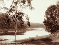
The Somerset Dam is a mass concrete gravity dam with a gated spillway across the Stanley River in Queensland, Australia. It is within the locality of Somerset Dam in the Somerset Region in South East Queensland. The main purpose of the dam is the supply of potable water for the Brisbane, Gold Coast and Logan City regions. Additionally, the dam provides for flood mitigation, recreation and for the generation of hydroelectricity. The impounded reservoir is called Lake Somerset.

Brisbane Forest Park Protected area in Queensland, Australia

Brisbane Forest Park, is located on parts of the D'Aguilar Range. The large nature reserve lies on the western boundary of City of Brisbane into the Moreton Bay Region, Queensland, Australia, in Enoggera Reservoir, adjacent to The Gap and between the Mount Coot-tha Reserve on the Taylor Range and higher peaks to the north. Brisbane Forest Park supports plants and animals and is essential to their survival. The main entrance is located in the suburb of The Gap although there are a number of other access points.

Wivenhoe Dam Dam in South East Queensland

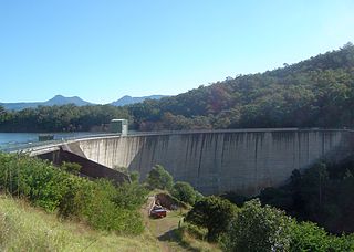
The Wivenhoe Dam is a rock and earth-fill embankment dam with a concrete spillway across the Brisbane River in South East Queensland, Australia. The dam wall is located about 80 kilometres (50 mi) by road from the centre of Brisbane. The primary purpose of the dam is the supply of potable water for the Brisbane and Ipswich regions. In addition, the dam also provides for flood mitigation control, hydroelectricity and for recreation. The impounded reservoir is called Lake Wivenhoe and the dam, the lake and a narrow strip of surrounding land forms a locality also called Lake Wivenhoe.

Moogerah Dam Dam in South East Queensland

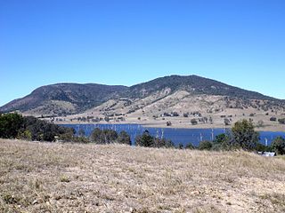
The Moogerah Dam is a mass concrete double curvature arch dam with an un-gated spillway across the Reynolds Creek that is located in the South East region of Queensland, Australia. The main purposes of the dam are for irrigation of the Reynolds Creek and for supply of potable water to Warrill Creek and farmers in the Warrill Valley. The impounded reservoir is called Lake Moogerah.

Leslie Harrison Dam Dam in South East Queensland

The Leslie Harrison Dam is an earth-fill embankment dam across the Tingalpa Creek that is located in the South East region of Queensland, Australia. The main purpose of the dam is for potable water supply of the Redland City in Brisbane. The impounded reservoir is called Tingalpa Reservoir. The dam was named after Robert Leslie Harrison, a Queensland parliamentarian who died in April 1966.

North Pine Dam Dam in South East Queensland

The North Pine Dam is a mass concrete gravity dam with earth-fill embankments on abutments with a gated spillway across the North Pine River that is located in the South East region of Queensland, Australia. The main purpose of the dam is for supply of potable water for the Moreton Bay region and Brisbane's northern suburbs. The impounded reservoir is called Lake Samsonvale.

Enoggera Reservoir, Queensland Suburb of Brisbane, Queensland, Australia

Enoggera Reservoir is an outer north-western suburb in the City of Brisbane, Queensland, Australia. In the 2016 census, Enoggera Reservoir had a population of 25 people.

North Pine River

The North Pine River is a minor river located in South East Queensland, Australia.

The Sideling Creek Dam is an earth-fill embankment dam with an un-gated spillway across the Sideling Creek in Kurwongbah, Moreton Bay Region, Queensland, Australia. The main purposes of the dam are for potable water supply of the Moreton Bay Region and for recreation. The impounded reservoir is called Lake Kurwongbah.

Gold Creek Dam Dam in South East Queensland

The Gold Creek Dam is an earth-fill embankment dam with an un-gated spillway across the Gold Creek that is located in the South East region of Queensland, Australia. The main purpose of the dam is for potable water supply of the Brisbane region. The resultant reservoir is called the Gold Creek Reservoir.

Baroon Pocket Dam Dam in South East Queensland

The Baroon Pocket Dam is a rock and earth-fill embankment dam with an un-gated spillway across the Obi Obi Creek, in North Maleny, Sunshine Coast Region, in South East Queensland, Australia. The main purpose of the dam is for potable water supply. The impounded reservoir is called Lake Baroon.

Lake Manchester Dam is a concrete gravity dam with an un-gated spillway across Cabbage Tree Creek. It is also known as Cabbage Tree Creek Dam. It is in the locality of Lake Manchester, City of Brisbane, Queensland, Australia. The main purpose of the dam is for potable water supply of Brisbane. The impounded reservoir is called Lake Manchester.

Six Mile Creek Dam Dam in South East Queensland

The Six Mile Creek Dam is a rock and earth-fill embankment dam with an un-gated spillway across the Six Mile Creek that is located in the South East region of Queensland, Australia. The main purposes of the dam are for potable water supply of the Sunshine Coast region and for recreation. The impounded reservoir is called Lake Macdonald, named in memory of former Noosa Shire Council Chairman Ian MacDonald.

Breakfast Creek

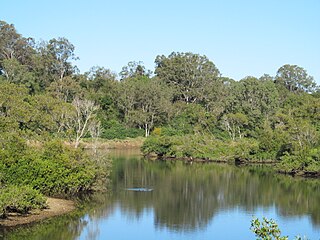
The Breakfast Creek is a small urban stream that is a tributary of the Brisbane River, located in suburban Brisbane in the South East region of Queensland, Australia.

SEQ Water Grid

The SEQ Water Grid is a region-wide, long term, water supply scheme that provides a sustainable water infrastructure network for the South East region of Queensland, Australia. The project was the largest urban response to the drought in Australia, which severely affected water supplies in Brisbane and surrounds, particularly between 2004 and 2007. The basic component of the project was a 535-kilometre (332 mi) network of potable bulk water pipelines that connect areas that have an oversupply of water to those areas lacking water. The project went online in October 2008 and by November 2008 parts of the region were receiving a diversified supply of water for the first time.

The Mount Crosby Weir is a heritage-listed weir on the Brisbane River at Mount Crosby and Chuwar, both in City of Brisbane, Queensland, Australia. The project was instigated by John Petrie at the end of the 19th century. The town of Brisbane was expanding and seeking more reliable sources of drinking water than Enoggera Dam and Gold Creek Dam could provide. In conjunction with the Mount Crosby Pumping Station, it was listed on the Queensland Heritage Register on 25 October 2019.

Enoggera Creek Creek in Queensland, Australia

Enoggera Creek is a creek which flows through the City of Brisbane in South-East Queensland, Australia.

Spring Hill Reservoirs

The Spring Hill Reservoirs are two heritage-listed former underground water storage reservoirs within Wickham Park at 230 Wickham Terrace, Spring Hill, City of Brisbane, Queensland, Australia. They are also known as Service Reservoirs. They were added to the Queensland Heritage Register on 21 October 1992.

Paddington Water Tower Water tower in Paddington, Queensland

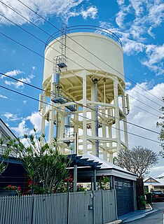
Paddington Water Tower is a heritage-listed water tower at 16 Garfield Drive, Paddington, City of Brisbane, Queensland, Australia. It was designed by Metropolitan Water Supply & Sewerage Board and built by day labour in 1927. It was added to the Queensland Heritage Register on 23 June 2000.

References

  1. 1 2 3 4 5 6 "Register of Large Dams in Australia" (Excel (requires download)). Dams information. Australian National Committee on Large Dams. 2010. Retrieved 4 July 2014.
  2. 1 2 3 4 5 Gregory, Helen; Dianne Mclay (2010). Building Brisbane's History: Structure, Sculptures, Stories and Secrets. Warriewood, New South Wales: Woodslane Press. pp. 192–194. ISBN   9781921606199.
  3. 1 2 3 "Enoggera Reservoir (entry 602458)". Queensland Heritage Register . Queensland Heritage Council. Retrieved 6 July 2013.
  4. 1 2 3 4 5 Brisbane 150 Stories. Brisbane City Council Publication. 2009. pp. 12–13. ISBN   978-1-876091-60-6.
  5. 1 2 3 4 5 Horton, Helen (1988). Brisbane's Back Door: The story of the D'Aguilar Range. Bowen Hills, Queensland: Boolarong Publications. pp. 74–77. ISBN   0-86439-036-X.
  6. 1 2 Laverty, John (2008). Carolyn Fitz-Gerald (ed.). "The politics of Brisbane's early water supply schemes". Brisbane:Water, Power and Industry Paper No. 20. Kelvin Grove, Queensland: Brisbane History Group: 23–25. ISBN   978-0-9751793-3-8.
  7. Oliver, Bill (2008). Carolyn Fitz-Gerald (ed.). "Floods, water quality and river crossings, Mount Crosby 1890-1931". Brisbane:Water, Power and Industry Paper No. 20. Kelvin Grove, Queensland: Brisbane History Group: 33. ISBN   978-0-9751793-3-8.
  8. "Enoggera Dam" (PDF). Seqwater. Retrieved 20 January 2015.

Commons-logo.svg Media related to Enoggera Reservoir at Wikimedia Commons