Bowen is a coastal town and locality in the Whitsunday Region, Queensland, Australia. In the 2016 census, the locality of Bowen had a population of 10,377 people.

Airlie Beach is a coastal locality and resort town in the Whitsunday Region of Queensland, Australia. In the 2016 census, Airlie Beach had a population of 1,208 people.
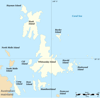
The Whitsunday Islands are 74 continental islands of various sizes off the central coast of Queensland, Australia, 900 kilometres north of Brisbane. The northernmost of the islands are off the coast by the town of Bowen, while the southernmost islands are off the coast by Proserpine. The island group is centred on Whitsunday Island, while the commercial centre is Hamilton Island. The traditional owners of the area are the Ngaro people and the Gia people, whose Juru people has the only legally recognised native title in the Whitsunday Region.

Shute Harbour is a coastal locality and harbour in the Whitsunday Region of Queensland, Australia. It has port facilities and transport options for people seeking to access the Whitsunday Islands and holiday destinations.

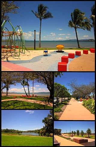
Proserpine is a rural town and locality in the Whitsunday Region, Queensland, Australia. In the 2021 census, the locality of Proserpine had a population of 3,614 people.

Collinsville is a rural town and locality in the Whitsunday Region, Queensland, Australia. In the 2021 census, Collinsville had a population of 1,496 people.

Whitsunday Coast Airport, also known as Proserpine Airport, is located in Gunyarra, Queensland, Australia, 14 kilometres (8.7 mi) south of Proserpine. The airport serves the mainland and offshore islands with flights to Brisbane, Sydney and Melbourne (Jetstar).

The Shire of Whitsunday was a local government area located in the North Queensland region of Queensland, Australia. The shire, administered from the town of Proserpine, covered an area of 2,678.3 square kilometres (1,034.1 sq mi), and existed as a local government entity from 1910 until 2008, when it amalgamated with the Shire of Bowen to form the Whitsunday Region.

The Proserpine rock-wallaby is a species of rock-wallaby restricted to a small area in Conway National Park, Dryander National Park, Gloucester Island National Park, and around the town of Airlie Beach, all in Whitsunday Shire in Queensland, Australia. It is a threatened species, being classified by the IUCN as endangered.

Water restrictions have been enacted in many cities and regions in Australia, which is the Earth's driest inhabited continent, in response to chronic water shortages resulting from the widespread drought. Depending upon the location, these can include restrictions on watering lawns, using sprinkler systems, washing vehicles, hosing pavement, refilling swimming pools, etc. Overpopulation, evidence of drying climates, coupled with corresponding reductions in the supply of drinking water has led various state governments to consider alternative water sources to supplement existing sources, and to implement "water inspectors" who can issue penalties to those who waste water. Many states describe the different levels of water restrictions in terms of "stages": starting at Stage 1, for the least restrictive, going up as far as Stage 8. The highest level reached in the current drought has been stage 7 for Kingaroy. There are different definitions given to each "stage" in different states.

The Whitsunday Region is a local government area located in North Queensland, Australia. Established in 2008, it was preceded by two previous local government areas with a history extending back to the establishment of regional local government in Queensland in 1879.
Cania Dam is a dam in central Queensland, Australia, 37 kilometres (23 mi) north west of Monto, in the locality of Cania. The dam is situated on Three Moon Creek, a tributary of the Burnett River. The dam wall is an earth and rock-fill embankment type. It has a surface area of 7.6 square kilometres, an average depth of 12 metres (39 ft) and a capacity of 88,580 ML. The dam is named after the abandoned gold mining town of Cania, which was inundated by the lake as it filled.

Cannonvale is a coastal locality and town in the Whitsunday Region, Queensland, Australia. In the 2016 census Cannonvale had a population of 5,716 people.

St Paul's Anglican Church is a heritage-listed church at 8 Main Street, Proserpine, Whitsunday Region, Queensland, Australia. It was designed by Eddie Oribin and built from 1958 to 1959 by Les Tinsley & Co. It is also known as St Paul's Anglican Memorial Church and Proserpine Church of England. It was added to the Queensland Heritage Register on 11 October 2013.
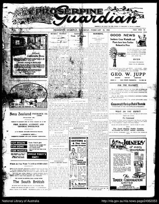
The Whitsunday Coast Guardian is a newspaper published in Proserpine, Whitsunday Region, Queensland, Australia.
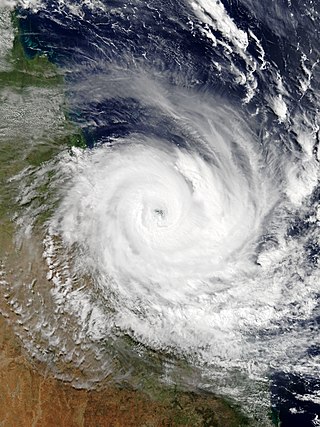
Severe Tropical Cyclone Debbie in 2017 was the strongest tropical cyclone to strike Queensland since Marcia in 2015, and was the costliest tropical cyclone in Australia since Yasi in 2011. Forming as a tropical low on 23 March, the low gradually intensified into a named tropical cyclone on 25 March. After steadily strengthening offshore to a Category 4 system, Debbie eventually made landfall near Airlie Beach, at 12:40 AEST on 28 March. Afterwards, Debbie rapidly weakened into a tropical low by late 28 March, but continued to travel south, causing significant damage and flooding in the populous areas of South East Queensland and Northern Rivers. In total, the storm caused A$3.5 billion (US$2.67 billion) in damage and fourteen deaths across Australia, primarily as a result of extreme flooding. This makes Debbie the deadliest cyclone to hit Australia since Fifi in 1991.
Mount Marlow is a rural locality in the Whitsunday Region, Queensland, Australia. In the 2016 census Mount Marlow had a population of 132 people.
Lake Proserpine is a rural locality in the Whitsunday Region, Queensland, Australia. In the 2016 census, Lake Proserpine had a population of 9 people.
Preston is a rural locality in the Whitsunday Region, Queensland, Australia. In the 2021 census, Preston had a population of 346 people.
Proserpine–Shute Harbour Road is a continuous 34.3 kilometres (21.3 mi) road route in the Whitsunday local government area of Queensland, Australia. The route is designated as State Route 59. It is a state-controlled regional road.

