
The Eildon Dam is a rock and earth-fill embankment dam with a controlled spillway, located on the Goulburn River between the regional towns of Mansfield and Eildon within Lake Eildon National Park, in the Alpine region of Victoria, Australia. The dam's purpose is for the supply of potable water, irrigation, and the generation of hydroelectricity. The impounded reservoir is called Lake Eildon.The first cut of ground was done by Mr Bain and Mr MacLean from Scotland.

The Somerset Dam is a mass concrete gravity dam with a gated spillway across the Stanley River in Queensland, Australia. It is within the locality of Somerset Dam in the Somerset Region in South East Queensland. The main purpose of the dam is the supply of potable water for the Brisbane, Gold Coast and Logan City regions. Additionally, the dam provides for flood mitigation, recreation and for the generation of hydroelectricity. The impounded reservoir is called Lake Somerset.
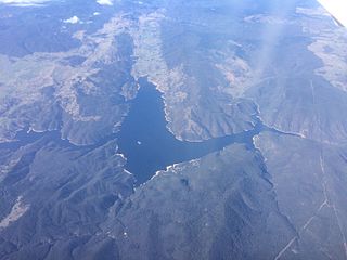
Burrinjuck Dam is a gated, concrete-walled hydro-electric gravity dam at Burrinjuck, in the South West Slopes region of New South Wales, Australia. It has three spillways across the Murrumbidgee River and forms an impounded reservoir called Lake Burrinjuck. In addition to electricity generation, Burrinjuck Dam is used for purposes including flood mitigation, irrigation, water supply and conservation. Also known as Barren Jack Dam and Barrenjack, it was added to the New South Wales State Heritage Register on 2 April 1999.

The Hinze Dam is a rock and earth-fill embankment dam with an un-gated spillway across the Nerang River in the Gold Coast hinterland of South East, Queensland, Australia. The main purpose of the dam is for potable water supply of the Gold Coast region. The impounded reservoir is called Advancetown Lake.

The Wivenhoe Dam is a rock and earth-fill embankment dam with a concrete spillway across the Brisbane River in South East Queensland, Australia. The dam takes it names from the local Wivenhoe Pocket rural community. The dam wall is located about 80 kilometres (50 mi) by road from the centre of Brisbane. The primary purpose of the dam is the supply of potable water for the Brisbane and Ipswich regions. South-east Queensland's largest dam also provides for flood mitigation control, hydroelectricity, and recreation. The impounded reservoir is called Lake Wivenhoe and the dam, the lake and a narrow strip of surrounding land forms a locality also called Lake Wivenhoe.
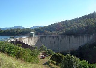
The Moogerah Dam is a mass concrete double curvature arch dam with an un-gated spillway across Reynolds Creek in South East Queensland, Australia, now within the locality of Moogerah in the Scenic Rim Region. The main purposes of the dam are for irrigation in the Reynolds Creek district and for supply of potable water to Warrill Creek and farmers in the Warrill Valley. The impounded reservoir is called Lake Moogerah.

The Burdekin Falls Dam, also known as the Burdekin Dam, is a concrete gravity dam with an uncontrolled spillway across the Burdekin River in the Whitsunday Region, Queensland, Australia. Built for the purpose of irrigation, the reservoir is called Lake Dalrymple, and is on the boundary of the Whitsunday Region and the Charters Towers Region. Burdekin Falls Dam is managed by SunWater. Water from the reservoir is also used to replenish downstream aquifers.
The Ross River Dam is a rock and earthfill-filled embankment dam across the Ross River, located between Kelso and Mount Stuart in the City of Townsville in northern Queensland, Australia. Built initially for flood control, Lake Ross, the impoundment created by the dam, serves as one of the major potable water supplies for the region.

Leslie Dam is a dam in the locality of the same name Leslie Dam, Southern Downs Region, Queensland, Australia. It impounds Sandy Creek, a tributary of the Condamine River, to create Lake Leslie. It is 11 kilometres (6.8 mi) from Warwick town centre. It was built for water storage and not for flood mitigation. Freshwater fishing and water sports facilities are available.

The Borumba Dam is a rock-fill embankment dam with an un-gated spillway located across the Yabba Creek, a tributary of the Mary River, in the Wide Bay–Burnett region of Queensland, Australia. The main purposes of the dam are for irrigation and potable water supply. The resultant impounded reservoir is called Lake Borumba.
The Fred Haigh Dam is a dam in the Bundaberg Region, Queensland, Australia. It was constructed across the Kolan River in 1978 creating Lake Monduran. The dam's catchment area, north of Bundaberg in Queensland, covers 1308 km2. It is named after Frederick Haigh who was Queensland's Commissioner of Irrigation and Water Supply from 1955 to 1974. The Monduran Dam, under construction at the time of his death, was named after him upon completion.

The Bjelke-Petersen Dam is a dam in Moffatdale near Cherbourg in the South Burnett Region, Queensland, Australia. The dam impounds Barker Creek and creates Lake Barambah. It is named after the Queensland Premier Joh Bjelke-Petersen. It is operated by Sunwater.

Boondooma Dam is a dam on the Boyne River on the boundary of Boondooma and Proston in the South Burnett Region of Queensland, Australia. From 1980 to 1983, the dam was constructed across the Boyne River below its confluence with the Stuart River, creating Lake Boondooma.
Wuruma Dam was constructed across the Nogo River in the upper Burnett River Catchment 48km north-west of Eidsvold for irrigation & town water supply for Eidsvold, Mundubbera and Gayndah. The dam wall is of mass concrete gravity construction which cost $5.3m to build and was completed in 1968. It has a surface area when full of 1,639 hectares, and a capacity of 165,400 ML. The dam takes its name from a local indigenous word meaning brahminy kite.

The Bill Gunn Dam is an earth-fill embankment dam with an un-gated spillway located off-stream in Laidley Heights in the South East region of Queensland, Australia. The main purpose of the dam is for irrigation of the Lockyer Valley. The resultant reservoir is called Lake Dyer.

Lake Julius was formed following the construction of Julius Dam in 1976 for irrigation and town water storage. The dam wall is located just below the junction of the Leichhardt River and Paroo Creek some 70 km (43 mi) North East of Mount Isa. With a catchment area of 4,845 km2 (1,871 sq mi) it has a full supply capacity, at a supply level of 223.54m AHD, of 107,500 ML, a surface area of 1,255 ha with an average depth of 8.9 m (29 ft).

The Splityard Creek Dam is a rock and earth-fill embankment dam with an un-gated spillway across the Pryde Creek that is located in the South East region of Queensland, Australia. The sole purpose of the dam is for the generation of hydroelectricity. The impounded reservoir is called the Splityard Creek Reservoir.
The Callide Dam is an earth and rock-fill dam which was constructed in 1965 to supply water for the Callide Power Station in Mount Murchison near Biloela in the state of Queensland, Australia. The impoundment of the dam is Lake Callide, which holds 136,370 megalitres (3.603×10¹⁰ US gal) at an average depth of 10.5 metres (34 ft) and a surface area of 1,240 hectares (3,100 acres) at full capacity.

The Six Mile Creek Dam is a rock and earth-fill embankment dam with an un-gated spillway across the Six Mile Creek that is located in the South East region of Queensland, Australia. The main purposes of the dam are for potable water supply of the Sunshine Coast region and for recreation. The impounded reservoir is called Lake Macdonald, named in memory of former Noosa Shire Council Chairman Ian MacDonald.
Kidston Dam also known as Copperfield Dam is a dam in Lyndhurst, Shire of Etheridge, Queensland, Australia. It is approximately 200 kilometres (120 mi) north of Hughenden and was built for the Kidston Gold Mine. The mine closed July 2001. The lake created by the dam has a capacity of 20,600 megalitres.

