Scottville, Queensland

Last updated

Scottville
Queensland
Australia Queensland location map.svg
Red pog.svg
Scottville
Coordinates 20°34′S147°49′E / 20.567°S 147.817°E / -20.567; 147.817 Coordinates: 20°34′S147°49′E / 20.567°S 147.817°E / -20.567; 147.817
Population344 (2011 census) [1]
Postcode(s) 4804
Location
LGA(s) Whitsunday Region
State electorate(s) Burdekin
Federal Division(s) Capricornia
Localities around Scottville:
Collinsville Collinsville Collinsville
Springlands Scottville Springlands
Springlands Springlands Springlands

Scottville is a small town and locality in the Whitsunday Region, Queensland, Australia. [2] [3] In the 2011 census, Scottvile had a population of 344 people. [1]

Suburbs and localities are the names of geographic subdivisions in Australia, used mainly for address purposes. The term locality is used in rural areas, while the term suburb is used in urban areas. Australian postcodes closely align with the boundaries of localities and suburbs.

Whitsunday Region Local government area in Queensland, Australia

The Whitsunday Region is a local government area located in North Queensland, Australia. Established in 2008, it was preceded by two previous local government areas with a history extending back to the establishment of regional local government in Queensland in 1879.

Queensland North-east state of Australia

Queensland is the second-largest and third-most populous state in the Commonwealth of Australia. Situated in the north-east of the country, it is bordered by the Northern Territory, South Australia and New South Wales to the west, south-west and south respectively. To the east, Queensland is bordered by the Coral Sea and Pacific Ocean. To its north is the Torres Strait, with Papua New Guinea located less than 200 km across it from the mainland. The state is the world's sixth-largest sub-national entity, with an area of 1,852,642 square kilometres (715,309 sq mi).

Contents

Geography

Scottville is in the Bowen Basin coal-mining area. It is located 4 kilometres (2.5 mi) south of the larger town of Collinsville. Scottville is located in the Whitsunday local government area, the administrative headquarters of which are located in Proserpine, 89 kilometres (55 mi) to the east.

Bowen Basin foreland sedimentary province in Australia

The Bowen Basin contains the largest coal reserves in Australia. This major coal-producing region contains one of the world's largest deposits of bituminous coal. The Basin contains much of the known Permian coal resources in Queensland including virtually all of the known mineable prime coking coal. It was named for the Bowen River, itself named after Queensland's first Governor, Sir George Bowen.

Collinsville, Queensland Town in Queensland, Australia

Collinsville is a town and locality in the Whitsunday Region, Queensland, Australia. In the 2011 census, Collinsville had a population of 1,501 people.

Proserpine, Queensland Town in Queensland, Australia

Proserpine is a town and a locality in the Whitsunday Region, Queensland, Australia. Founded in the 1890s, it is the administrative/service centre and gateway to the Whitsunday Region by road, rail and air. At the 2016 census, Proserpine had a population of 3,562. Proserpine is expected to grow rapidly due to its ample land for development, investment in infrastructure and its affordability for first home buyers and families. It is also planned to become an export hub for produce from the northern region which will further boost employment. The town has seen significant public and private investment in recent years and is a popular area for new residents to the region with ex residents of places like Sydney finding Proserpine an attractive town to migrate to, the town currently holds the top ranking for suburbs in the Mackay/Whitsunday region on Homely.com.au when ranked by infrastructure, education, sporting facilities. It is also popular among golfers with the only 18 hole course on the mainland.

History

Bowen Consolidated Coal Mines Limited developed its own company township 4 km south of Collinsville. It was originally to be named Scottdale (or possibly Scotsdale) after two of the directors, Adam Hall Scott and John Dinsdale, but the name was changed to Scottville after objections from the postal authorities. [2] [4]

Scottdale Provisional School opened on 28 January 1924 under headteacher Albert Czislowski operating from temporary premises with an iron roof and bag sides. [5] By June 1924, there were 35 students enrolled. [6] [7] In August 1924, the Queensland Government announced it would construct a permanent school building at a cost of £744. [8] The school was renamed Scottville Provisional School in September 1924 and then proclaimed as Scottville State School on 27 February 1925. [9] [10]

The Scottville sports ground opened on Tuesday 3 June 1924, with people travelling by bus from Collinsville to participate in the opening sports events including kicking and throwing balls, wood chopping, wheelbarrow racing, ladies nail driving, and 5-a-side soccer. [6]

Woodchopping sport

Woodchopping, called woodchop for short, is a sport that has been around for hundreds of years in several cultures. In woodchopping competitions, skilled contestants attempt to be the first to cut or saw through a log or other block of wood. It is often held at state fairs and agricultural shows. Participants are often referred to as axemen.

Heritage listings

Scottville has a number of heritage-listed sites, including:

Education

The Scottville State School is a government co-educational primary (P-6) school in Eleventh Avenue. In 2014, it had an enrolment of 59 students with 4 teachers. [11] The nearest secondary school is in neighbouring Collinsville. [12]

Related Research Articles

Bowen, Queensland Town in Queensland, Australia

Bowen is a coastal town and locality in the Whitsunday Region on the eastern coast of Queensland, Australia. The town of Merinda and the Abbot Point coal shipping port are also within the locality of Bowen. At the 2016 census, Bowen had a population of 10,377.

Mackay, Queensland City in Queensland, Australia

Mackay is a city and its centre suburb in the Mackay Region on the eastern coast of Queensland, Australia. It is located about 970 kilometres (603 mi) north of Brisbane, on the Pioneer River. Mackay is nicknamed the sugar capital of Australia because its region produces more than a third of Australia's sugar.

Baralaba, Queensland Town in Queensland, Australia

Baralaba is a small town and rural locality in the Shire of Banana in central Queensland, Australia. In the 2016 census, Baralaba had a population of 314 people.

Rosewood, Queensland Town in Queensland, Australia

Rosewood is a small town and locality in the Bremer Valley, Queensland, Australia. It is within the local government area of City of Ipswich.

Shire of Bowen Local government area in Queensland, Australia

The Shire of Bowen was a local government area in the North Queensland region of Queensland, Australia. The shire, administered from the town of Bowen, covered an area of 21,184.4 square kilometres (8,179.3 sq mi), and existed as a local government entity from 1879 until 2008, when it amalgamated with the Shire of Whitsunday to form the Whitsunday Region.

Gumlu, Queensland Town in Queensland, Australia

Gumlu is a town and coastal locality in the Whitsunday Region, Queensland, Australia.

The Collinsville Coal Mine is a coal mine located near Collinsville in Central Queensland, Australia. The open-cut mine lies in the northern Bowen Basin. Collinsville produces coking and steaming coal for both domestic use and export. Exports leave the country via Abbot Point.

Mount Coolon, Queensland Suburb of Whitsunday Region, Queensland, Australia

Mount Coolon is a small town and locality in the Whitsunday Region, Queensland, Australia. In the 2011 census, Mount Coolon had a population of 567 people.

Springlands, Queensland Suburb of Whitsunday Region, Queensland, Australia

Springlands is a rural locality in the Whitsunday Region, Queensland, Australia. In the 2016 census, Springlands had a population of 45 people.

Kabra, Queensland Suburb of Rockhampton Region, Queensland, Australia

Kabra is a town and rural locality in the Rockhampton Region, Queensland, Australia. In the 2011 census, Kabra had a population of 472 people.

Bowen River (Queensland) river

The Bowen River is a river located in North Queensland, Australia.

Bowen Consolidated Colliery

Bowen Consolidated Colliery is a heritage-listed former mine at Station Street and Second Avenue, Scottville, Whitsunday Region, Queensland, Australia. It was established in 1919. It is also known as No. 1 Underground Mine and Bowen Consolidated Coal Company Colliery. It was added to the Queensland Heritage Register on 3 December 2009.

Collinsville Cemetery, Queensland heritage-listed cemetery in Australia

Collinsville Cemetery is a heritage-listed cemetery at Collinsville-Scottville Road, Collinsville, Whitsunday Region, Queensland, Australia. It was built from 1927 onwards. It is also known as Collinsville-Scottville Cemetery. It was added to the Queensland Heritage Register on 18 September 2009.

The Collinsville mine disaster on 13 October 1954 resulted in the death of seven men at the Collinsville coal mine in Collinsville, Queensland, Australia.

Henry Daniel Sinclair (1818–1868) was an explorer and founder of Bowen, Queensland, Australia. Captain Sinclair discovered Port Denison in 1859 in the cutter Santa Barbara.

Bowen Basin Coalfields Coal mine with gas fields in Australia

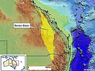
The Bowen Basin Coalfields contains the largest coal reserves in Australia. This major coal-producing region contains one of the world's largest deposits of bituminous coal. The Basin contains much of the known Permian coal resources in Queensland including virtually all of the known mineable prime coking coal. It was named for the Bowen River, itself named after Queensland's first Governor, Sir George Bowen.

References

  1. 1 2 Australian Bureau of Statistics (31 October 2012). "Scottville". 2011 Census QuickStats. Retrieved 10 January 2016. OOjs UI icon edit-ltr-progressive.svg
  2. 1 2 "Scottville - town (entry 30154)". Queensland Place Names. Queensland Government . Retrieved 10 January 2016.
  3. "Scottville - locality (entry 46897)". Queensland Place Names. Queensland Government . Retrieved 10 January 2016.
  4. 1 2 "Bowen Consolidated Colliery (entry 601850)". Queensland Heritage Register . Queensland Heritage Council. Retrieved 16 July 2013.
  5. "Opening and closing dates of Queensland Schools". Queensland Government . Retrieved 10 January 2016.
  6. 1 2 "COLLINSVILLE NOTES". Bowen Independent . Qld. 14 June 1924. p. 3. Retrieved 11 January 2016 via National Library of Australia.
  7. "WITH THE MINISTERIAL PARTY AT COLLINSVILLE". Bowen Independent . Qld. 5 July 1924. p. 7. Retrieved 11 January 2016 via National Library of Australia.
  8. "NEW STATE SCHOOLS". The Brisbane Courier . 23 August 1924. p. 16. Retrieved 11 January 2016 via National Library of Australia.
  9. "Agency ID5685, Scottville State School". Queensland State Archives . Retrieved 11 January 2015.
  10. Queensland Family History Society (2010), Queensland schools past and present (Version 1.01 ed.), Queensland Family History Society, ISBN   978-1-921171-26-0
  11. "2014 School Annual Report" (PDF). Scottville State School. Retrieved 11 January 2016.
  12. "Queensland State and Non-State Schools". Queensland Government. 24 February 2014. Retrieved 10 January 2016.