Cannonvale, Queensland

Last updated

Cannonvale
Queensland
Cannonvale beach, 2012.jpg
Cannonvale beach, 2012
Australia Queensland location map.svg
Red pog.svg
Cannonvale
Coordinates 20°17′11″S148°41′12″E / 20.2863°S 148.6866°E / -20.2863; 148.6866 (Cannonvale (centre of locality))
Population6,596 (2021 census) [1]
 • Density795/km2 (2,058/sq mi)
Postcode(s) 4802
Area8.3 km2 (3.2 sq mi)
Time zone AEST (UTC+10:00)
Location
LGA(s) Whitsunday Region
State electorate(s) Whitsunday
Federal division(s) Dawson
Suburbs around Cannonvale:
Coral Sea Coral Sea Airlie Beach
Woodwark Cannonvale Cape Conway
Cannon Valley Cannon Valley Cape Conway

Cannonvale is a coastal locality in the Whitsunday Region, Queensland, Australia. [2] In the 2021 census, Cannonvale had a population of 6,596 people. [1]

Contents

Geography

Pigeon Island in Pioneer Bay, 2007 Looking from Coral Esplanade, Cannonvale, across Pioneer Bay to Pigeon Island, 2007.jpg
Pigeon Island in Pioneer Bay, 2007

Pioneer Bay (part of the Coral Sea, 20°14′46″S148°42′40″E / 20.246°S 148.711°E / -20.246; 148.711 (Pioneer Bay) ) forms the northern boundary of the locality. [3] [4] [5] Pigeon Island is a 1.8-hectare (4.4-acre) marine island ( 20°15′57″S148°41′45″E / 20.2658°S 148.6958°E / -20.2658; 148.6958 (Pigeon Island) ) within Pioneer Bay. It is a roosting area for the Nutmeg pigeon which migrate south to the Whitsundays in large numbers in the summer months each year. [6]

Shingley Beach ( 20°16′11″S148°42′33″E / 20.2697°S 148.7092°E / -20.2697; 148.7092 (Shingley Beach) ) is a sandy strip on the far north-eastern coast of the locality extending into neighbouring locality of Airlie Beach. [7] [4]

Scrubby Hill ( 20°16′22″S148°41′35″E / 20.2728°S 148.6931°E / -20.2728; 148.6931 (Scrubby Hill) ) is 91 metres (299 ft) high and on the northern coast of the locality. [8] [9] [4]

The Proserpine-Shute Harbour Road (State Route 59) runs through from south-west to north-east. [4]

History

The locality was originally named Cannon Valley in 1866 by George Strong Nares, commander of HMS Salamander, after Richard Cannon, the Assistant Surgeon on the ship. Town allotments near the beach on Pioneer Bay were sold by public auction in 1904 under the name Cannonvale. However, the local people preferred to call it Cannon Valley Beach. In 1930, the post office name was changed to Deauville but in 1947 was renamed Cannonvale Beach. [10] It is now simply Cannonvale, while the name Cannon Valley is retained by the inland area. [2]

Cannon Valley State School and Cannonvale State School Cannon Valley State School and Cannonvale State School.jpg
Cannon Valley State School and Cannonvale State School

Cannon Vale Provisional School opened on 8 February 1892. It closed in 1908, but then reopened on a new site on the north-eastern corner of Shute Harbour Road and Abell Road ( 20°17′20″S148°40′42″E / 20.2890°S 148.6784°E / -20.2890; 148.6784 (Cannon Valley State School (former)) ) as Cannon Valley State School on 23 April 1910 to service the local farming community. [11] [12] [13] In 1968, it was decided to relocate the school back into Cannonvale as the majority of the students were coming from Cannonvale. The new school buildings in Cannonvale opened in July 1969 with 84 students and the school was then renamed Cannonvale State School. [14] [15] Due to suburban growth in Cannonvale, the 1910 site is now within the boundaries of Cannonvale rather than Cannon Valley. [4]

Sponsored by the Whitsunday Baptist Church, Whitsunday Christian College opened in January 1997 with approximately 30 students. It operated from a number of sites before establishing its current Paluma Drive campus which officially opened on 29 November 2002. [16] [15]

On 31 January 1987, the town of Cannonvale was discontinued as the locality was amalgamated into the new larger town of Whitsunday. [17]

The Cannonvale public library opened in 2006. [18]

Stricken yacht washed onto the beach at Cannonvale during Cyclone Anthony, 1 February 2010 Rumrunner on the Beach, Stricken yacht washed onto the beach at Cannonvale, 1 February 2010.jpg
Stricken yacht washed onto the beach at Cannonvale during Cyclone Anthony, 1 February 2010

In January-February 2010, storm surges caused by Cyclone Anthony battered the coastline. [19] [20]

Demographics

In the 2016 census Cannonvale had a population of 5,716 people. [21]

In the 2021 census, Cannonvale had a population of 6,596 people. [1]

Education

Cannonvale State School is a government primary (Prep-6) school for boys and girls at 56 Coral Esplanade ( 20°16′29″S148°41′59″E / 20.2747°S 148.6996°E / -20.2747; 148.6996 (Cannonvale State School) ). [22] [23] In 2018, the school had an enrolment of 765 students with 55 teachers (53 full-time equivalent) and 28 non-teaching staff (22 full-time equivalent). [24] It includes a special education program. [22]

Whitsunday Christian College is a private primary and secondary (Prep-12) school for boys and girls at 26 Paluma Road ( 20°17′20″S148°40′29″E / 20.2889°S 148.6747°E / -20.2889; 148.6747 (Whitsunday Christian College) ). [22] [25] In 2018, the school had an enrolment of 282 students with 22 teachers (20 full-time equivalent) and 15 non-teaching staff (13 full-time equivalent). [24]

There is no government secondary school in Cannonvale. The nearest government secondary school is Proserpine State High School in Proserpine to the south-west. [4]

TAFE Queensland has its Whitsunday campus at 190 Shute Harbour Road ( 20°16′43″S148°41′50″E / 20.2786°S 148.6971°E / -20.2786; 148.6971 (TAFE Whitsunday campus) ). [26] It provides technical and vocational education in the areas of hospitality, cookery, early childhood education, and child care. [27]

Facilities

Damaged boat near Volunteer Marine Rescue Whitsunday, 2011 Damaged boat near Volunteer Marine Rescue Whitsunday in Cannonvale.jpg
Damaged boat near Volunteer Marine Rescue Whitsunday, 2011

Whitsunday Police Station is at 8 Altmann Avenue ( 20°16′21″S148°42′17″E / 20.2726°S 148.7046°E / -20.2726; 148.7046 (Whitsunday Police Station) ). [28] [29]

Cannonvale SES Facility is at 22 Schnapper Street ( 20°16′35″S148°41′56″E / 20.2765°S 148.6988°E / -20.2765; 148.6988 (Cannonvale SES Facility) ). [28]

Whitsunday Community Health is at 12 Altmann Street ( 20°16′19″S148°42′20″E / 20.2720°S 148.7055°E / -20.2720; 148.7055 (Whitsunday Community Health centre) ). [26] [30]

Whitsunday Ambulance Station is at 7 Schnapper Street ( 20°16′33″S148°41′52″E / 20.2757°S 148.6979°E / -20.2757; 148.6979 (Whitsunday Ambulance Station) ). [28]

The Volunteer Marine Rescue Whitsunday (VMR 442) [31] are based at 7 Altmann Avenue ( 20°16′16″S148°42′13″E / 20.2710°S 148.7036°E / -20.2710; 148.7036 (Volunteer Marine Rescue Whitsunday) ). They protect the area from Gloucester Island to the north to Cape Conway and Shaw Island to the south. [32] They use the adjacent Whisper Bay boat ramp. [33]

Amenities

The Whitsunday Regional Council operates a public library in the Whitsunday Plaza Shopping Centre, 8 Galbraith Park Drive ( 20°17′24″S148°40′34″E / 20.2899°S 148.6762°E / -20.2899; 148.6762 (Cannonvale public library) ). [34]

St Martin's Church is at 4 St Martins Road ( 20°16′29″S148°42′16″E / 20.2747°S 148.7044°E / -20.2747; 148.7044 (St Martin's Church) ). It is jointly owned by the Catholic and Lutheran churches, but is also used for Baptist, Anglican and Uniting Church services. [35] [36] [37] [38] [39] [40]

Abell Point Marina is a boat ramp at off Shingley Drive at Shingley Beach ( 20°16′11″S148°42′29″E / 20.2696°S 148.7080°E / -20.2696; 148.7080 (Abell Point Marina boat ramp) ); it is managed by the Whitsunday Regional Council. [33]

Whisper Bay boat ramp and floating walkway is at Altmann Avenue ( 20°16′15″S148°42′14″E / 20.2708°S 148.7039°E / -20.2708; 148.7039 (Whisper Bay boat ramp) ); it is managed by the Whitsunday Regional Council. [33]

Related Research Articles

<span class="mw-page-title-main">Bowen, Queensland</span> Town in Queensland, Australia

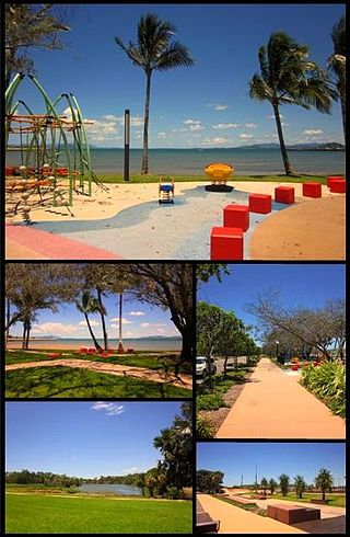
Bowen is a coastal town and locality in the Whitsunday Region, Queensland, Australia. In the 2016 census, the locality of Bowen had a population of 10,377 people.

<span class="mw-page-title-main">Airlie Beach, Queensland</span> Suburb of Whitsunday Region, Queensland, Australia

Airlie Beach is a coastal locality and resort town in the Whitsunday Region of Queensland, Australia. In the 2021 census, Airlie Beach had a population of 1,312 people.

<span class="mw-page-title-main">Shute Harbour</span> Suburb of Whitsunday Region, Queensland, Australia

Shute Harbour is a coastal locality and harbour in the Whitsunday Region of Queensland, Australia. It has port facilities and transport options for people seeking to access the Whitsunday Islands and holiday destinations.

<span class="mw-page-title-main">Whitsunday Region</span> Local government area in Queensland, Australia

The Whitsunday Region is a local government area located in North Queensland, Australia. Established in 2008, it was preceded by two previous local government areas with a history extending back to the establishment of regional local government in Queensland in 1879.

<span class="mw-page-title-main">Midge Point, Queensland</span> Town in Queensland, Australia

Midge Point is a coastal town and rural locality in the Mackay Region, Queensland, Australia. In the 2016 census, the locality of Midge Point had a population of 464 people.

Laguna Quays is a coastal locality in the Mackay Region, Queensland, Australia. In the 2021 census, Laguna Quays had a population of 89 people.

Mount Marlow is a rural locality in the Whitsunday Region, Queensland, Australia. In the 2021 census, Mount Marlow had a population of 161 people.

Conway is a locality in the Whitsunday Region, Queensland, Australia. In the 2021 census, Conway had a population of 202 people.

<span class="mw-page-title-main">Cape Conway, Queensland</span> Suburb of Whitsunday Region, Queensland, Australia

Cape Conway is a coastal locality in the Whitsunday Region, Queensland, Australia. In the 2021 census, Cape Conway had "no people or a very low population".

Gunyarra is a rural locality in the Whitsunday Region, Queensland, Australia. In the 2021 census, Gunyarra had a population of 30 people.

<span class="mw-page-title-main">Flametree, Queensland</span> Suburb of Whitsunday Region, Queensland, Australia

Flametree is a coastal locality in the Whitsunday Region, Queensland, Australia. In the 2021 census, Flametree had a population of 143 people.

Mandalay is a coastal locality in the Whitsunday Region, Queensland, Australia. In the 2021 census, Mandalay had a population of 338 people.

<span class="mw-page-title-main">Jubilee Pocket, Queensland</span> Suburb of Whitsunday Region, Queensland, Australia

Jubilee Pocket is a residential locality in the Whitsunday Region, Queensland, Australia. In the 2021 census, Jubilee Pocket had a population of 2,047 people.

<span class="mw-page-title-main">Cannon Valley, Queensland</span> Suburb of Whitsunday Region, Queensland, Australia

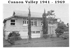
Cannon Valley is a semi-rural locality in the Whitsunday Region, Queensland, Australia. In the 2021 census, Cannon Valley had a population of 1,131 people.

Woodwark is a coastal locality in the Whitsunday Region, Queensland, Australia. In the 2021 census, Woodwark had a population of 559 people.

<span class="mw-page-title-main">Cape Gloucester, Queensland</span> Suburb of Whitsunday Region, Queensland, Australia

Cape Gloucester is a coastal locality in the Whitsunday Region, Queensland, Australia. In the 2021 census, Cape Gloucester had a population of 85 people.

<span class="mw-page-title-main">Dingo Beach, Queensland</span> Suburb of Whitsunday Region, Queensland, Australia

Dingo Beach is a coastal rural locality in the Whitsunday Region, Queensland, Australia. In the 2021 census, Dingo Beach had a population of 159 people.

<span class="mw-page-title-main">Hideaway Bay, Queensland</span> Town in Queensland, Australia

Hideaway Bay, also spelled Hydeaway Bay, is a coastal town and locality in the Whitsunday Region, Queensland, Australia. In the 2021 census, the locality of Hideaway Bay had a population of 232 people.

Preston is a rural locality in the Whitsunday Region, Queensland, Australia. In the 2021 census, Preston had a population of 346 people.

Proserpine–Shute Harbour Road is a continuous 34.3 kilometres (21.3 mi) road route in the Whitsunday local government area of Queensland, Australia. The route is designated as State Route 59. It is a state-controlled regional road.

References

  1. 1 2 3 Australian Bureau of Statistics (28 June 2022). "Cannonvale (SAL)". 2021 Census QuickStats. Retrieved 28 February 2023. OOjs UI icon edit-ltr-progressive.svg
  2. 1 2 "Cannonvale – locality in Whitsunday Region (entry 49530)". Queensland Place Names. Queensland Government . Retrieved 21 July 2021.
  3. Google (20 August 2021). "Cannonvale, Queensland" (Map). Google Maps . Google. Retrieved 20 August 2021.
  4. 1 2 3 4 5 6 "Queensland Globe". State of Queensland . Retrieved 28 August 2023.
  5. "Bays - Queensland". Queensland Open Data. Queensland Government. 12 November 2020. Archived from the original on 25 November 2020. Retrieved 25 November 2020.
  6. "Pigeon Island – island in Whitsunday Regional (entry 26701)". Queensland Place Names. Queensland Government . Retrieved 21 July 2021.
  7. "Mountain ranges beaches and sea passages - Queensland". Queensland Open Data. Queensland Government. 12 November 2020. Archived from the original on 25 November 2020. Retrieved 25 November 2020.
  8. "Mountain peaks and capes - Queensland". Queensland Open Data. Queensland Government. 12 November 2020. Archived from the original on 25 November 2020. Retrieved 25 November 2020.
  9. "Scrubby Hill – mountain in Whitsunday Region (entry 30287)". Queensland Place Names. Queensland Government . Retrieved 25 November 2020.
  10. "CANNONVALE BEACH POST OFFICE". The Proserpine Guardian . Vol. 42, no. 2879. Queensland, Australia. 5 December 1947. p. 2. Archived from the original on 29 August 2021. Retrieved 11 November 2018 via National Library of Australia.
  11. "History". Cannonvale State School. 18 November 2019. Archived from the original on 4 March 2021. Retrieved 31 August 2021.
  12. "Proserpine Points". The Evening Telegraph . Vol. 8, no. 2341. Queensland, Australia. 17 December 1908. p. 5. Archived from the original on 31 August 2021. Retrieved 31 August 2021 via National Library of Australia.
  13. "8657-III-North Cannon Valley" (Map). Queensland Government. 1968. Archived from the original on 31 August 2021. Retrieved 31 August 2021.
  14. "History". Cannonvale State School. Archived from the original on 10 November 2018. Retrieved 10 November 2018.
  15. 1 2 Queensland Family History Society (2010), Queensland schools past and present (Version 1.01 ed.), Queensland Family History Society, ISBN   978-1-921171-26-0
  16. "OUR COLLEGE". WCC. Archived from the original on 8 March 2021. Retrieved 31 August 2021.
  17. "Whitsunday – town in Whitsunday Region (entry 37374)". Queensland Place Names. Queensland Government . Retrieved 26 October 2019.
  18. "Queensland Public Library Statistical Bulletin 2016-17" (PDF). Public Libraries Connect. November 2016. Archived (PDF) from the original on 2 March 2017. Retrieved 3 February 2018.
  19. "North Queensland 'dodges a bullet'". ABC News . 30 January 2011. Archived from the original on 16 April 2018. Retrieved 31 August 2021.
  20. "No forced evacuations". The Courier-Mail . 1 February 2011. Archived from the original on 31 August 2021. Retrieved 31 August 2021.
  21. Australian Bureau of Statistics (27 June 2017). "Cannonvale (SSC)". 2016 Census QuickStats. Retrieved 20 October 2018. OOjs UI icon edit-ltr-progressive.svg
  22. 1 2 3 "State and non-state school details". Queensland Government. 9 July 2018. Archived from the original on 21 November 2018. Retrieved 21 November 2018.
  23. "Cannonvale State School". Cannonvale State School. 24 August 2022. Retrieved 5 January 2024.
  24. 1 2 "ACARA School Profile 2018". Australian Curriculum, Assessment and Reporting Authority. Archived from the original on 27 August 2020. Retrieved 28 January 2020.
  25. "Whitsunday Christian College". Archived from the original on 27 November 2018. Retrieved 21 November 2018.
  26. 1 2 "Landmark Areas - Queensland". Queensland Open Data. Queensland Government. 18 November 2020. Archived from the original on 21 November 2020. Retrieved 21 October 2020.
  27. "Whitsundays TAFE Campus: Courses & Details | TAFE Queensland". TAFE Queensland . Archived from the original on 25 February 2021. Retrieved 31 August 2021.
  28. 1 2 3 "Emergency services facilities - Queensland". Queensland Open Data. Queensland Government. 18 November 2020. Archived from the original on 24 November 2020. Retrieved 24 November 2020.
  29. "Whitsunday Police Station". Queensland Police . Archived from the original on 4 April 2021. Retrieved 30 August 2021.
  30. "Whitsunday Community Health". Mackay Hospital and Health Services. Archived from the original on 30 April 2021. Retrieved 30 August 2021.
  31. "Marine Rescue QLD Locations". July 2023.
  32. "Volunteer Marine Rescue Whitsundays". VMR Whitsundays. Archived from the original on 17 April 2021. Retrieved 30 August 2021.
  33. 1 2 3 "Recreational Boating Facilities Queensland". Queensland Open Data. Queensland Government. 12 November 2020. Archived from the original on 22 November 2020. Retrieved 22 November 2020.
  34. "Cannonvale library". State Library of Queensland. Archived from the original on 11 January 2018. Retrieved 11 January 2018.
  35. Google (30 August 2021). "St Martin's Church" (Map). Google Maps . Google. Retrieved 30 August 2021.
  36. "Visitor to our Church". Proserpine Whitsunday Uniting Church. Archived from the original on 8 March 2021. Retrieved 29 August 2021.
  37. "Whitsunday Baptist Church". Archived from the original on 17 March 2021. Retrieved 29 August 2021.
  38. "Whitsunday Parish". Roman Catholic Diocese of Townsville . Archived from the original on 13 March 2021. Retrieved 29 August 2021.
  39. "Lutheran Church Cannonvale St Martins Congregation, Qld". Cannonvale St Martins Congregation, Qld. Archived from the original on 29 August 2021. Retrieved 29 August 2021.
  40. "Find a Church". Uniting Church in Australia, Queensland Synod. Archived from the original on 24 October 2020. Retrieved 22 November 2020.