Mount Rooper, Queensland

Last updated

Mount Rooper
Queensland
Long Island from Mount Rooper Lookout, 2008.jpg
Looking across the Conway National Park towards Long Island from the Mount Rooper Lookout, 2008
Australia Queensland location map.svg
Red pog.svg
Mount Rooper
Coordinates 20°16′16″S148°46′04″E / 20.2711°S 148.7677°E / -20.2711; 148.7677 Coordinates: 20°16′16″S148°46′04″E / 20.2711°S 148.7677°E / -20.2711; 148.7677
Population0 (2016 census) [1]
 • Density0.00/km2 (0.00/sq mi)
Postcode(s) 4802
Area15.8 km2 (6.1 sq mi)
Location
LGA(s) Whitsunday Region
State electorate(s) Whitsunday
Federal Division(s) Dawson
Suburbs around Mount Rooper:
Coral Sea Coral Sea Coral Sea
Flametree Mount Rooper Coral Sea
Cape Conway Coral Sea Shute Harbour

Mount Rooper is a coastal locality in the Whitsunday Region, Queensland, Australia. [2] In the 2016 census, Mount Rooper had no population. [1]

Contents

Geography

Mount Rooper is a mountainous headland with three main peaks which are (from north to south) Notch Hill, Mount Merkara, and Mount Rooper (221 metres). Notch Hill is 347 metres (1,138 ft) high and was named in May 1881 by Captain John Fiot Lee Pearse Maclear (Royal Navy) of HMS Alert because, when viewed from the east, the peak appears to have a notch. [3] Mount Merkara is 373 metres (1,224 ft) and was also named by Maclear in May 1881 after the RMS Merkara which they met on its first voyage as part of the Queensland Royal Mail Line between Australia and London. [4] The mountain Mount Rooper is 221 metres (725 ft) and named in 1932 by Lieutenant Commander C.G. Little (Royal Australian Navy) during a survey. Little named the mountain after the Rooper Inlet which it overlooks to the south (near present-day Shute Harbour), which was in turn named by Maclear in May 1881 after Lieutenant Henry E. Rooper on HMS Alert. [5] [6] [7]

All of the locality is a protected area, mostly within Conway National Park except for the south-eastern area which is in Conway Conservation Park. [7]

Shute Harbour Road follows the south-western boundary of the locality providing access to Shute Harbour on the southern side of the headland.

History

Mount Rooper comprises part of the former locality of Jubilee. [2]

Related Research Articles

Bowen, Queensland Town in Queensland, Australia

Bowen is a coastal town and locality in the Whitsunday Region on the eastern coast of Queensland, Australia. The locality is a large one, and contains two other towns, Heronvale and Merinda. The Abbot Point coal shipping port is also within the locality. At the 2016 census, Bowen had a population of 10,377.

Whitsunday Islands island group in Queensland, Australia

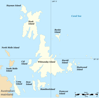
The Whitsunday Islands are a collection of 74 continental islands of various sizes off the central coast of Queensland, Australia, approximately 900 kilometres north of Brisbane. The northernmost of the islands are situated off the coast by the town of Bowen while the southernmost islands are off the coast by Proserpine. The island group is centred on Whitsunday Island, while the group's commercial centre is Hamilton Island. The traditional owners of the area are the Ngaro people and the Gia people whose Juru people has the only legally recognised native title in the region.

Shute Harbour Suburb of Whitsunday Region, Queensland, Australia

Shute Harbour is a coastal locality and harbour in the Whitsunday Region of Queensland, Australia. In the 2016 census, Shute Harbour had a population of 122 people.

Whitsunday Airport airport in Australia

Whitsunday Airport is an airport located in Flametree in the Whitsunday Region, Queensland, Australia. It is located between the popular tourist destinations of Airlie Beach, Shute Harbour and the Whitsunday Islands. Due to the mountainous terrain in the tourist area, there are limited opportunities for airports.

Mount Rascal, Queensland Suburb of Toowoomba Region, Queensland, Australia

Mount Rascal is a rural locality in the Toowoomba Region, Queensland, Australia. In the 2016 census, Mount Rascal had a population of 462 people.

Mount Irving, Queensland Suburb of Toowoomba Region, Queensland, Australia

Mount Irving is a rural locality in the Toowoomba Region, Queensland, Australia. In the 2016 census, Mount Irving had a population of 15 people.

Mount Walker West, Queensland Suburb of Scenic Rim Region, Queensland, Australia

Mount Walker West is a locality split between the Scenic Rim Region and City of Ipswich local government areas of Queensland, Australia. In the 2016 census, Mount Walker West had a population of 19 people.

Guthalungra, Queensland Town in Queensland, Australia

Guthalungra is a town and a coastal locality in the Whitsunday Region, Queensland, Australia.

Cape Conway, Queensland Suburb of Whitsunday Region, Queensland, Australia

Cape Conway is a coastal locality in the Whitsunday Region, Queensland, Australia. In the 2016 census, Cape Conway had no population.

Flametree, Queensland Suburb of Whitsunday Region, Queensland, Australia

Flametree is a coastal locality in the Whitsunday Region, Queensland, Australia. In the 2016 census, Flametree had a population of 122 people.

Mandalay, Queensland Suburb of Whitsunday Region, Queensland, Australia

Mandalay is a coastal locality in the Whitsunday Region, Queensland, Australia. In the 2016 census, Mandalay had a population of 337 people.

Jubilee Pocket, Queensland Suburb of Whitsunday Region, Queensland, Australia

Jubilee Pocket is a locality in the Whitsunday Region, Queensland, Australia. In the 2016 census, Jubilee Pocket had a population of 1817 people.

Albinia, Queensland Suburb of Central Highlands Region, Queensland, Australia

Albinia is a locality in the Central Highlands Region, Queensland, Australia. In the 2016 census, Albinia had a population of 112 people.

Leslie Dam, Queensland Suburb of Southern Downs Region, Queensland, Australia

Leslie Dam is a locality in the Southern Downs Region, Queensland, Australia. In the 2016 census, Leslie Dam had a population of 163 people.

Mount Mackay, Queensland Suburb of Cassowary Coast Region, Queensland, Australia

Mount Mackay is a locality in the Cassowary Coast Region, Queensland, Australia. In the 2016 census, Mount Mackay had a population of 0 people.

Wivenhoe Hill, Queensland Suburb of Somerset Region, Queensland, Australia

Wivenhoe Hill is a locality in the Somerset Region, Queensland, Australia. In the 2016 census, Wivenhoe Hill had a population of 9 people.

Boulder Creek, Queensland Suburb of Rockhampton Region, Queensland, Australia

Boulder Creek is a locality in the Rockhampton Region, Queensland, Australia. In the 2016 census, Boulder Creek had a population of 12 people.

Whitsunday, Queensland Town in Queensland, Australia

Whitsunday is a coastal town in the Whitsunday Region, Queensland, Australia.

Mount Moffatt, Queensland Suburb of Maranoa Region, Queensland, Australia

Mount Moffatt is a rural locality in the Maranoa Region, Queensland, Australia. In the 2016 census, Mount Moffatt had a population of 0 people.

References

  1. 1 2 Australian Bureau of Statistics (27 June 2017). "Mount Rooper (SSC)". 2016 Census QuickStats. Retrieved 20 October 2018. OOjs UI icon edit-ltr-progressive.svg
  2. 1 2 "Mount Rooper - locality in Whitsunday Region (entry 46888)". Queensland Place Names. Queensland Government . Retrieved 9 November 2018.
  3. "Notch Hill - hill in the Whitsunday Region (entry 24785)". Queensland Place Names. Queensland Government . Retrieved 9 November 2018.
  4. "Mount Merkara - mountain in the Whitsunday Region (entry 21645)". Queensland Place Names. Queensland Government . Retrieved 9 November 2018.
  5. "Mount Rooper - mountain in the Whitsunday Region (entry 29002)". Queensland Place Names. Queensland Government . Retrieved 9 November 2018.
  6. "Rooper Inlet - inlet in the Whitsunday Region (entry 29002)". Queensland Place Names. Queensland Government . Retrieved 9 November 2018.
  7. 1 2 "Queensland Globe". State of Queensland . Retrieved 8 November 2018.

Commons-logo.svg Media related to Mount Rooper, Queensland at Wikimedia Commons