
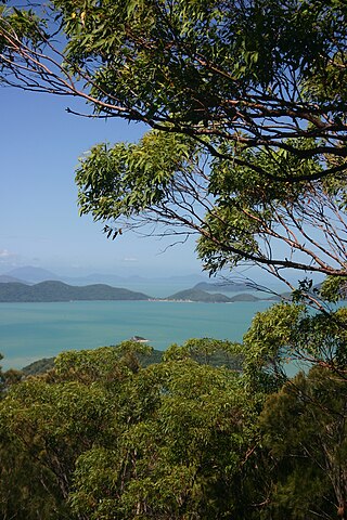
Shute Harbour is a coastal locality and harbour in the Whitsunday Region of Queensland, Australia. It has port facilities and transport options for people seeking to access the Whitsunday Islands and holiday destinations.

Springlands is a rural locality in the Whitsunday Region, Queensland, Australia.
Mount Wyatt is a mountain and rural locality in the Whitsunday Region, Queensland, Australia. In the 2021 census, Mount Wyatt had a population of 34 people.
Mount Marlow is a rural locality in the Whitsunday Region, Queensland, Australia. In the 2021 census, Mount Marlow had a population of 161 people.
Hamilton Plains is a rural locality in the Whitsunday Region, Queensland, Australia. In the 2021 census, Hamilton Plains had a population of 80 people.
Mount Rooper is a coastal locality in the Whitsunday Region, Queensland, Australia. In the 2021 census, Mount Rooper had "no people or a very low population".
Mandalay is a coastal locality in the Whitsunday Region, Queensland, Australia. In the 2021 census, Mandalay had a population of 338 people.
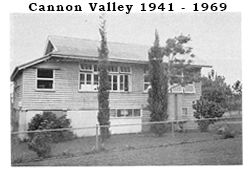
Cannon Valley is a semi-rural locality in the Whitsunday Region, Queensland, Australia. In the 2021 census, Cannon Valley had a population of 1,131 people.
Goorganga Plains is a coastal locality in the Whitsunday Region, Queensland, Australia. In the 2021 census, Goorganga Plains had "no people or a very low population".
Wilson Beach is a coastal locality in the Whitsunday Region, Queensland, Australia. In the 2021 census, Wilson Beach had a population of 68 people.
Woodwark is a coastal locality in the Whitsunday Region, Queensland, Australia. In the 2021 census, Woodwark had a population of 559 people.

Dingo Beach is a coastal rural locality in the Whitsunday Region, Queensland, Australia. In the 2021 census, Dingo Beach had a population of 159 people.

Hideaway Bay, also spelled Hydeaway Bay, is a coastal town and locality in the Whitsunday Region, Queensland, Australia. In the 2021 census, the locality of Hideaway Bay had a population of 232 people.
Lake Proserpine is a rural locality in the Whitsunday Region, Queensland, Australia. In the 2021 census, Lake Proserpine had a population of 6 people.
Mount Pluto is a rural locality in the Whitsunday Region, Queensland, Australia. In the 2021 census, Mount Pluto had "no people or a very low population".
Brandy Creek is a rural locality in the Whitsunday Region, Queensland, Australia. In the 2021 census, Brandy Creek had a population of 114 people.
Thoopara is a rural locality in the Whitsunday Region, Queensland, Australia. In the 2021 census, Thoopara had a population of 52 people.
Newlands is a rural locality in the Whitsunday Region, Queensland, Australia. In the 2021 census, Newlands had a population of 99 people.
Silver Creek is a rural locality in the Whitsunday Region, Queensland, Australia. In the 2021 census, Silver Creek had a population of 18 people.
Preston is a rural locality in the Whitsunday Region, Queensland, Australia. In the 2021 census, Preston had a population of 346 people.
