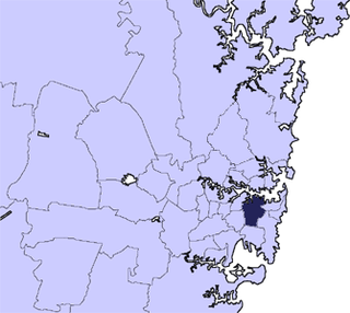
The City of Sydney is the local government area covering the Sydney central business district and surrounding inner city suburbs of the Greater Sydney, New South Wales, Australia. Established by Act of Parliament in 1842, the City of Sydney is the oldest, and the oldest-surviving, local government authority in New South Wales, and the second-oldest in Australia, with only the City of Adelaide being older by two years.
Holroyd is a small suburb in western Sydney, New South Wales, Australia. Holroyd is located 20 kilometres (12 mi) west of the Sydney central business district in the local government area of the Cumberland Council. The previous local government area of Holroyd City took its name from Arthur Holroyd, first Mayor of the area, local landowner and businessman. The administrative centre is located in nearby Merrylands.

The locality and suburb of Gymea Bay are located in southern Sydney, in the state of New South Wales, Australia. Gymea Bay is 27 kilometres (17 mi) south of the Sydney central business district, in the local government area of the Sutherland Shire. The postcode is 2227, which it shares with the adjacent suburb of Gymea. The Gymea Bay locality takes its name from the adjoining Gymea Bay, a small bay on the north side of the Port Hacking estuary).

Paratoo is a locality in the Australian state of South Australia located about 254 kilometres (158 mi) north-east of the state capital of Adelaide and about 52 kilometres (32 mi) north-east of the municipal seat in Peterborough.
Bucketty is a locality in the City of Cessnock local government area (LGA), in New South Wales, Australia. It is in the south of the LGA, immediately adjacent to the border with the City of Hawkesbury and Central Coast Council, in the Hunter Region, about 105 km (65 mi) north of Sydney, and 55 km (34 mi) from Cessnock, New South Wales, the council seat. Bucketty is presumably the Aboriginal word for mountain spring.

Karuah is a locality in both the Port Stephens and Mid-Coast Councils, the Port Stephens lga side is part the Hunter Region while the Mid-Coast lga is in the Mid North Coast region of New South Wales, Australia. It is thought that the name means 'native plum tree' in the local Aboriginal dialect.

Postcodes in Australia are used to more efficiently sort and route mail within the Australian postal system. Postcodes in Australia have four digits and are placed at the end of the Australian address, before the country. Postcodes were introduced in Australia in 1967 by the Postmaster-General's Department and are now managed by Australia Post, Australia's national postal service. Postcodes are published in booklets available from post offices or online from the Australia Post website.
Semaphore Park is a suburb in the Australian state of South Australia located in the west of Adelaide on the coastline of Gulf St Vincent. The northern end of the suburb is considered to be located within the Lefevre Peninsula.
Overland Corner is a locality in the Australian state of South Australia located in the state’s east about 181 kilometres (112 mi) north-east of the state capital of Adelaide and about 30 kilometres (19 mi) west of the municipal seat in Berri.
Wrattonbully is a locality located within the Naracoorte Lucindale Council in the Limestone Coast in the south east of South Australia about 327 kilometres south east of the Adelaide city centre. Wrattonbully gives its name to the wine region surrounding it, the Wrattonbully wine region.

James Well is a locality in the Australian state of South Australia located on the east coast of Yorke Peninsula immediately adjoining Gulf St Vincent about 84 kilometres north-west of the state capital of Adelaide and about 5 kilometres of the centre of Ardrossan.
Nora Creina is a locality in the Australian state of South Australia located on the state’s south-east coast overlooking the Southern Ocean. It is about 99 kilometres to the north-west of the city of Mount Gambier and about 290 kilometres south-east of the state capital of Adelaide.
Pureba is a locality in the Australian state of South Australia located on the west coast of Eyre Peninsula and on land to the immediate north of the peninsula about 528 kilometres north-west of the state capital of Adelaide and about 52 kilometres north-east and 90 kilometres north respectively of the municipal seats of Ceduna and Streaky Bay.
Woolundunga is a locality in the Australian state of South Australia located on the western side of the Flinders Ranges about 271 kilometres (168 mi) north of the state capital of Adelaide and about 21 kilometres (13 mi) south-east of the city of Port Augusta.
Yanyarrie is a locality in the Australian state of South Australia located on the eastern side of the Flinders Ranges about 289 kilometres (180 mi) north of the state capital of Adelaide and about and 45 kilometres (28 mi) north of the municipal seat of Orroroo.
Kyeema is a locality in the Australian state of South Australia located about 39 kilometres (24 mi) south of the state capital of Adelaide and about and 27 kilometres (17 mi) north-west of the municipal seat of Goolwa.
Clay Wells is a locality in the Australian state of South Australia located in the state's south-east within the Limestone Coast region about 300 kilometres (190 mi) south east of the state capital of Adelaide, and about 39 kilometres (24 mi) south-east and about 35 kilometres (22 mi) north-west respectively of the municipal seats of Robe and Millicent.
Carcuma is a locality in the Australian state of South Australia located about 150 kilometres (93 mi) south-east of the state capital of Adelaide and about 67 kilometres (42 mi) south-east of the municipal seat in Tailem Bend.
Kelly is a locality in the Australian state of South Australia located on the Eyre Peninsula about 270 kilometres (170 mi) north-west of the state capital of Adelaide and about 13 kilometres (8.1 mi) south-east of the municipal seat in Kimba.
Moseley is a locality in the Australian state of South Australia located on the Eyre Peninsula about 286 kilometres (178 mi) north-west of the state capital of Adelaide and about 14 kilometres (8.7 mi) north-east of the municipal seat in Kimba.