Woodville, New South Wales

Last updated

Woodville
New South Wales
WoodvilleStoreWideshot.jpg
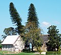
The historic timber general store at Woodville.
Australia New South Wales location map blank.svg
Red pog.svg
Woodville
Coordinates 32°40′33″S151°36′34.7″E / 32.67583°S 151.609639°E / -32.67583; 151.609639 Coordinates: 32°40′33″S151°36′34.7″E / 32.67583°S 151.609639°E / -32.67583; 151.609639
Population604 (2011 census) [1] [Note 1]
 • Density25.6/km2 (66/sq mi) 18
Postcode(s) 2321
Elevation6 m (20 ft) [Note 2]
Area21.5 km2 (8.3 sq mi) [Note 3]
Time zone AEST (UTC+10)
 • Summer (DST) AEDT (UTC+11)
Location
LGA(s)
Region Hunter [2]
County Durham [4]
Parish Butterwick [4]
State electorate(s) Port Stephens [5]
Federal division(s) Paterson [6]
Mean max temp [7] Mean min temp [7] Annual rainfall [7]
29.6 °C
85 °F
6.1 °C
43 °F
925.2 mm
36.4 in
Suburbs around Woodville:
Tocal Duns Creek, Butterwick Seaham
Mindaribba Woodville Seaham
Bolwarra Heights Wallalong Seaham

Woodville is a rural suburb in the Hunter Region of New South Wales, Australia that is shared between the Port Stephens and Maitland local government areas (LGA). [2] [3] Most of the suburb lies to the east of the Paterson River in the Port Stephens LGA while a small area of approximately 1.3 square kilometres (0.5 sq mi), to the west of the Paterson, is within the boundaries of the Maitland LGA. [8]

Contents

Land use

Woodville's primary land use is agricultural, although housing and small-acre rural residential lots are increasingly significant. Its agriculture consists mainly of broad-acre hay production, along with beef cattle grazing, turf-farming, poultry and olive production. It sits on the floodplains of the lower Hunter River and is subject to periodic flooding.

Township

The suburb's centre consists of only a few buildings: an old timber shop, a few houses of mixed age and design and the All Saints sandstone gothic style church. The church is now privately owned and although no longer used for religious services, the heritage listed chapel is non-denominational and available for weddings both civil and religious while the timber hall associated with the church is now a function centre.

History

The Woodville region was occupied originally by Aboriginals, most likely the Worimi people. It offered abundant natural resources, with rivers, extensive wetlands, lakes, open woodland and rainforest. In the early 19th century, the first Europeans known to enter the region were timber-getters seeking to exploit the extensive red cedar trees that grew on and near the banks of the Paterson and Hunter rivers. Felled trees were floated down-river to timber mills in Newcastle.

Woodville has some significant historical buildings, such as Dunmore House, the Woodville shop/general store is Australia's oldest continually running business still carrying on the same services it was licensed for in 1844. The homestead of the historical property Stradbroke, which is listed in the Australian Heritage Database. [9] Increasingly, traditional farms are being subdivided for semi-rural small holdings.

The Woodville School of Arts dates to 1877. The Gothic Revival All Saints Church is heritage listed and was officially opened in 1864, it features impressive arched and leadlight windows following its restoration work in 1922, the Hall associated with the church was constructed in the 1890s and is of architectural interest. Iona School dates to 1918. Weddings and receptions are regularly held on the site which is unique in the region.

Woodville was also the name of a suburb in Sydney, causing confusion until the name of Woodville in Sydney was transposed to the new name of Villawood.

Dunmore Bridge

The heritage-listed Dunmore Bridge over the Paterson River is a wooden Allan truss lift-span bridge that was built in 1899. [10] The lift-span is intact although now inoperative. The bridge is located on Clarence Town Road, the main road between Maitland and Paterson, Seaham, Clarence Town and Dungog.

Notes

  1. ABS QuickStats data for "Woodville" includes residents from the adjacent suburb of Butterwick, while excluding that part of Woodville that lies in the Maitland LGA.
  2. Average elevation of the suburb as shown on 1:100000 map 9232 NEWCASTLE.
  3. Area calculation is based on 1:100000 map 9232 NEWCASTLE.

Related Research Articles

Hexham, New South Wales Suburb of Newcastle, New South Wales, Australia

Hexham is a suburb of the city of Newcastle, about 15 km (9 mi) inland from the Newcastle CBD in New South Wales, Australia on the bank of the Hunter River.

Morpeth, New South Wales Suburb of Maitland, New South Wales, Australia

Morpeth is a suburb of the city of Maitland in the Hunter Region of New South Wales, Australia. It is on the southern banks of the Hunter River at the border between the City of Maitland and Port Stephens Council LGAs. The major population centre, where almost all residents of the suburb reside, is the historical town of Morpeth which takes its name from Morpeth, Northumberland, near Newcastle upon Tyne, in England.

Raymond Terrace Town in New South Wales, Australia

Raymond Terrace is a town in the Hunter Region of New South Wales, Australia, about 26 km (16 mi) by road north of Newcastle on the Pacific Highway. Established in 1837 it is situated at the confluence of the Hunter and Williams rivers. The town was named after Lieutenant Raymond, who had explored the Hunter River in 1797 and described the terraced appearance of trees in the area. Governor Lachlan Macquarie camped in the area in 1818, using "Raymond Terrace" as the name for the place where his party had camped.

Brandy Hill, New South Wales Suburb of Port Stephens Council, New South Wales, Australia

Brandy Hill is a suburb of the Port Stephens local government area in the Hunter Region of New South Wales, Australia. It was originally farmland but was subdivided in the 1980s and now supports a population of almost 700 people living on large, primarily residential, blocks. It overlooks working farmland and offers superb views of the greater Morpeth area, with visibility extending to Maitland.

Karuah, New South Wales Suburb of Port Stephens Council, New South Wales, Australia

Karuah is a locality in both the Port Stephens and Mid-Coast Councils in the Hunter Region of New South Wales, Australia. It is thought that the name means 'native plum tree' in the local Aboriginal dialect.

Tarro, New South Wales Suburb of Newcastle, New South Wales, Australia

Tarro is a north-western suburb of the Newcastle City Council local government area in the Hunter Region of New South Wales, Australia. It, and parts of nearby Beresfield, was originally known as Upper Hexham, "lower" Hexham being an older settlement located about 5 kilometres (3 mi) to the east on the Hunter River. The name "Tarro" reportedly means "stone" in an Aboriginal language.

Woodberry, New South Wales Suburb of Maitland, New South Wales, Australia

Woodberry is one of the easternmost suburbs of the City of Maitland in the Hunter Region of New South Wales, Australia. At the 2011 census, Woodberry's population was 3,155. Most of the population lives in residential subdivisions while almost 84% of the suburb's land is rural in nature. Rental accommodation is occupied by 33.33% of the residents.

Salt Ash, New South Wales Suburb of Port Stephens Council, New South Wales, Australia

Salt Ash is a rural suburb of the Port Stephens local government areas in the Hunter Region of New South Wales, Australia. It is located on the main road between Newcastle and Nelson Bay but is largely undeveloped, partly because it is the location of the Salt Ash Air Weapons Range which is used by pilots from RAAF Base Williamtown for training purposes.

Williamtown, New South Wales Suburb of Port Stephens Council, New South Wales, Australia

Williamtown is a rural suburb of the Port Stephens local government area in the Hunter Region of New South Wales, Australia. It is located on the main road between Newcastle and Nelson Bay.

Tomago, New South Wales Suburb of Port Stephens Council, New South Wales, Australia

Tomago is a combined industrial/semi-rural suburb of the Port Stephens local government area in the Hunter Region of New South Wales, Australia. It is located just north of the Hunter River and west of the body of water known as Fullerton Cove. Tomago means "sweet water" in the local Aboriginal language. In 2016 277 lived in Tomago with a median age of 55, 72.7% born in Australia and 80.4% only speaking English at home.

Glen Oak, New South Wales Suburb of Port Stephens Council, New South Wales, Australia

Glen Oak is a small community in the Hunter Region of New South Wales, Australia, shared between the Port Stephens and Dungog local government areas (LGA). Approximately two thirds of the suburb's 45.1 square kilometres (17.4 sq mi) is located within the Port Stephens LGA while the remaining third, which is sparsely populated, is located in Dungog Shire.

Duns Creek, New South Wales Suburb of Port Stephens Council, New South Wales, Australia

Duns Creek is a rural residential suburb in the Hunter Region of New South Wales, Australia, located near the historic village of Paterson in the north-western corner of the Port Stephens Council local government area.

Hinton, New South Wales Suburb of Port Stephens Council, New South Wales, Australia

Hinton is a suburb of the Port Stephens local government area in the Hunter Region of New South Wales, Australia. Primarily rural, the largest population centre is the township of Hinton, which is situated on the Paterson River, near to the confluence of the Hunter and Paterson rivers. In 1835 the post office requested a name for the town and the surveyor general suggested Hinton prior to this it was known as the second arm of the hunter river. The first European settlers were 12 ex convicts in 1818.

Kooragang Suburb of Newcastle, New South Wales, Australia

Kooragang is the northernmost and largest suburb of the city of Newcastle, in the Hunter Region of New South Wales, Australia. Dominated by Kooragang Island, the eastern part of the suburb is primarily industrial, while the western part of the suburb consists of nature reserves. Covering an area of 35.4 km2 (13.7 sq mi), at the 2016 census, there were no people living in the suburb.

Osterley, New South Wales Suburb of Port Stephens Council, New South Wales, Australia

Osterley is a small rural suburb of the Port Stephens local government area in the Hunter Region of New South Wales, Australia. Most of the small population lives in the elevated part of the suburb along Hinton Road, east of Barties Creek which is a tributary of the Hunter River. The area to the west of Barties creek is low-lying and subject to periodic flooding. .In 2016 117 people live there with a median age of 46.

Nelsons Plains, New South Wales Suburb of Port Stephens Council, New South Wales, Australia

Nelsons Plains is a primarily rural suburb of the Port Stephens local government area in the Hunter Region of New South Wales, Australia. It is situated on Seaham Road between the Hunter and Williams rivers. At the 2016 census the suburb had a population of 362.

East Seaham, New South Wales Suburb of Port Stephens Council, New South Wales, Australia

East Seaham is a primarily rural suburb of the Port Stephens local government area in the Hunter Region of New South Wales, Australia. It is situated on the east bank of the Williams River, opposite Glen Oak and Seaham. At the 2011 census, the population of East Seaham and the adjacent suburb of Balickera was 359, with the two suburbs having an average population density of 5.5/km2 (14/sq mi).

Wallalong, New South Wales Suburb of Port Stephens Council, New South Wales, Australia

Wallalong is a rural suburb of the Port Stephens local government area in the Hunter Region of New South Wales, Australia. The suburb is bisected by High Street, along which a small residential zone of 938 people exists. To the east and west of this area the suburb is almost exclusively rural.

Campvale, New South Wales Suburb of Port Stephens Council, New South Wales, Australia

Campvale is a sparsely populated rural suburb of the Port Stephens local government area in the Hunter Region of New South Wales, Australia.

Ferodale, New South Wales Suburb of Port Stephens Council, New South Wales, Australia

Ferodale is a sparsely populated rural suburb of the Port Stephens local government area in the Hunter Region of New South Wales, Australia. A large portion of the suburb is occupied by Grahamstown Dam, the lower Hunter Region's main water storage reservoir.

References

  1. Australian Bureau of Statistics (31 October 2012). "Woodville (State Suburb)". 2011 Census QuickStats. Retrieved 24 October 2012. OOjs UI icon edit-ltr-progressive.svg
  2. 1 2 3 "Suburb Search – Local Council Boundaries – Hunter (HT) – Port Stephens". New South Wales Division of Local Government . Retrieved 17 June 2008.
  3. 1 2 "Suburb Search – Local Council Boundaries – Hunter (HT) – Maitland City Council". New South Wales Division of Local Government . Retrieved 17 June 2008.
  4. 1 2 "Woodville". Geographical Names Register (GNR) of NSW. Geographical Names Board of New South Wales . Retrieved 17 June 2008. OOjs UI icon edit-ltr-progressive.svg
  5. "Port Stephens". New South Wales Electoral Commission . Retrieved 23 November 2019.
  6. "Paterson". Australian Electoral Commission. 19 October 2007. Retrieved 17 June 2008.
  7. 1 2 3 "Paterson (Tocal AWS)". Climate statistics for Australian locations. Bureau of Meteorology . Retrieved 17 June 2008.
  8. "Woodville". Land and Property Management Authority - Spatial Information eXchange. New South Wales Land and Property Information . Retrieved 17 June 2008.
  9. "Stradbroke House and Outbuildings, Paterson Rd, Woodville, NSW, Australia (Place ID 1326)". Australian Heritage Database . Department of the Environment. 21 March 1978. Retrieved 17 June 2008.
  10. "Dunmore Bridge over the Paterson River". New South Wales State Heritage Register . Office of Environment and Heritage. H01467. Retrieved 18 May 2018.