Hunter River (New South Wales)

Last updated

Hunter River
Coquon P.T.O., First Hunter Creek, Coal River [1]
Newcastle - Bulk carrier passing Nobbys.jpg
Ship entering the mouth of the Hunter River at Newcastle
EtymologyIn honour of John Hunter [1]
Native nameCoquun (Awabakal)
Location
Country Australia
State New South Wales
Region NSW North Coast (IBRA), Sydney Basin (IBRA), Hunter
Local government areas Upper Hunter, Muswellbrook, Singleton, Maitland, Dungog, Port Stephens, Newcastle
Major settlements and towns Aberdeen, Muswellbrook, Denman, Jerrys Plains, Singleton, Maitland, Morpeth, Raymond Terrace, Newcastle
Physical characteristics
Source Mount Royal Range, Liverpool Range
  locationwithin Barrington Tops National Park, Upper Hunter
  coordinates 31°53′36.5″S151°27′04.4″E / 31.893472°S 151.451222°E / -31.893472; 151.451222
  elevation1,420 m (4,660 ft)
Mouth Tasman Sea
  location
between Nobbys Head and Stockton
  coordinates
32°55′S151°47′E / 32.92°S 151.79°E / -32.92; 151.79
  elevation
0 m (0 ft)
Length300 km (190 mi) [2]
Basin size21,367 km2 (8,250 sq mi) [2]
Discharge 
  locationNear mouth
  average52.4 m3/s (1,650 GL/a) [3]
Basin features
Tributaries 
  left Moonan Brook, Stewarts Brook, Paterson River, Williams River
  right Pages Creek, Pages River, Goulburn River, Wollombi Brook
BridgesEllerston, Aberdeen, Muswellbrook, Denman, Golden Highway, Singleton (x3), Elderslie, Melville Ford, Bolwarra Heights (rail), Maitland, Lorn, Morpeth, Millers Forest/Nelsons Plains, Hexham, Ash Island, Kooragang (rail), Tourle Street, Stockton
National park Barrington Tops
[4] [5]

The Hunter River (Wonnarua: Coquun [6] ) is a major river in New South Wales, Australia. The Hunter River rises in the Liverpool Range and flows generally south and then east, reaching the Tasman Sea at Newcastle, the second largest city in New South Wales and a major harbour port. Its lower reaches form an open and trained mature wave dominated barrier estuary. [7]

Contents

Course and features

Map of the drainage area of the Hunter River, 1901 Hunter River 1901 SLNSW FL10521075.jpg
Map of the drainage area of the Hunter River, 1901

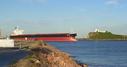
The Hunter River rises on the western slopes of Mount Royal Range, part of the Liverpool Range, within Barrington Tops National Park, east of Murrurundi, and flows generally northwest and then southwest before being impounded by Lake Glenbawn; then flowing southwest and then east southeast before reaching its mouth of the Tasman Sea, [1] in Newcastle between Nobbys Head and Stockton. The river is joined by ten tributaries upstream of Lake Glenbawn; and a further thirty-one tributaries downstream of the reservoir. The main tributaries are the Pages, Goulburn, Williams and the Paterson rivers and the Moonan, Stewarts and Wollombi brooks. East of Hexham, the river splits into two main channels, separated by the Ramsar-protected Kooragang Wetlands that feeds Milham Ponds, Wader Pond, Swan Pond and a series of smaller wetland pondages. The southern arm of the river also creates Hexham Island, while the northern creates Smiths Island and flows in Fullerton Cove. The two channels converge at Walsh Point, reaching confluence with Throsby Creek adjacent to the Newcastle central business district, before reaching the river mouth. The Hunter River descends 1,397 m (4,583 ft) over its 468 km (291 mi) course from the high upper reaches, through the Hunter Valley, and out to sea. [4]

The Hunter River is subject to substantial flooding, which Glenbawn Dam, near Scone, was constructed to ameliorate. Major floods have occurred on the Hunter including the flood of 1955 that caused devastation to townships along the river, especially Maitland. Severe flooding again occurred in June 2007 and again in 2015.

Towns along the Hunter River, from upstream to downstream, include Aberdeen, Muswellbrook, Denman, Jerrys Plains, Singleton, Maitland, Morpeth and Raymond Terrace.

At Hexham, the river is transversed by the Pacific Highway; while at Singleton and again at Aberdeen, the river is crossed by the New England Highway; and the Golden Highway crosses the river to the north and to the southeast of Denman.

Hunter Valley

The Hunter Valley is one of the best routes to the interior of the state with access relatively unimpeded by mountains and other obstacles. It is the largest area of relatively low-lying land near the coast of New South Wales, and owing to the shielding by rugged ranges to its north, is much drier than any other coastal region of the state. Annual rainfall ranges from 1,100 mm (43 in) at Newcastle to only 640 mm (25 in) at Merriwa and Scone in the upper reaches. In the driest years rainfall can be as low as 600 mm (24 in) at Newcastle and 375 mm (15 in) in the upper valley.[ citation needed ]

Around the Barrington Tops on the northern side of the valley, however, annual precipitation can be as high as 2,000 mm (79 in), not all of which falls as rain since July temperatures are often below 0 °C (32 °F). In the lower areas, summer maxima are usually around 27 °C (81 °F) and winter maxima around 16 °C (61 °F).

Except for the driest parts of Tasmania and a small area of the Monaro between Cooma and Nimmitabel, the Hunter Valley is the southern limit of rich "black earths" (actually black cracking clays). These are the only soils in all of Australia with reasonable levels of soluble phosphorus,[ citation needed ] with the result that upstream from Singleton very rich pasture land with many thoroughbred horse studs occurs. Around Merriwa and south of Singleton, the soils are very infertile sands more typical of Australia as a whole, and the dominant land use is extensive grazing.[ citation needed ]

Parts of the Hunter Valley are important for grape growing and wine producing. [8] The Hunter Valley is also one of Australia's most important coal mining areas. [9] The Hunter River is threatened by drought, climate change [ citation needed ] and proposed loss of water due to coal mining.[ citation needed ] The region is also favoured by thoroughbred horse breeders and stud farms.

Hunter Valley coal operations.jpg
The Hunter River meanders around coal mines and power plants in this aerial view.

History

The Hunter River has been inhabited for thousands of years by the Wonnarua Aboriginal people, who called it the Coquun ( /kˈkwɪn/ ), meaning "fresh water". The Lower Hunter River nearer to the coast is the traditional country of the Awabakal people. Both groups spoke a similar language.

The river was first settled by European explorers in the 1790s. In June 1796, fishermen sheltering from bad weather discovered coal there, and the river was initially called Coal River. In 1797, it was formally named the Hunter, after Captain John Hunter who was Governor of the British colony in New South Wales at that time. [1] [10]

Between 1826 and 1836, convicts built the 264 km (164 mi) long Great North Road that links Sydney to the Hunter Region. [11]

Related Research Articles

<span class="mw-page-title-main">Hunter Region</span> Region in New South Wales, Australia

The Hunter Region, also commonly known as the Hunter Valley, Newcastle Region, or simply Hunter, is a region in northern New South Wales, Australia, extending from approximately 162 km (101 mi) to 310 km (193 mi) north of Sydney. It contains the Hunter River and its tributaries with highland areas to the north and south. Situated at the northern end of the Sydney Basin bioregion, the Hunter Valley is one of the largest river valleys on the NSW coast, and is most commonly known for its wineries and coal industry.

<span class="mw-page-title-main">New England Highway</span> Highway in New South Wales and Queensland

New England Highway is an 883-kilometre (549 mi) long highway in Australia running from Yarraman, north of Toowoomba, Queensland, at its northern end to Hexham at Newcastle, New South Wales, at its southern end. It is part of Australia's National Highway system, and forms part of the inland route between Brisbane and Sydney.

<span class="mw-page-title-main">Golden Highway</span> Highway in New South Wales

Golden Highway is a 313-kilometre (194 mi) highway, located in the Hunter and Orana regions of New South Wales, Australia. It runs eastwards from Dubbo towards Newcastle on the coast, allowing road transport to avoid travelling over the Blue Mountains to Sydney, and is designated route B84.

<span class="mw-page-title-main">Hexham, New South Wales</span> Suburb of Newcastle, New South Wales, Australia

Hexham is a suburb of the city of Newcastle, about 15 km (9 mi) inland from the Newcastle CBD in New South Wales, Australia on the bank of the Hunter River.

<span class="mw-page-title-main">Singleton, New South Wales</span> Town in New South Wales, Australia

Singleton is a town on the banks of the Hunter River in New South Wales, Australia. Singleton is 202km (89 mi) north-north-west of Sydney, and 70 km (43 mi) north-west of Newcastle. At June 2018, Singleton had an urban population of 16,346.

<span class="mw-page-title-main">Glenbawn Dam</span> Dam in Hunter Valley, New South Wales

Glenbawn Dam is a major ungated earth and rock fill with clay core embankment dam with concrete chute spillway plus fuse plugs across the Hunter River upstream of Aberdeen in the Hunter Valley of New South Wales, Australia. The dam's purpose includes flood mitigation, hydro-electric power, irrigation, water supply and conservation. The impounded reservoir is called Lake Glenbawn.

<span class="mw-page-title-main">Goulburn River (New South Wales)</span> River in New South Wales, Australia

Goulburn River, a perennial river of the Hunter River catchment, is located in the Upper Hunter region of New South Wales, Australia.

<span class="mw-page-title-main">Wonnarua</span> An Aboriginal Australian people of New South Wales

The Wonnarua people, otherwise written Wanarruwa, are a group of Aboriginal Australian people united by strong ties of kinship, and who survived in family groups or clans scattered along the inland area of what is now known as the Upper Hunter Valley, New South Wales, Australia. Their creation spirit is Baiami, also known as Koin, the creator of all things and the Keeper of the Valley.

<span class="mw-page-title-main">Main North railway line, New South Wales</span> Railway line in New South Wales, Australia

The Main North Line is a major railway in New South Wales, Australia. It runs through Strathfield to Armidale. The line is the main line between Sydney and Armidale. As of 1988, the line closed progressively north of Armidale with services gradually withdrawn till 2004, with the main route between Sydney and Brisbane now the North Coast line.

<span class="mw-page-title-main">Glennies Creek Dam</span> Dam in New South Wales

Glennies Creek Dam is a minor ungated concrete faced curved earth and rockfill embankment dam with an uncontrolled rock cut spillway across the Glennies Creek, upstream of Singleton, in the Hunter region of New South Wales, Australia. The dam's purpose includes flood mitigation, irrigation, water supply and conservation. The impounded reservoir is called Lake Saint Clair.

<span class="mw-page-title-main">Greta, New South Wales</span> Town in New South Wales, Australia

Greta is a small town in the Hunter Region of New South Wales, Australia.

<span class="mw-page-title-main">Kooragang</span> Suburb of Newcastle, New South Wales, Australia

Kooragang is the northernmost and largest suburb of the city of Newcastle, in the Hunter Region of New South Wales, Australia. Dominated by Kooragang Island, the eastern part of the suburb is primarily industrial, while the western part of the suburb consists of nature reserves. Covering an area of 35.4 km2 (13.7 sq mi), at the 2016 census, there were no people living in the suburb.

<span class="mw-page-title-main">Karuah River</span> River in New South Wales, Australia

Karuah River, an open semi-mature tide dominated drowned valley estuary is located in the Mid North Coast and Hunter regions of New South Wales, Australia.

<span class="mw-page-title-main">Barnard River</span> River in New South Wales, Australia

Barnard River, a perennial river of the Manning River catchment, is located in the Northern Tablelands and Mid North Coast districts of New South Wales, Australia.

Bow River, a partly perennial stream of the Hunter River catchment, is located in the Hunter district of New South Wales, Australia.

Bylong River, a perennial river of the Hunter River catchment, is located in the Central Tablelands and Upper Hunter regions of New South Wales, Australia.

<span class="mw-page-title-main">Pages River</span> River in New South Wales, Australia

Pages River, a perennial river of the Hunter River catchment, is located in the Hunter region of New South Wales, Australia.

<span class="mw-page-title-main">Allyn River</span> River in New South Wales, Australia

Allyn River, a perennial stream of the Hunter River catchment, is located in the Hunter region of New South Wales, Australia.

Moonan Brook, a mostly perennial stream of the Hunter River catchment, is located in the Hunter region of New South Wales, Australia.

Rouchel Brook, a perennial stream of the Hunter River catchment, is located in the Hunter region of New South Wales, Australia.

References

  1. 1 2 3 4 "Hunter River". Geographical Names Register (GNR) of NSW. Geographical Names Board of New South Wales . Retrieved 22 March 2013. OOjs UI icon edit-ltr-progressive.svg
  2. 1 2 "Estuaries of NSW: Hunter River". Office of Environment & Heritage . Government of New South Wales. 26 April 2012. Retrieved 22 March 2013.
  3. "East Coastal Watersheds".
  4. 1 2 "Map of Hunter River (1), NSW". Bonzle Digital Atlas of Australia. Retrieved 22 March 2013.
  5. "Map of Hunter River (2), NSW". Bonzle Digital Atlas of Australia. Retrieved 22 March 2013.
  6. "Media Release, Indigenous Naming Comes To Newcastle" (PDF). Geographical Names Board NSW Government. Archived from the original (PDF) on 4 March 2022. Retrieved 23 July 2022.
  7. Roy, P. S; Williams, R. J; Jones, A. R; Yassini, I; et al. (2001). "Structure and Function of South-east Australian Estuaries". Estuarine, Coastal and Shelf Science . 53: 351–384. doi:10.1006/ecss.2001.0796.
  8. "Hunter Valley". Wine Australia. Retrieved 9 September 2020.
  9. Murray, James (12 February 2020). "What are the five biggest coal mines in fossil fuel-reliant Australia?". NS ENERGY. Retrieved 2020-09-09.
  10. Clark, Manning (1981). "Chapter 8". A History of Australia. Vol. 1 (reprint ed.). ISBN   0-522-84008-6.
  11. "The Convict Trail Project". Archived from the original on 17 October 2013. Retrieved 18 January 2020.