
Hexham is a suburb of the city of Newcastle, about 15 km (9 mi) inland from the Newcastle CBD in New South Wales, Australia on the bank of the Hunter River.

Singleton is a town on the banks of the Hunter River in New South Wales, Australia. Singleton is 144 km (89 mi) north-north-west of Sydney, and 70 km (43 mi) northwest of Newcastle. At June 2018, Singleton had an urban population of 16,346.

Gloucester, a town in dairy and beef cattle country, is located in Mid-Coast Council, within the Manning district on the Mid North Coast of the state of New South Wales, Australia.

Thirlmere is a small semi-rural town in the Macarthur Region of New South Wales, Australia, in Wollondilly Shire. Popularly known for its railway origins, the town is located 89 km south west of Sydney, one third of the distance from Sydney to Canberra. At the 2016 census, Thirlmere had a population of 4,046.
Mittagong is a town located in the Southern Highlands of New South Wales, Australia, in Wingecarribee Shire. The town acts as the gateway to the Southern Highlands when coming from Sydney. Mittagong is situated at an elevation of 635 metres (2,083 ft). The town is close to Bowral, Berrima, Moss Vale and the Northern Villages such as Yerrinbool and Colo Vale. Moreover, Mittagong is home to many wineries of the Southern Highlands which has been a recent growing wine and cellar door region.

Kurri Kurri is a small town in the Hunter Region of New South Wales, Australia, in the Cessnock LGA. At the 2016 census, its population was 6,044. Kurri Kurri is the largest town in a group of towns and hamlets, including Stanford Merthyr, Pelaw Main, Weston, Abermain and Heddon Greta, called Kurri Kurri – Weston by the ABS. Its estimated population was 17,241 at 2016 census.
Jerrys Plains is a village in the Hunter Region in New South Wales, Australia about 33 kilometres west of Singleton on the Golden Highway. The surrounding countryside is home to some substantial horse-breeding properties, notably the Australian branch of Ireland's giant Coolmore Stud, as well as viticulture and coal mining.
Broke is a village of approximately 292 people in the Hunter Region of New South Wales, Australia in Singleton Shire. It is located 157 kilometres (98 mi) to the north of Sydney on the original early colonial road from Sydney to Singleton.
Lochinvar is a village in the Hunter Region of New South Wales, Australia, eleven kilometres west of the regional centre of Maitland. Lochinvar is within the boundaries of the City of Maitland local government area and is named after Lochinvar, a loch in southern Scotland. A historic home and property called "Windermere" is located near the town. There is also a locally famous country department store called "Aird's of Lochinvar" on the Maitland side.

Scarborough is a small northern seaside suburb of Wollongong on the south coast of New South Wales, Australia. It sits in the northern Illawarra region on a narrow stretch between the Illawarra escarpment and sea cliffs.

Abernethy is a small town in the City of Cessnock, in the Hunter Region in the state of New South Wales, Australia. Abernethy is located 8 kilometres south-east of the town of Cessnock, NSW and is adjacent to Werakata National Park and the Aberdare State Forest. The town was founded near a coal mine and some of the historic buildings remain.
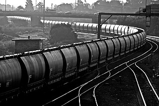
The Hunter Valley Coal Chain (HVCC) is the chain of coal delivery in New South Wales, Australia from coal mines in the Hunter Region to the Port of Newcastle and domestic coal-fired power stations in the Hunter Valley. The HVCC essentially follows the path of the Hunter River travelling south-east from the mining areas in the Hunter Valley to Newcastle.

Stratford is a rural locality in the Mid-Coast Council local government area in the Hunter Region of New South Wales, Australia. The largest population centre in the area is the town of Stratford, which is approximately 14 kilometres (9 mi) south of Gloucester and 109 km (68 mi) north of Newcastle. Stratford, which is next to the Avon River, is on Bucketts Way, 66 km (41 mi) from the Pacific Highway, the nearest major highway.

Acland is a rural town and locality in the Toowoomba Region, Queensland, Australia. In the 2016 census, Acland had a population of 32 people.
Some of the more notable coal companies in Australia are the following:
Avondale is a village in New South Wales. It is located just west of Lake Illawarra. At the 2016 census, it had a population of 1,653.

Port Kembla is a man-made cargo port or artificial harbour, with an outer harbour protected by breakwaters and an inner harbour constructed by dredging, located in the Illawarra region of New South Wales, Australia.
The Ashton coal mine is located in New South Wales, Australia. The mine is located next to Camberwell in the Upper Hunter Valley region, 15 km northwest of Singleton and 32 km southeast of Muswellbrook. The mine has coal reserves amounting to 322.5 million tonnes of coking coal. The mine applies longwall mining and currently has an annual production capacity of 3 million tonnes.
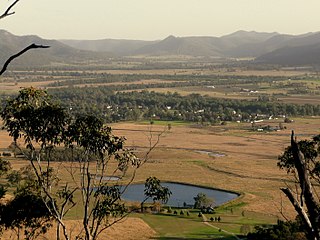
Bulga is a locality in the Singleton Council region of New South Wales, Australia. It had a population of 354 as of the 2016 census. The name is derived from an Aboriginal word for "mountain" or "isolated hill or mountain".
Warkworth is a locality in the Singleton Council region of New South Wales, Australia. It had a population of 49 as of the 2016 census.
