
Milbrodale is a village in the Hunter Region of New South Wales, Australia. It is in the local government area of Singleton Council.
Milbrodale is a village in the Hunter Region of New South Wales, Australia. It is in the local government area of Singleton Council.
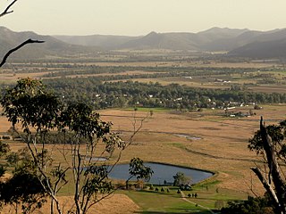
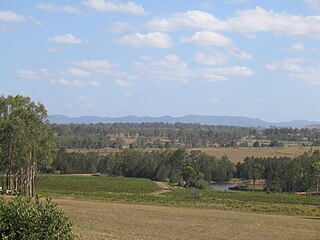
Milbrodale is set in a rural area 23 kilometres south of Singleton. To the north of Milbrodale is Darkey Creek, while to the east is Wollombi Brook. To the west is the rugged sandstone wilderness of the Wollemi National Park, the second-largest national park in New South Wales. Milbrodale is approximately twenty-nine kilometres from Singleton and seventy-eight kilometres from the city of Newcastle. [1]
Milbrodale was first established by the Rev. Richard Hill in 1832. Hill had arrived from England to assist with the ministering of the colony at Sydney, and worked as assistant to the minister at St Philip's Church in Sydney. Later, he became minister at St James's Church, Sydney (designed by Francis Greenway). Eventually, Governor Lachlan Macquarie gave him a land grant of 1,200 acres (4.9 km2) in the Hunter Valley. After journeying along a track that was the beginning of the Great North Road, Hill arrived in the Hunter Valley and built a stone house at the junction of Wollombi Brook and Parsons Creek. He named his property Milbro Dale, after his mother (her name had been Marlborough, which was commonly shortened to Milbro). Hill died in 1836 and his wife Phoebe Sapphira returned to Sydney after selling the farm. [2] The property changed hands several times over the years but eventually deteriorated and was demolished in 1978. [3]
The village grew as time went by, but the local children had to go to school at the nearby village of Bulga, transported by a horse and cart service subsidised by the Government. A public school was finally opened at Milbrodale in 1921 on a 5-acre (20,000 m2) property obtained by Government grant. [4]
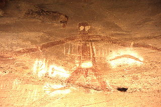
The most significant feature of Milbrodale is an eighty-hectare site containing rock shelters with many signs of Aboriginal occupation. Excavations carried out by staff from the Australian Museum, Sydney, produced much evidence of the "Small Tool Phase" of Aboriginal history. One of the main features is a rock shelter popularly known as Baiame Cave, which contains a group of Aboriginal paintings. The central figure is a large male figure that may represent Baiame, the Sky Father. [5] The site is on private property.
The cave is listed on the New South Wales Heritage Register. [6]


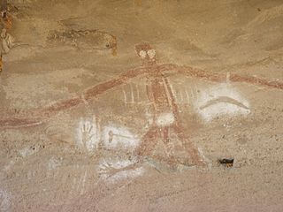
In Australian Aboriginal mythology, Baiame is the creator god and sky father in the Dreaming of several Aboriginal Australian peoples of south-eastern Australia, such as the Wonnarua, Kamilaroi, Guringay, Eora, Darkinjung, and Wiradjuri peoples.
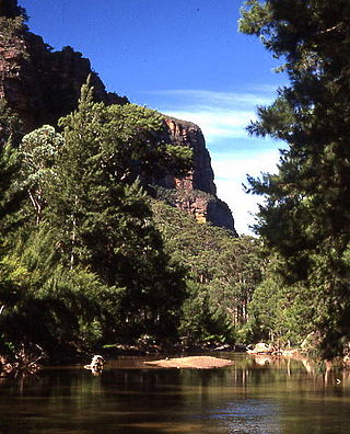
The Wollemi National Park is a protected national park and wilderness area that is located in the Central West and Hunter region of New South Wales, in eastern Australia. The 501,703-hectare (1,239,740-acre) park, the second largest national park in New South Wales, contains the 361,113-hectare (892,330-acre) Wollemi Wilderness – the largest such wilderness area in Australia – and is situated approximately 130 kilometres (81 mi) northwest of Sydney.

The Yengo National Park is a protected national park that is located in the Lower Hunter region of New South Wales, in eastern Australia. The 154,328-hectare (381,350-acre) park is situated 213 kilometres (132 mi) northwest of Sydney, 40 kilometres (25 mi) south of Cessnock, 121 kilometres (75 mi) northwest of Gosford, and 91 kilometres (57 mi) southwest of Newcastle. The average elevation of the terrain is 309 metres.

The Hunter River is a major river in New South Wales, Australia. The Hunter River rises in the Liverpool Range and flows generally south and then east, reaching the Tasman Sea at Newcastle, the second largest city in New South Wales and a major harbour port. Its lower reaches form an open and trained mature wave dominated barrier estuary.

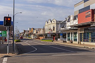
Singleton is a town on the banks of the Hunter River in New South Wales, Australia. Singleton is 202km (89 mi) north-north-west of Sydney, and 70 km (43 mi) north-west of Newcastle. At June 2018, Singleton had an urban population of 16,346.

Branxton is a town in the Hunter Region of New South Wales, Australia. Branxton is 171 kilometres (106 mi) north of Sydney via the Sydney-Newcastle Freeway and New England Highway. Branxton is located mostly in the City of Cessnock, but part of it is in Singleton Shire.

Hunters Hill is a suburb of the lower north shore of Sydney, in the state of New South Wales, Australia. Hunters Hill is located 9 kilometres (5.6 mi) north-west of the Sydney central business district and is the administrative centre for the local government area of the Municipality of Hunter's Hill.

The Wonnarua people, otherwise written Wanarruwa, are a group of Aboriginal Australian people united by strong ties of kinship, and who survived in family groups or clans scattered along the inland area of what is now known as the Upper Hunter Valley, New South Wales, Australia. Their creation spirit is Baiami, also known as Koin, the creator of all things and the Keeper of the Valley.
Cessnock is a city in the Hunter Valley of New South Wales, Australia, about 52 km (32 mi) by road west of Newcastle. It is the administrative centre of the City of Cessnock LGA and was named after an 1826 grant of land called Cessnock Estate, which was owned by John Campbell. The local area was once known as "The Coalfields", and it is the gateway city to the vineyards of the Hunter Valley, which includes Pokolbin, Mount View, Lovedale, Broke, Rothbury, and Branxton.
Cessnock is an electoral district of the Legislative Assembly in the Australian state of New South Wales in the rural fringe of the Hunter. It is represented by Clayton Barr of the Labor Party. It includes all of City of Cessnock, part of Singleton Council and a small part of the City of Lake Macquarie.
Broke is a village of approximately 292 people in the Hunter Region of New South Wales, Australia in Singleton Shire. It is located 157 kilometres (98 mi) to the north of Sydney on the original early colonial road from Sydney to Singleton.

Mount Yengo is a mountain that is located in the Lower Hunter region of New South Wales, in eastern Australia. The 668-metre (2,192 ft) mountain is part of the Calore Range, part of the Great Dividing Range, and is situated within the Yengo National Park, approximately 3 kilometres (1.9 mi) east of the Macdonald River and 17 kilometres (11 mi) east by south of Putty.

Mount View, New South Wales is a rural locality located in the Hunter Region wine region in New South Wales Australia. It is located Between Cessnock and Wollombi and is a part of the City of Cessnock local government area. It has ideal climate, soil, and temperature for viticultural pursuits, which have been practised here since the mid-19th century. The road from Cessnock to Mount View provides access to the Great North Walk, and to lookouts with excellent views of the Hunter Region.

Wollombi is a small village in the Hunter Region of New South Wales, Australia. It is within the Cessnock City Council LGA, situated 29 kilometres (18 mi) southwest of Cessnock and 128 km (80 mi) north of Sydney. To the south is the village of Laguna, to the east, the village of Millfield and to the north, the village of Broke.
Aboriginal sites of New South Wales consist of a large number of places in the Australian state of New South Wales where it is still possible to see visible signs of the activities and culture of the Australian Aboriginals who previously occupied these areas.
Cedar Creek, a perennial stream of the Hunter River catchment, is located in the Hunter district of New South Wales, Australia.

Congewai Creek, a watercourse of the Hunter River catchment, is located in the Hunter district of New South Wales, Australia.
Bulga is a locality in the Singleton Council region of New South Wales, Australia. It had a population of 354 as of the 2016 census. The name is derived from an Aboriginal word for "mountain" or "isolated hill or mountain".

Baiame Cave is a heritage-listed cave and cultural site of the Wonnarua people at Milbrodale, Singleton Council, New South Wales, Australia. It is also known as Baiame’s Cave, Creator Cave, Dhurramulan, Goign, Wabooee, Baiamai, Biami, Baimae, Biamie, Biaime, Byarmie and Byarme. It was added to the New South Wales State Heritage Register on 31 July 2015.
The Central Hunter Valley eucalypt forest and woodland is a grassy woodland community situated in the Hunter Valley, New South Wales, Australia. It was listed in May 2015 as critically endangered under Australia's national environment law. The Warkworth Sands Woodland of the Hunter Valley, situated in the area, was gazetted as an endangered ecological community in New South Wales on 13 December 2002 under the NSW Threatened Species Conservation Act 1995 and now under the Biodiversity Act of 2016.