
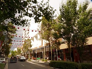
Gordon is a suburb on the Upper North Shore of Sydney in the state of New South Wales, Australia 14 kilometres (9 mi) north-west of the Sydney Central Business District and is the administrative centre for the local government area of Ku-ring-gai Council. East Gordon is a locality within Gordon and West Gordon within West Pymble.

Singleton is a town on the banks of the Hunter River in New South Wales, Australia. Singleton is 144 km (89 mi) north-north-west of Sydney, and 70 km (43 mi) northwest of Newcastle. At June 2018, Singleton had an urban population of 16,346.

Muswellbrook is a town in the Upper Hunter Region of New South Wales, Australia, about 243 km (151 mi) north of Sydney and 127 km (79 mi) north-west of Newcastle.

Tumut is a town in the Riverina region of New South Wales, Australia, situated on the banks of the Tumut River.

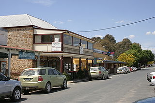
Berrima is a historic village in the Southern Highlands of New South Wales, Australia, in Wingecarribee Shire. The village, once a major town, is located on the Old Hume Highway between Canberra and Sydney. It was previously known officially as the Town of Berrima. It is close to the three major towns of the Southern Highlands; Mittagong, Bowral and Moss Vale.

Mount Victoria is a small township in the Blue Mountains of New South Wales, Australia. It is the westernmost village in the City of Blue Mountains, located about 120 kilometres (75 mi) by road from the Sydney central business district and at an altitude of about 1,052 metres (3,451 ft) AHD . The settlement had a population of 823 people at the 2011 Census.
Rouse Hill is a suburb of Sydney, in the state of New South Wales, Australia. Rouse Hill is located in the Hills District, 43 kilometres north-west of the Sydney central business district and 19 kilometres north-west of the Parramatta central business district. It is in the local government areas of The Hills Shire and City of Blacktown. Rouse Hill Town Centre is at the heart of the suburb, which contains a busy Town Square.

Moss Vale is a town in the Southern Highlands of New South Wales, Australia, in the Wingecarribee Shire. At the 2016 census, it has a population of 8,579 and is sited on the Illawarra Highway, which connects to Wollongong and the Illawarra coast via Macquarie Pass.

Coleambally is a small town in the Riverina of New South Wales, Australia, in Murrumbidgee Council.
Bungendore is a town in the Queanbeyan Region of New South Wales, Australia, in Queanbeyan-Palerang Regional Council. It is on the Kings Highway near Lake George, the Molonglo River Valley and the Australian Capital Territory border. It has become a major tourist centre in recent years, popular with visitors from Canberra and some of it has heritage protection. It has expanded rapidly in recent years as a dormitory town of Canberra.

Gundaroo is a small village in the Southern Tablelands of New South Wales, Australia and in Yass Valley Council. It is situated to the east of the Yass River, about 16 kilometres (10 mi) north of Sutton, about 15 kilometres (9 mi) west of the Lake George range. At the 2016 census, Gundaroo "state suburb" had a population of 1,146. At the 2006 census, its "urban centre/locality" had a population of 331.

Ben Lomond is a village on the Northern Tablelands in the New England region of New South Wales, Australia. The village is situated 6 km off the New England Highway between Armidale and Glen Innes. It was located in the Guyra Shire local government area until that council was amalgamated into the Armidale Regional Council on 12 May 2016, with parts of the surrounding district in Glen Innes Severn Shire and Inverell Shire. It is primarily a farming area, with most of the residents involved in sheep, cattle and grain farming.
Yarramalong(cedar country) is a township and suburb of the Central Coast region of New South Wales, Australia, located 20 kilometres (12 mi) upstream from Wyong along the Wyong River. It is part of the Central Coast Council local government area.
East Maitland is a suburb in the City of Maitland, New South Wales, Australia. It is on the New England Highway and it has two railway stations, Victoria Street and East Maitland. Both stations are served by NSW TrainLink's Hunter Line. Hunter Valley Buses provides bus service.

Wakool is a town in the western Riverina region of New South Wales, Australia. Wakool is in the Murray River Council local government area, 791 kilometres (492 mi) south west of the state capital, Sydney and 336 kilometres (209 mi) north-west of Melbourne. At the 2016 census, Wakool had a population of 297.

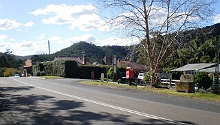
Fitzroy Falls is a village in the Wingecarribee Shire, located within the Southern Highlands region of New South Wales, Australia. The locality was known as Yarrunga, but was renamed after the 81-metre (266 ft) waterfall. At the 2016 census, Fitzroy Falls had a population of 216.
Georges Plains is a locality in the Bathurst Region of New South Wales, Australia. It had a population of 248 people as of the 2016 census.
Millfield is a town in the City of Cessnock municipality of New South Wales. It had a population of 1,006 as of the 2016 census.
Windeyer is a locality in the Mid-Western Regional Council of New South Wales, Australia. It had a population of 176 as of the 2016 census.
Warkworth is a locality in the Singleton Council region of New South Wales, Australia. It had a population of 49 as of the 2016 census.
