Related Research Articles

Newcastle, also commonly referred to as Greater Newcastle is a large metropolitan area and the second-most-populous such area of New South Wales, Australia. It includes the cities of Newcastle and Lake Macquarie and it is the hub of the Lower Hunter region, which includes most parts of the cities of Newcastle, Lake Macquarie, Maitland, Cessnock, and Port Stephens Council. Newcastle is also known by its colloquial nickname, Newy.
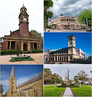
Maitland is a city in the Hunter Valley of New South Wales, Australia and the seat of Maitland City Council, situated on the Hunter River approximately 166 kilometres (103 mi) by road north of Sydney and 35 km (22 mi) north-west of Newcastle. It is on the New England Highway approximately 17 km (11 mi) from its origin at Hexham.

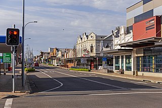
Singleton is a town on the banks of the Hunter River in New South Wales, Australia. Singleton is 202km (126 mi) north-north-west of Sydney, and 70 km (43 mi) north-west of Newcastle. At June 2018, Singleton had an urban population of 16,346.

Branxton is a town in the Hunter Region of New South Wales, Australia. Branxton is 171 kilometres (106 mi) north of Sydney via the Pacific Motorway and New England Highway. Branxton is located mostly in the City of Cessnock, but part of it is in Singleton Shire.
Cessnock is a city in the Hunter Valley of New South Wales, Australia, about 52 km (32 mi) by road west of Newcastle. It is the administrative centre of the City of Cessnock LGA and was named after an 1826 grant of land called Cessnock Estate, which was owned by John Campbell. The local area was once known as "The Coalfields", and it is the gateway city to the vineyards of the Hunter Valley, which includes Pokolbin, Mount View, Lovedale, Broke, Rothbury, and Branxton.

The Main North Line is a major railway in New South Wales, Australia. It runs through Strathfield to Armidale. The line is the main line between Sydney and Armidale. As of 1988, the line closed progressively north of Armidale with services gradually withdrawn till 2004, with the main route between Sydney and Brisbane now the North Coast line. The end of these services marked a significant shift in rail transport in the region, leading to an increased reliance on road transport and altering the dynamics of movement and passenger accessibility between these major cities..

The South Coast Railway is a passenger and freight railway line from Sydney to Wollongong and Bomaderry in New South Wales, Australia. Beginning at the Illawarra Junction, the line services the Illawarra and South Coast regions of New South Wales.

Singleton railway station is a heritage-listed railway station located on the Main Northern line in New South Wales, Australia. It serves the town of Singleton. It was added to the New South Wales State Heritage Register on 2 April 1999.

Lochinvar railway station is located on the Main Northern line in New South Wales, Australia. It serves the nearby town of Lochinvar opening on 2 July 1860.

Maitland railway station is located on the Main Northern line in New South Wales, Australia. It serves the city of Maitland opening on in 1880 as West Maitland being renamed Maitland on 1 April 1949. It is the junction station for the Main Northern and North Coast lines. It was added to the New South Wales State Heritage Register on 2 April 1999.

Beresfield railway station is located on the Main Northern line in New South Wales, Australia. It opened on 31 July 1925, serving the western Newcastle suburb of Beresfield.

Victoria Street railway station is a heritage-listed railway station located on the Main Northern line in New South Wales, Australia. It serves the Victoria Street area of East Maitland. It was added to the New South Wales State Heritage Register on 2 April 1999.

Muswellbrook railway station is a heritage-listed railway station located on the Main Northern line in Muswellbrook, New South Wales, Australia. The station serves the town of Muswellbrook and was designed by John Whitton, the Chief Engineer of NSW Railways. It is also known as Muswellbrook Railway Station and yard group and Musclebrook Railway Station. The property was added to the New South Wales State Heritage Register on 2 April 1999.

Greta is a small town in the Hunter Region of New South Wales, Australia.

Abernethy is a small town in the City of Cessnock, in the Hunter Region in the state of New South Wales, Australia. Abernethy is located 8 kilometres south-east of the town of Cessnock, NSW and is adjacent to Werakata National Park and the Aberdare State Forest. The town was founded near a coal mine and some of the historic buildings remain. In 2016 348 lived there with the median age being 32 and 74.8% being born in Australia.

The Ardglen Tunnel, also called the Liverpool Range tunnel, is a heritage-listed summit rail tunnel located on the Main North railway between the village of Ardglen and Murrurundi in New South Wales, Australia. The tunnel crosses under the Liverpool Range near its east end, below Nowlands Gap, the crossing used by the New England Highway, and provides a vital link between Newcastle and Werris Creek. The tunnel was completed in 1877 and is owned by the Transport Asset Holding Entity, a state-owned corporation of the Government of New South Wales. It was added to the New South Wales State Heritage Register on 2 April 1999.

The East Maitland–Morpeth railway is a closed branch railway in New South Wales, Australia.
Rutherford is a suburb in the City of Maitland in the Hunter Region of New South Wales, Australia. At the 2016 census, Rutherford was home to almost 12,000 residents, making it one of the most populated suburbs. The suburb consists of mixed residential development, bulky goods retail, light industry and manufacturing plants. It also has its own small commercial centre. Rutherford is served by a number of schools within the suburb. These are Rutherford Public School, St. Paul's Primary School and Rutherford Technology High School. There are also a range of indoor and outdoor sporting facilities.

Wallerawang is a small township in the Central Tablelands of New South Wales, Australia. It is located approximately 14 kilometres (8.7 mi) northwest of Lithgow adjacent to the Great Western Highway. It is also located on the Main Western railway line at the junction of the Gwabegar line. The name is also applied to the surrounding area for postal and statistical purposes.

Gillieston Heights is a suburb of the City of Maitland local government area in the Hunter Region of New South Wales, Australia, approximately 5.1 km (3.2 mi) from the Maitland CBD. Prior to 1967, the village was named East Greta however this was changed to honour former Maitland mayor and member of the New South Wales Legislative Assembly John Gillies following a poll of residents. At the 2021 census, Gillieston Heights had a population of 4,796.
References
- ↑ Whittingham station, NSWrail.net, accessed 11 August 2009.
- ↑ "ORIGINAL CORRESPONDENCE". The Maitland Mercury and Hunter River General Advertiser . Vol. XLV, no. 6211. New South Wales, Australia. 18 February 1888. p. 6 (Second Sheet to the Maitland Mercury). Retrieved 12 December 2018– via National Library of Australia.
- ↑ "Percy Valentine Storkey: The Sydney Law Student Who Won a Victoria Cross" (PDF). Sydney Law School. Retrieved 12 December 2018.
- ↑ "SINGLETON RACING CLUB". The Maitland Daily Mercury . No. 15, 793. New South Wales, Australia. 9 November 1921. p. 7. Retrieved 12 December 2018– via National Library of Australia.
- ↑ "SINGLETON RACECOURSE". The Sydney Morning Herald . No. 29, 474. New South Wales, Australia. 22 June 1932. p. 14. Retrieved 12 December 2018– via National Library of Australia.
- ↑ "SECOND TRAM MISHAP IN FIVE DAYS". Singleton Argus . New South Wales, Australia. 18 April 1945. p. 2. Retrieved 12 December 2018– via National Library of Australia.
| | This article about a railway station in New South Wales is a stub. You can help Wikipedia by expanding it. |