
The Sydney Harbour Bridge is a steel through arch bridge in Sydney, spanning Sydney Harbour from the central business district (CBD) to the North Shore. The view of the bridge, the harbour, and the nearby Sydney Opera House is widely regarded as an iconic image of Sydney, and of Australia itself. Nicknamed "The Coathanger" because of its arch-based design, the bridge carries rail, vehicular, bicycle and pedestrian traffic.
Gladesville Bridge is a heritage-listed concrete arch road bridge that carries Victoria Road over the Parramatta River, linking the Sydney suburbs of Huntleys Point and Drummoyne, in the local government areas of Canada Bay and Hunter's Hill, in New South Wales, Australia. Despite its name, the bridge is not in Gladesville.

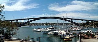
The Anzac Bridge is an eight-lane cable-stayed bridge that carries the Western Distributor (A4) across Johnstons Bay between Pyrmont and Glebe Island, on the western fringe of the Sydney central business district, New South Wales, Australia. The bridge forms part of the road network leading from the central business district, the Sydney Harbour Bridge, and Cross City Tunnel to the Inner West and Northern Suburbs.

Pacific Highway is a 790-kilometre-long (491 mi) national highway and major transport route along the central east coast of Australia, with the majority of it being part of Australia's Highway 1. The highway and its adjoining Pacific Motorway between Brisbane and Brunswick Heads and Pacific Motorway between Sydney and Newcastle links the state capitals of Sydney in New South Wales with Brisbane in Queensland, approximately paralleling the Tasman Sea and the Coral Sea of the South Pacific Ocean coast, via regional cities and towns like Gosford, Newcastle, Taree, Port Macquarie, Kempsey, Coffs Harbour, Grafton, Ballina, Byron Bay, Tweed Heads and the Gold Coast, which is part of Queensland. Additionally, between Brunswick Heads and Port Macquarie, the road is also signed as Pacific Motorway, but has not been legally gazetted as such.
Stockton is a suburb of Newcastle, New South Wales, Australia, located 600 m (0.4 mi) from Newcastle's central business district. It is the only residential suburb of the City of Newcastle that lies north of the Hunter River.

The Ryde Bridge, also called the Uhrs Point Bridge, are two road bridges that carry Concord Road, part of the A3, across Parramatta River from Ryde in the northern suburbs of Sydney to Rhodes in Sydney's inner west, in New South Wales, Australia.

The Fig Tree Bridge is a road bridge that carries Burns Bay Road across the Lane Cove River, and connects the suburbs of Hunters Hill in the south and Linley Point in the north, located approximately seven kilometres northwest of the central business district of Sydney in New South Wales, Australia. The concrete girder bridge carries motor vehicles, and a grade-separated footpath and cycleway.

The Captain Cook Bridge is a road bridge that carries Taren Point and Rocky Point Roads across the Georges River in southern Sydney, in the state of New South Wales, Australia. The precast prestressed concrete girder bridge crosses near the river mouth as it empties into Botany Bay; and links the St George and Sutherland areas of Sydney. The bridge comprises a dual carriageway with three lanes in each direction of highway grade-separated conditions; and pedestrian and bicycle traffic, via two grade-separated paths. on the eastern and western sides of the bridge.
Sydney Bypass refers to a number of roads, existing and proposed, that motorists can use to avoid the congested approaches to the Sydney central business district (CBD). The main bypasses are:

Kooragang is the northernmost and largest suburb of the city of Newcastle, in the Hunter Region of New South Wales, Australia. Dominated by Kooragang Island, the eastern part of the suburb is primarily industrial, while the western part of the suburb consists of nature reserves. Covering an area of 35.4 km2 (13.7 sq mi), at the 2016 census, there were no people living in the suburb.

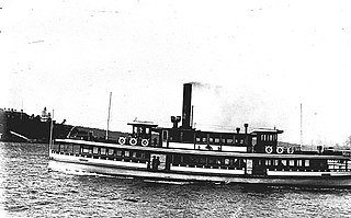
Kalang, later Sydney Queen, was a vehicular ferry and later show boat on Sydney Harbour. A steel-hulled, steam screw ferry, she and sister Kara Kara were the largest vehicular ferries to operate in Sydney and the largest ferries operated by Sydney Ferries Limited.

The Peats Ferry Bridge is a steel truss bridge that carries the Pacific Highway (B83) across the Hawkesbury River, between Kangaroo Point and Mooney Mooney Point, located 40 kilometres (25 mi) north of Sydney in New South Wales, Australia. The bridge carries the Hornsby to Kariong section of highway, while the adjacent Brooklyn Bridge carries the Pacific Motorway (M1).
Sydney Ferries Limited operated ferry services on Sydney Harbour from 1900 until June 1951.
Lady Denman is a former Sydney Harbour ferry built in 1912 for the Balmain New Ferry Company. She was later run by Sydney Ferries Limited and its government successors. She is now preserved at the Jervis Bay Maritime Museum near her original build site in Huskisson, New South Wales, Australia.

SS Kooroongaba was a vehicle ferry built for Sydney Ferries Limited. It later operated in Newcastle.

The Stockton ferry service is a ferry service in Newcastle, New South Wales. Operated by Newcastle Transport under contract to Transport for NSW, it crosses the Hunter River from the Newcastle CBD at Queens Wharf to Stockton.
The coastal coal-carrying trade of New South Wales involved the shipping of coal—mainly for local consumption but also for export or coal bunkering—by sea to Sydney from the northern and southern coal fields of New South Wales. It took place in the 19th and 20th centuries. It should not be confused with the export coal trade, which still exists today. There was also an interstate trade, carrying coal and coke to other Australian states that did not have local sources of black coal.

Sydney Harbour ferry services date back to the first years of Sydney's European settlement. Slow and sporadic boats ran along the Parramatta River from Sydney to Parramatta and served the agricultural settlements in between. By the mid-1830s, speculative ventures established regular services. From the late-nineteenth century the North Shore developed rapidly. A rail connection to Milsons Point took alighting ferry passengers up the North Shore line to Hornsby, New South Wales via North Sydney. Without a bridge connection, increasingly large fleets of steamers serviced the cross harbour routes and in the early twentieth century, Sydney Ferries Limited was the largest ferry operator in the world.

The Hexham Bridge is a pair of road bridges that carry the Pacific Highway across the Hunter River from Tarro to Tomago in the Hunter Region of New South Wales, Australia. It comprises two separate structures; a steel truss bridge opened on the 17 December 1952 by Acting Minister of Transport George Weir and a concrete bridge opened in 1987.
The Tourle Street Bridge is a pair of road bridges that carry Tourle Street across the Hunter River from Mayfield West to Kooragang in the Hunter Region of New South Wales, Australia.

