
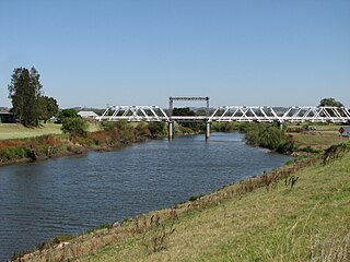
The Hunter River is a major river in New South Wales, Australia. The Hunter River rises in the Liverpool Range and flows generally south and then east, reaching the Tasman Sea at Newcastle, the second largest city in New South Wales and a major harbour port. Its lower reaches form an open and trained mature wave dominated barrier estuary.

Windsor is a historic town in north-west of Sydney, New South Wales, Australia. It is the council seat of the Hawkesbury local government area. The town sits on the Hawkesbury River, enveloped by farmland and Australian bush. Many of the oldest surviving European buildings in Australia are located at Windsor. It is 46 km (29 mi) north-west of the Sydney CBD, on the fringes of urban sprawl.

Dungog is a country town on the Williams River in the Hunter region and a small part of the Mid North Coast region of New South Wales, Australia. Located in the middle of dairy and timber country, it is the centre of the Dungog Shire local government area and at the 2016 census it had a population of 2,025 people. The area includes the Fosterton Loop, 22 kilometres (14 mi) of road, used in the annual Pedalfest. A small portion of Dungog lies in the Mid-Coast Council LGA.

Paterson River, a perennial river that is part of the Hunter River catchment, is located in the Hunter and Mid North Coast regions of New South Wales, Australia.

Victoria Street railway station is a heritage-listed railway station located on the Main Northern line in New South Wales, Australia. It serves the Victoria Street area of East Maitland. It was added to the New South Wales State Heritage Register on 2 April 1999.
Avon River, a perennial stream of the Manning River catchment, is located in the Upper Hunter region of New South Wales, Australia.

Woodville is a rural suburb in the Hunter Region of New South Wales, Australia that is shared between the Port Stephens and Maitland local government areas (LGA). Most of the suburb lies to the east of the Paterson River in the Port Stephens LGA while a small area of approximately 1.3 square kilometres (0.5 sq mi), to the west of the Paterson, is within the boundaries of the Maitland LGA.

Clarence Town is both a primarily rural locality and a township in the Dungog Shire local government area in the Hunter Region of New South Wales, Australia. It is 193 kilometres (120 mi) north of Sydney, 54 km (34 mi) north-north-west of Newcastle, and 28 km (17 mi) from the Pacific Highway at Raymond Terrace. The locality is bisected by the Williams River. The township sits just to the west of the river about 32 km (20 mi) upstream from where it flows into the Hunter River at Raymond Terrace.
Monkerai is a large rural area in the hills in the land between Dungog and Gloucester in Mid-Coast Council, in the Hunter Region, New South Wales, Australia.

Vacy is a locality of the Dungog Shire local government area in the Hunter Region of New South Wales, Australia. Situated between Gresford and Paterson, it includes the village of Vacy, which was founded in the 1820s as a private town by John Cory, the owner of a large land grant. Vacy began to prosper in the 1850s and was a busy town by the 1870s. It remained a private town until it was sold in 1927 by the Cory family. The village is located at the junction of the Paterson and Allyn rivers. At the 2011 census, Vacy had a population of 547.
The Chichester River, a perennial stream of the Hunter River catchment, is located in the Hunter region of New South Wales, Australia.

Gloucester River, a perennial river and major tributary of the Manning River catchment, is located in the Mid North Coast hinterland New South Wales, Australia.

Allyn River, a perennial stream of the Hunter River catchment, is located in the Hunter region of New South Wales, Australia.
Yowaka River, a perennial river of the Pambula River catchment, is located in the South Coast region of New South Wales, Australia.

Morpeth Bridge is a heritage-listed road bridge over the Hunter River at Morpeth, New South Wales, Australia. It was designed by Percy Allan and built from 1896 to 1898 by Samuel McGill. It is also known as Morpeth Bridge over the Hunter River. The property is owned by Transport for NSW.

Clarence Town Courthouse is a heritage-listed former courthouse and now museum at 49 Grey Street, Clarence Town, Dungog Shire, New South Wales, Australia. It was built from 1868 to 1869. It was added to the New South Wales State Heritage Register on 2 April 1999.

The Williams River bridge, Clarence Town is a heritage-listed road bridge that carries Limeburners Creek Road across the Williams River located in Clarence Town, New South Wales, Australia. It was designed by the New South Wales Public Works Department and built by J. K. McKenzie. The property is owned by Transport for NSW. It was added to the New South Wales State Heritage Register on 20 June 2000.

The Cooreei Bridge over Williams River is a heritage-listed road bridge that carries Main Road across Williams River in Dungog, New South Wales, Australia. The property is owned by Transport for NSW. It was added to the New South Wales State Heritage Register on 20 June 2000.

The Karuah River bridge is a heritage-listed road bridge that carries the Weismantels-Dingadee Road across the Karuah River, located at Monkerai, New South Wales, Australia. The bridge is also known as the Monkerai Bridge over Karuah River. The bridge is owned by Transport for NSW. It was added to the New South Wales State Heritage Register on 20 June 2000.
The Dunmore Bridge is a heritage-listed road bridge that carries Clarence Town Road across the Paterson River in Woodville, New South Wales, Australia. It was designed by Percy Allan and built in 1899 by Morpeth contractor, S. McGill. The property is owned by Transport for NSW. It was added to the New South Wales State Heritage Register on 20 June 2000.

